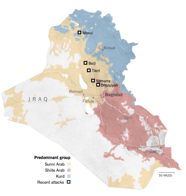
Well, Iraq is in the news again. Basically because the Islamist insurgency in Syria has now crossed the border—to be fair, though, that happened awhile back—and taken control over swathes of northern Iraq. Part of that swath includes the city of Mosul, Iraq’s second-largest city with a population of almost 2 million.
The New York Times has been putting together a series of maps to explain the background of why this is happening (hint: that Shia–Sunni divide we talked about years ago, well it’s back) as well as where this is happening.
The Shia–Sunni–Kurdish divide
Credit for the piece goes to Sarah Almukhtar, Jeremy Ashkenas, Bill Marsh, Archie Tse, Tim Wallace, Derek Watkins, and Karen Yourish.
Author: Brendan Barry
I am a graphic designer who focuses on information design. My day job? Well, they asked me not to say. But to be clear, this blog is my something I do on my own time and does not represent the views of…my employers. I think what I can say is that given my interest in information design—be it in the shape of clear charts, maps, diagrams, or wayfinding systems—I am fortunate that my day job focuses on data visualisation. Outside of work, I try to stay busy with personal design work. Away from the world of design, I have become an amateur genealogist and family historian. You will sometimes see that area of work bleed into my posts.
View all posts by Brendan Barry