As of today, Queen Elizabeth is the longest reigning British monarch. She has surpassed the record of the famous Queen Victoria, Elizabeth’s great-great-grandmother at 63 years and seven months. Obviously a lot of things have changed over those 63 years, and in this article the BBC uses a graphic to look at how the world stage has changed.
Queen Elizabeth II’s reign
Credit for the piece goes to the BBC graphics department.
I was on holiday for a little bit, so apologies for the lack of content. But, now I am back for a little while. So here’s hoping life gets a bit more settled and content can be published more regularly.
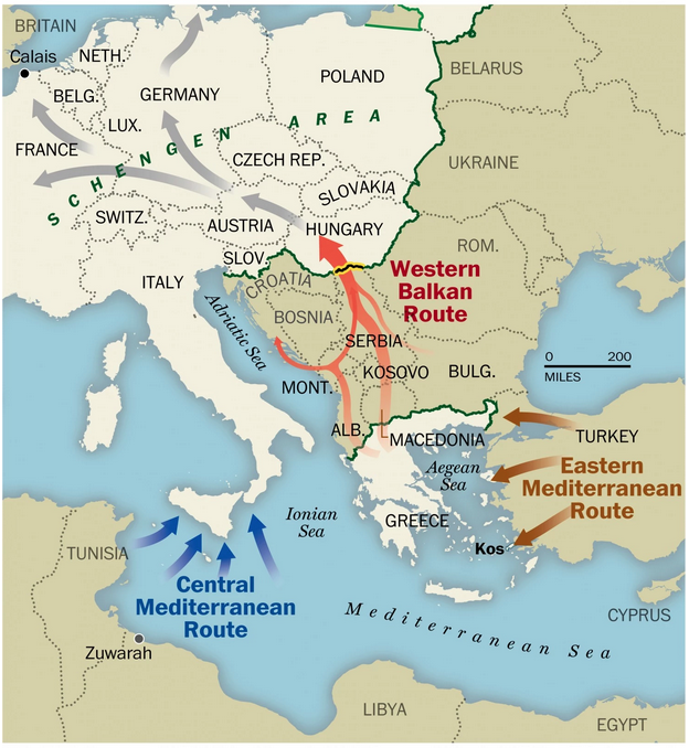
Whilst I was on holiday, I only checked the news a few times and most of it seemed to be consumed by the migration/refugee crisis facing the European Union. While I could type away ad nauseam on the issue, the best way to engage you on the topic would be through a Washington Post map that details the different paths migrants/refugees use.
Migration map routes
I am hoping that in the future I will find sufficient other charts and graphics others have made to comment on a very important issue.
Credit for the piece goes to the Washington Post graphics department.
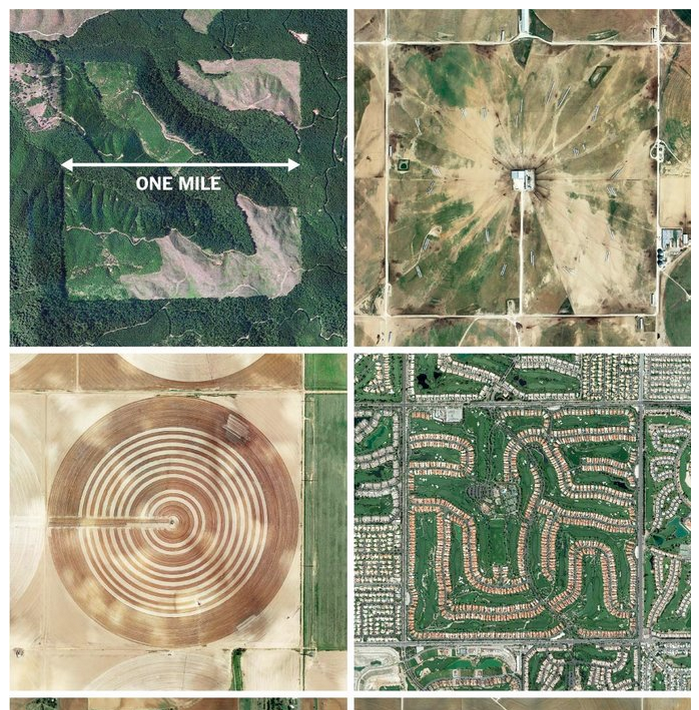
Today’s post relates very much to yesterday’s post. But this one is from the New York Times and uses aerial photography to showcase how the Jefferson grid system works in reality after it was implemented as shown yesterday.
The Jefferson grid
Credit for the piece goes to the person behind the Instagram account @the.jefferson.grid
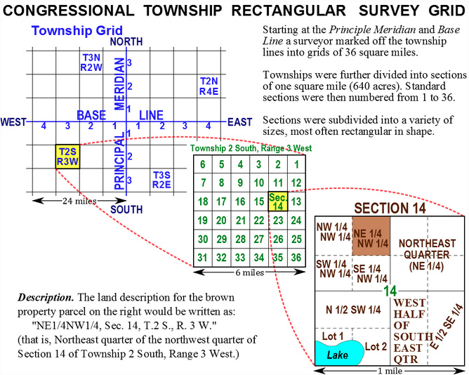
A few weeks back I looked at my ancestral family’s land grant in Wisconsin. Unlike land on the East Coast that was surveyed and organised by pioneers in different colonies using different sets of rules, after the formation of the United States, surveyed land was organised into townships that had subdivisions. In this blog post I found about the subject, there are several diagrams and maps that explain just how this system worked.
How western lands were organised
If you’re curious about how western land was organised, its worth a quick read.
Credit for the piece goes to Living History Farms.
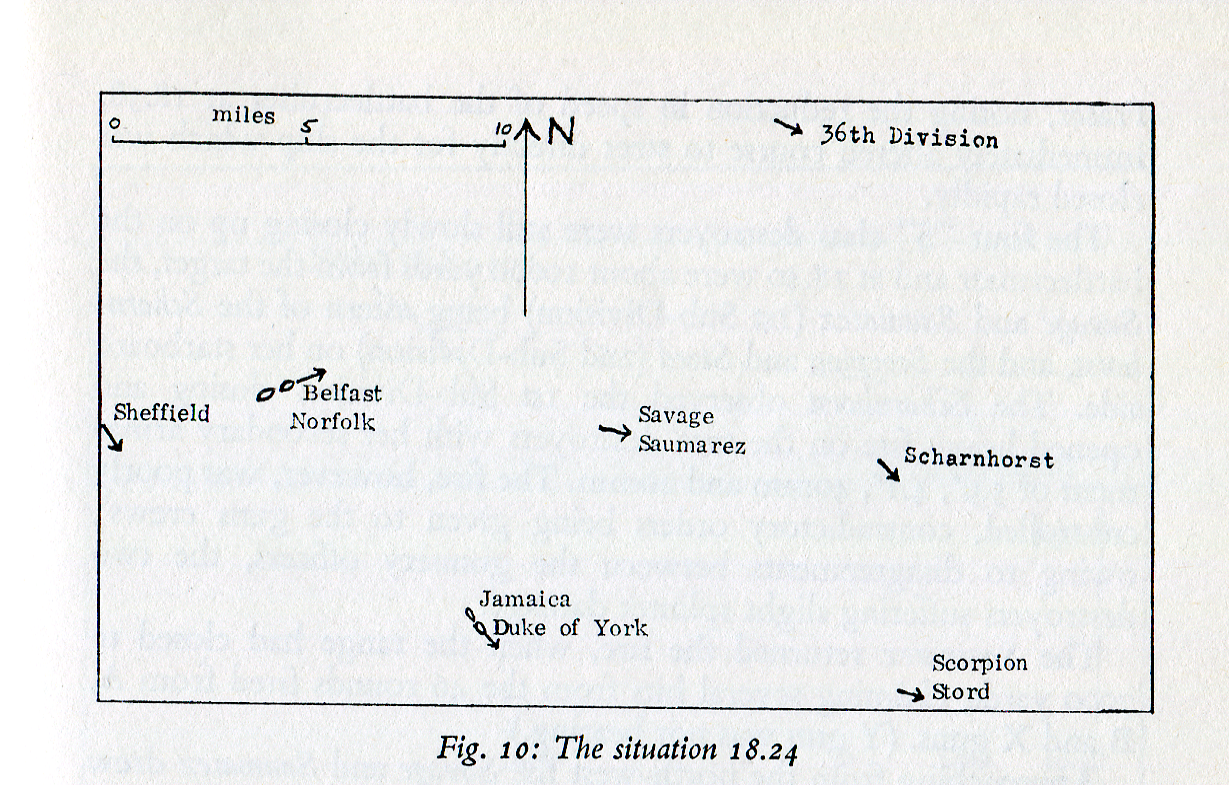
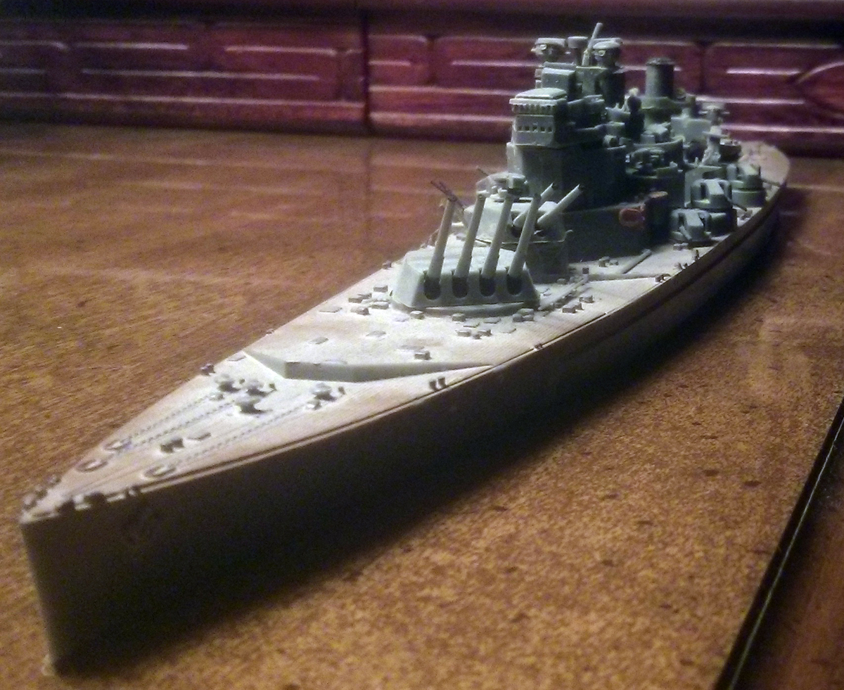
Last week my uncle died suddenly and today I will be at his funeral back home. So if you will indulge me a personal piece today, we have a graphic from A.J. Watts’ 1970 book Loss of the Scharnhorst. The Scharnhorst was a German World War II battlecruiser sunk in the Battle of the North Cape. But, I will return to that in a moment.
Battle of the North Cape
I was fortunate—if one can truly say that under the circumstances—the last week to be incredibly busy in both my personal and professional lives so that I did not have time to process the news of my uncle’s death. But now I am on a two-hour flight to Philadelphia where I have nothing but time.
When I was much younger than I am today, my uncle occasionally surprised me with models of famous warships. I distinctly recall one being the World War II German battleship Bismarck. Eventually I began building my own models and following that I become interested in naval history.
Today very few of the models remain. I eventually took after my uncle in another model-related hobby—their destruction. Inspired by his stories of recreating Pearl Harbour, I took my models—his gifts and mine—into the woods near my house and in creeks and ponds there I recreated historical or entirely fantastical battles. Very few of the models survived my childhood.
Then in 2002 my great-grandmother passed away in Ganister, Pennsylvania and the whole of the family headed up to settle her estate. While the adults kept us out of the house, my uncle took me and my cousins to the garage where we found the most fantastic treasure—giant wooden models my uncle had built in his youth.
My uncle set the first wooden model into Piney Creek. These models were as accurate as they could be, two to three feet long and made from scraps of wood. My cousins and I took our places near a rickety bridge and armed ourselves with giant rocks. My uncle then let the Tirpitz sail and we hurled rocks until the model broke and shattered and passed out of range. Then came the Prinz Eugen. Then other various German ships.
But I clearly recall he put the Scharnhorst, the old German World War II battlecruiser, into the creek that day. And my uncle would tell us stories of the ships. And while our hurling rocks in an Appalachian creek is far from a historical reenactment, my cousins and I clearly did our damage as it sailed out of sight down into the Juniata.
And that brings me to the scan above. Because in reality, the Scharnhorst met her end in the Battle of the North Cape off northern Norway on 26 December 1943. She was engaged by the British battleship HMS Duke of York, a King George V class battleship, among many other Royal Navy ships. And in my room to this day is the only surviving model from my uncle: HMS Prince of Wales, sister ship to the HMS Duke of York.
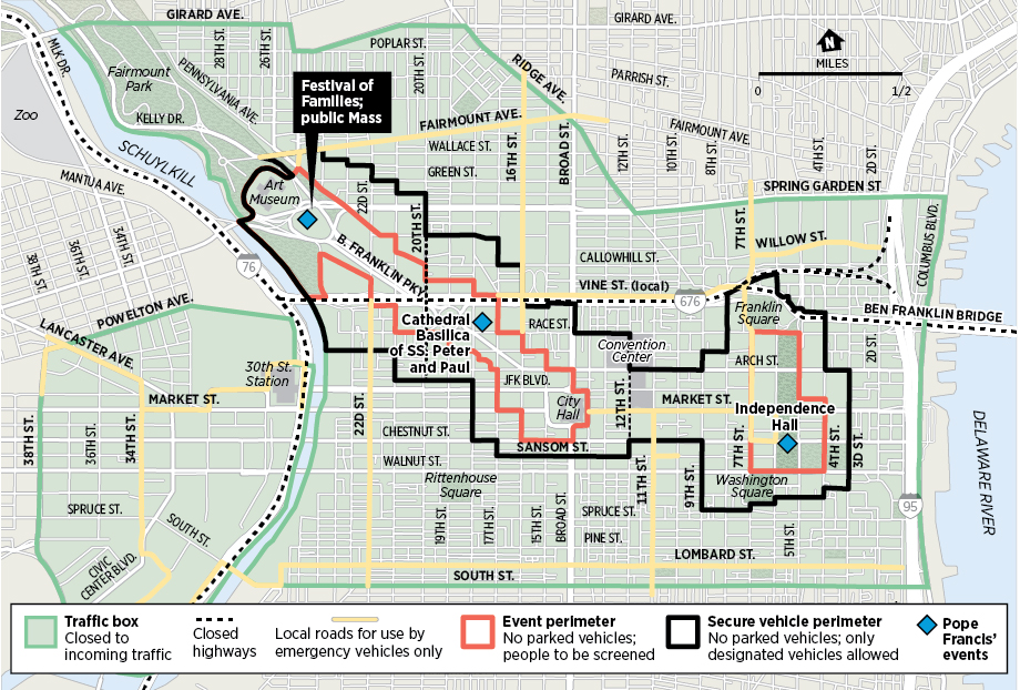
For those not from Philadelphia, you might not know the Pope is visiting the city in September for a global conference of sorts. While that is great news for the followers and believers, it means absolute hell for the other residents of the city. So finally the security map has been published, detailing just where vehicles can go and where inspections will be held.
Real security map
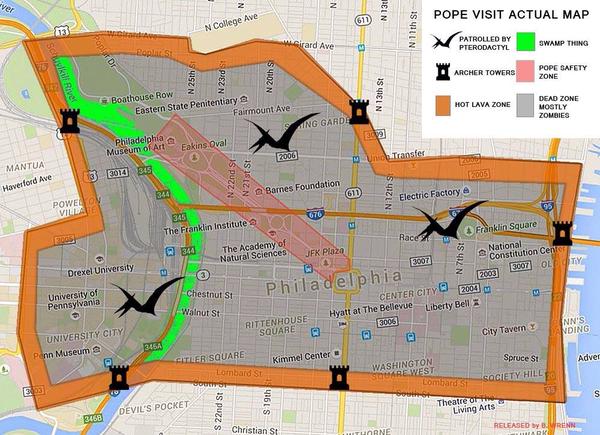
But the best—or worst—part was that for several weeks there was no public knowledge of just what would happen. And that meant maps like the one below were produced. Personally, I think this one would be a lot more fun.
This map would be far more interesting
Credit for the real one goes to the graphics department of philly.com.
Credit for the more awesomer one goes to B. Wrenn.
As the 10th anniversary of Hurricane Katrina approaches, NPR looked at how the population of the New Orleans area has changed. The piece is a nice combination of clean, clear, sharp graphics and insightful text.
The population of New Orleans proper
Credit for the piece goes to Paula Martinez, David Eads, and Christopher Groskopf.
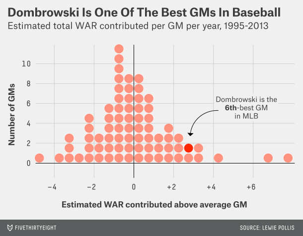
The Boston Red Sox made big baseball news last night by announcing the hiring of former Tigers GM Dave Dombrowski to head Boston’s baseball operations. The second big piece of baseball news, Boston’s GM, Ben Cherington, has resigned as he does not want to work under Dombrowski.
As you might figure, I enjoy data’s role in baseball. That Dombrowski is not the biggest analytics-embracing GM worries me a bit. But after re-reading FiveThirtyEight’s piece on the value he brings—naturally through some data and analysis—I think I will at least give him a season or two before calling for his head.
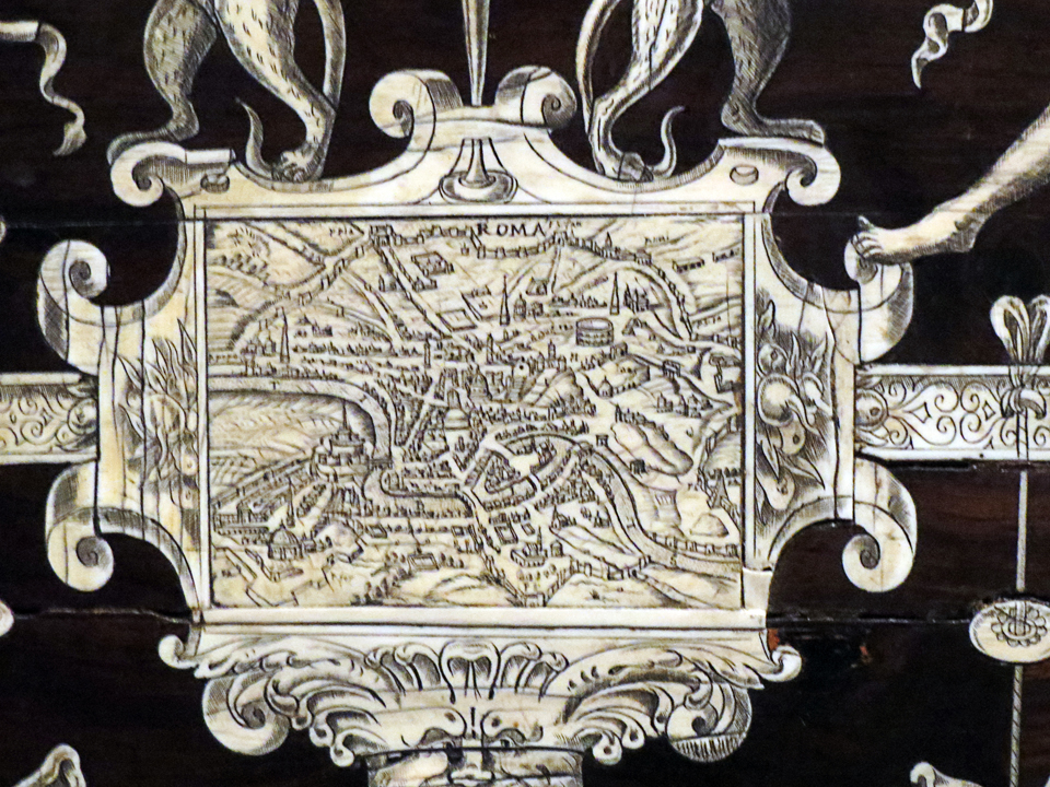
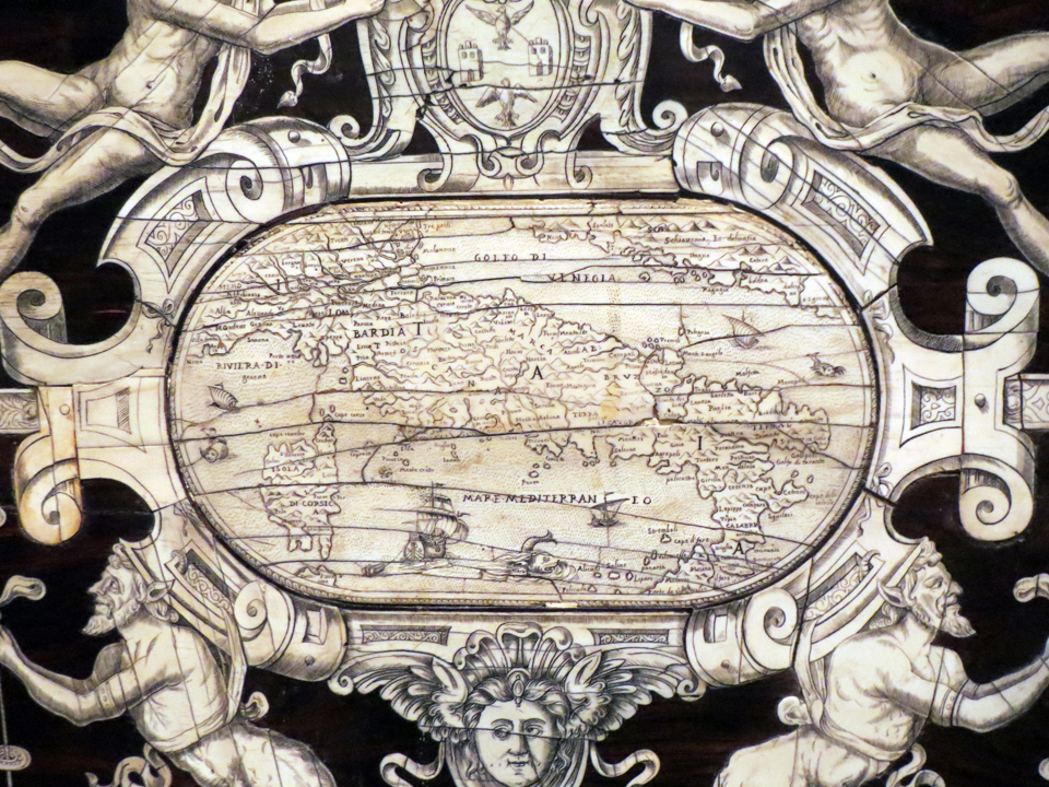
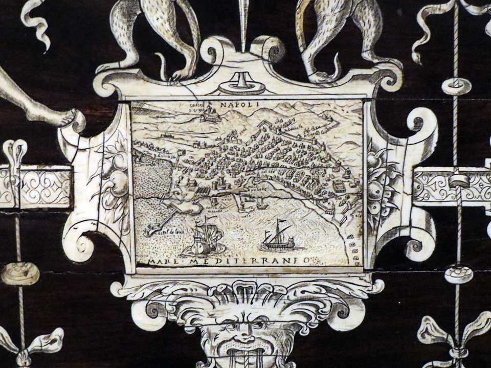
While in Philadelphia last weekend, I managed to make it to the Philadelphia Museum of Art for a little bit. And today’s piece is a nice map—ivory on ebony—from a 16th century Italian writing cabinet.
The overall chestThe detail for RomeThe centre mapThe detail for Naples
Credit for the piece goes to the workshop of Iacobus Fiamengo.
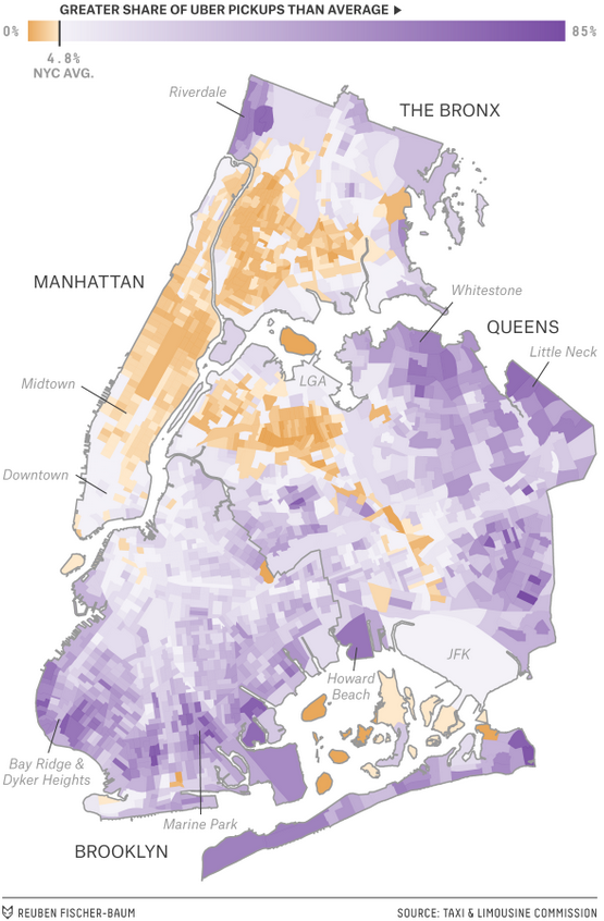
I just spent the weekend back in my hometown of Philadelphia and while we walked most places, there were a few Uber rides. As someone who doesn’t use the app and normally will hail a taxi when necessary, I had been looking forward to posting this piece. FiveThirtyEight looked at data for New York comparing Uber to taxis.