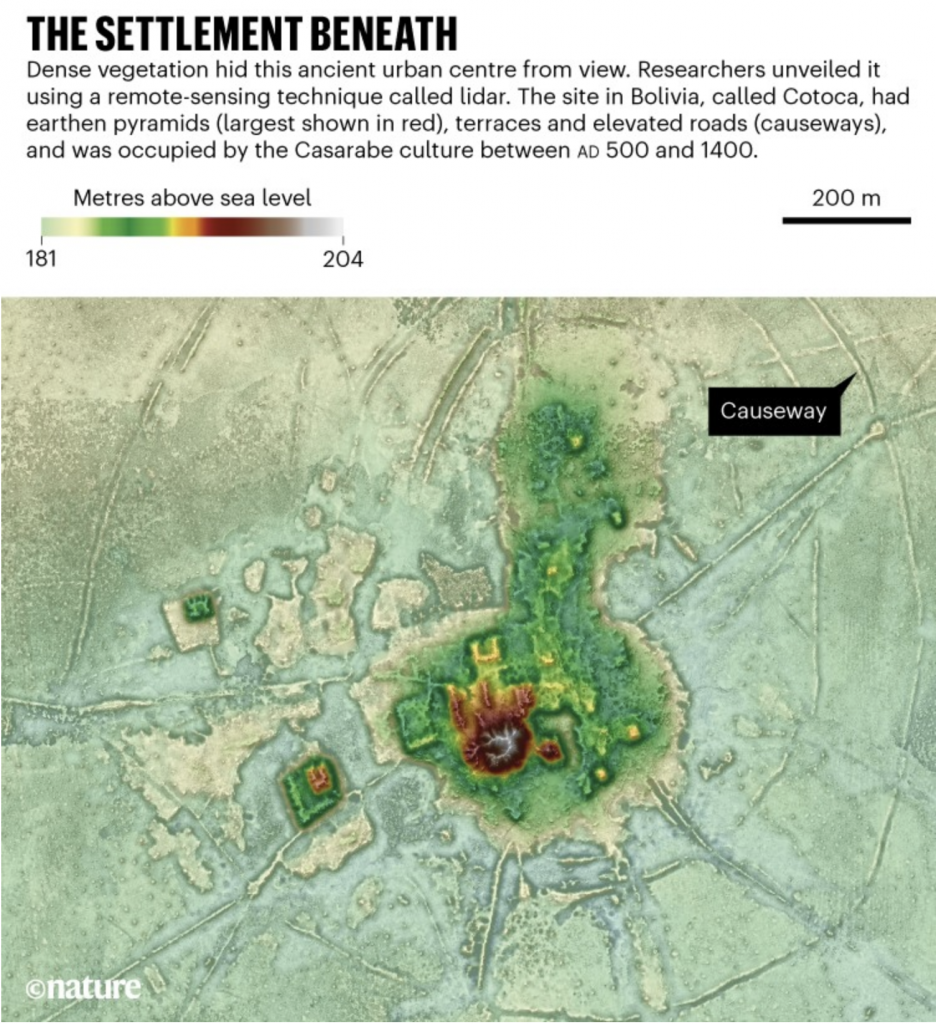
Who did not like Indiana Jones growing up as a kid? Or better yet, stories of explorers like Heinrich Schliemann, who discovered the lost city of Troy? The ancient world boasted a number of civilisations that no longer exist. But not all lost civilisations date back thousands of years. A recent article in Nature details how modern-day explorers used technology instead of trowels to discover urban centres dating only back 1500 years ago, the time at which Europe was just discovering the American continents.
The article includes a map of the elevations uncovered by LIDAR, which is like radar but with lasers. These wavelengths have the ability to penetrate the thick Amazonian jungle and reveal what sits upon the ground and the differences in height between them. This allows human-built structures to become rather apparent in contrast to the natural topography.
Can I build this in SimCity?
You can not only readily discern the pyramids and central civic/religious structures, but also the infrastructure like causeways, moats, and fortifications. They provide a fascinating insight into civilisations whose homelands are not easily accessible being that they are deep within the Amazon rain forest.
Here I like how the designers annotated at least a causeway, though I would also have enjoyed notes pointing out suppositions and hypotheses as to what the other structures may (or may not) be.
Credit for the piece goes to Heiko Prümers, Carla Jaimes Betancourt, José Iriarte, Mark Robinson, and Martin Schaich.
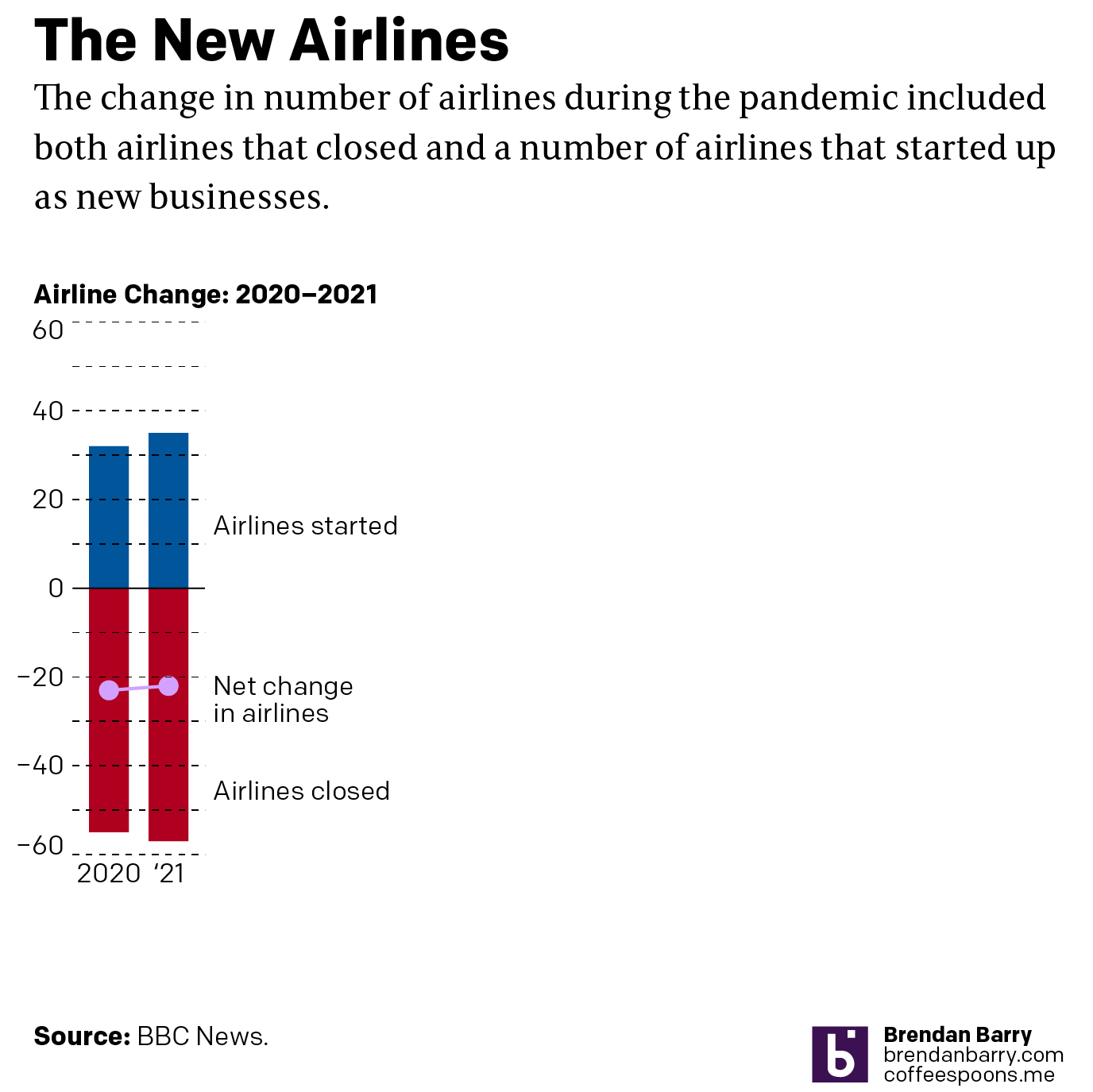
I noticed an interesting thing this morning. Over the holiday weekend I bookmarked a BBC News article about new airlines because it included a small graphic showing the number of airlines started during the pandemic (32) and the number of new airlines lost during the pandemic (55). The graphic used a stock three-dimensional illustration of a passenger airlines with a blank white body. From the top of the body rose two white bars, next to the left was the shorter of the two with a 32. The right was taller and had a 55. Above each was a header saying something to the effect of “Airlines started in 2020” and “Airlines lost in 2020”, respectively. Funny thing this morning that when I returned to the bookmark with this post in mind, the article’s graphic had disappeared.
This weekend I happened to start re-reading 1984, George Orwell’s classic dystopian novel about a man named Winston Smith. He works in the Records Department and is tasked with “rectifying” misstatements. I had just finished reading the section where Orwell describes Smith’s work wherein he takes previously published newspaper articles about statistics and figures and then edits them to include new numbers aligned with the actual outputs. This way should anyone read the old article for evidence of a previous past, they find the output forecasts have always been correct. He then destroys the written record of the old past by dumping it into a memory hole, a pneumatic tube that delivers it straight to a furnace where the old past is incinerated and thus replaced with Smith’s new version.
When I read the article again, because the graphic was gone, I read a paragraph that had figures for 2021. I cannot recall those numbers being present earlier this weekend. But they are roughly where I remember the old graphic being. Yet the article includes no note about any edits to a previous version let alone what those edits may have been. And so now I am left wondering if I really saw what I think I remember that I saw. How very Orwellian.
But let’s assume I did see what I thought I saw, the graphic was actually unnecessary. It presented two figures, 32 and 55. The bar chart itself had no axis labels and that made it a bit difficult to believe the numbers themselves. It did not help that the white bars blended almost seamlessly into the white body of the airliner. Moreover, the graphic was large and fit the full width of the text column. For two figures.
My initial goal was to show this graphic I made to show just how little space truly needs to be used to show an effective graphic. I also changed the direction of the bars. Instead of making one bar about the positive change and the other the negative change, I made both bars about the change. Therefore the one bar moved upwards with the positive (32) and the other downwards with the negative (55). I then plotted a dot to show the net change between the two. Yes, 32 airlines were created in 2020. But that still made for a net loss of 23 that year.
But because the graphic was missing and there was some new text for 2021 figures, I decided to incorporate them as well to show how the trend basically continued year over year.
Finally, a graphic
I left the white space to the right to illustrate how you really do not need a full-width graphic to display only six data points, itself a three-fold increase on the original graphic’s data content. The original graphic contained more illustrated plane than it did data content.
Graphics should be about the data, not about the splashy, flashy, whizbang background content that ultimately distracts our attention away from what should be the focal point of the piece: the data. The article still contains photos of planes with the livery of the new airlines, of empty terminals to represent the pandemic losses, and portraits of executives. This graphic did not need an illustrated plane taking over the graphic. It needed to only show those two numbers.
I would even contend that the article could have made do with a simple factette, two big numbers. Airlines closed in 2020 and the airlines opened. It need not be fancy, but it quickly delivers the big numbers with which the reader should be concerned. You don’t need to see an aircraft or a terminal. You could add some colour to the numbers or even a minus sign as there is a significant difference between a 55 and a -55. But all in all, the graphic need not be full width like it was originally.
But I think we should all keep in mind the value of transparency. The graphic did exist, of that I am certain. But future readers or even my sanity cannot be sure that it did. And in an era where “fake news” and fact-checking are important, I wonder if we need to be including corrections notes in more of our news articles. Because if we lose faith in our news, we have little left to lean upon in our societal discourse about the events of our time.
Well that was a week. But at least we made it to Friday and for my American readers and myself this weekend and its bank holiday on Monday, Memorial Day, mark the unofficial beginning of summer. So thanks to Indexed, it’s time to head down to the beach and hang ten (serfs).
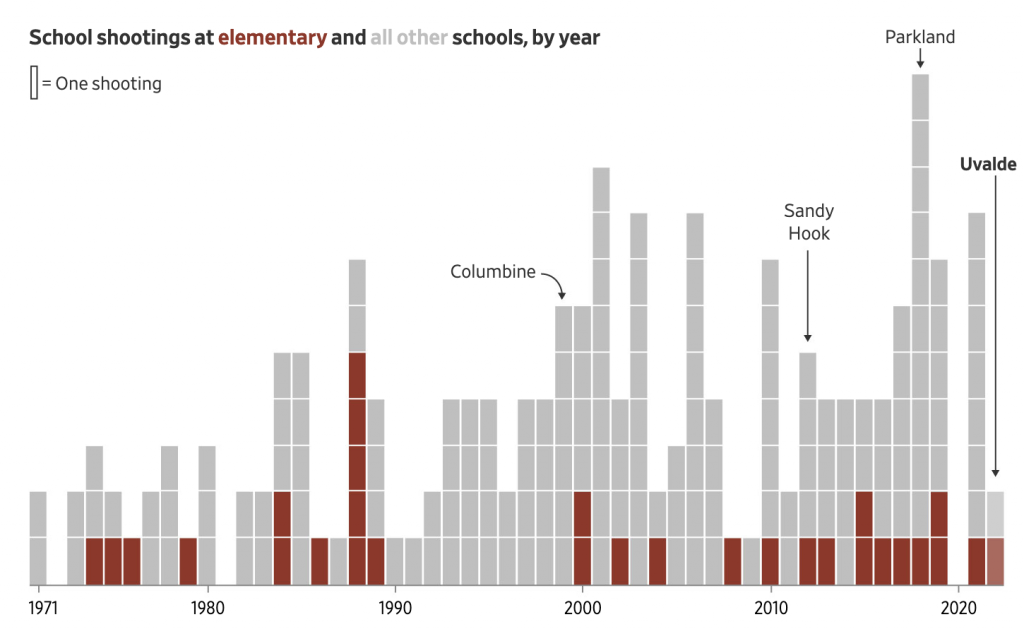
The Wall Street Journal put together a nice piece about the uptick in elementary school shootings, both in the number of shootings and the number of deaths. It used two bar charts, regular and stacked, and a heat map to tell the story. The screenshot below is from a graphic that looks at the proportion of school shootings that occur at elementary schools. They are not as common, but as other graphics in the article show, they can be quite deadly.
Not a great trend…
The graphic above does a nice job of distilling the horror of a tragedy into a single rectangle. That is an important task because it allows us to detach ourselves and more rationally analyse the situation. Unfortunately the analysis is that yes, Virginia, things really have been getting worse.
Overall the article is simple but soberingly effective. School shootings are a problem with which American society has not dealt and my cynical side believes with which we will continue to not deal.
Credit for the piece goes to James Benedict and Danny Dougherty.
Remember how just last week I posted a graphic about the number of under-18 year olds killed by under-18 year olds? Well now we have an 18-year-old shooting up an elementary school killing 19 students and two teachers. Legally the alleged shooter, Salvador Ramos, is an adult given his age. But he was also a high-school student, reportedly more of a loner type. Legally an adult, perhaps, but I’d argue still more of a child. At least a young adult.
Well, as I noted above, here we are again, kids killing kids. With guns!
And it does look like it correlates with those state with more liberal gun laws, including Texas.
If you keep doing the same thing, but expect different results…
For those who don’t know, China currently engages in ethnocide, or cultural genocide in its western province of Xinjiang, a province with a majority of its population being Uighurs, a Turkic Muslim people. Ethnocide is a term I prefer over genocide as genocide more commonly refers to practices like those in Nazi Germany or 1990s Rwanda and Bosnia wherein people are systematically executed and murdered. Ethnocide leaves a people alive but aims to destroy and extinguish their culture ultimately replacing it with that of another. In this case, Beijing’s policy is to strip the Uighurs of their Muslim culture and identity and replace it with loyalty to China and the Chinese Communist Party.
The BBC have just published what they call the Xinjiang Police Files, files and data hacked off of Chinese government servers and then handed over to a US-based expert on Xinjiang and the atrocities there. That person then handed copies to the BBC, which has verified much of the content.
There is not much by way of data visualisation or information design, but the story is worth mentioning because maybe over one million people are being forcibly detained and “re-educated” by Beijing. One of the articles about the files, however, does have a small graphic of one of the “re-education camps”, i.e. prison, and details its design and the facilities therein.
Certainly not like any school I have ever attended…
Political liberalism and pluralism are messy. Often it means we hear and listen to things with which we disagree, sometimes vehemently. Freedom of speech, expression, and religion can make us feel uncomfortable, hurt our feelings, and even sick to our stomachs. But that is also the price of our liberty to speak, express, and pray ourselves. Because we only need to look to China to see what happens when a society or a government decides what is or isn’t acceptable speech (peaceful protests against the government), expression (growing out a beard), or religion (praying in a mosque). An authoritarian regime, an anti-liberal regime, will attempt to stifle, silence, and ultimately imprison those who go against the (Chinese Communist) party line.
1984 rings a little more true each year.
Credit for the piece goes to John Sudworth and the BBC’s Visual Journalism Team.
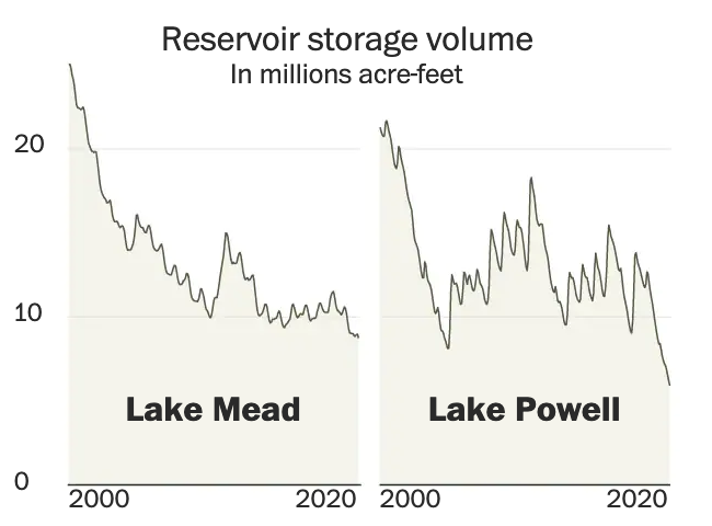
Last week the Washington Post published a nice long-form article about the troubles facing the Colorado River in the American and Mexican west. The Colorado is the river dammed by the Hoover and Glen Canyon Dams. It’s what flows through the Grand Canyon and provides water to the thirsty residents of the desert southwest.
But the river no longer reaches the ocean at the Gulf of California.
Why? Part drought, part population growth, and part economic activity. The article does a great job of exploring the issue and it does so through the occasional use of information graphics. This screenshot captures the storage capacity of the two main dams, Lake Mead and Lake Powell, created by the Hoover and Glen Canyon Dams, respectively. You may have heard of these recently because the water shortages presently affecting the region have brought reservoir levels to some of their lowest levels in years. And that means people have been finding all sorts of things.
But the graphic does a nice job of showing just how low things have gotten of late. Naturally I am curious what the data looks like on a longer timeline. Hoover Dam, of course, began during the administration of Herbert Hoover but was completed during the Franklin Roosevelt administration—who also renamed the dam as Boulder Dam though Congress reversed that change in 1947. Lake Powell came along three decades later and so the timelines would not be the exact same, but I am curious all the same.
Low and getting lower
The overall article makes sparse use of the graphics and they occupy much less space in the design than the numerous accompanying photographs. But the balance in terms of content works, I just would have preferred the charts and maps a bit larger.
Contrast this to what we explored last week in a New York Times piece, specifically the online version. There we saw graphics with no headers, data descriptors, axes labels, &c. Here we see the Washington Post was able to create a captivating piece but treat the data and information—and the reader—with respect. There are fewer graphics in this piece, but the way they were handled puts this leaps and bounds above the online version we looked at last week.
Credit for the piece goes to a lot of people, but the graphics specifically to John Muyskens. The rest of the credits go to the author Karin Brulliard and then just copying and pasting from the page: Editing by Amanda Erickson and Olivier Laurent. Photography by Matt McClain. Video by Erin Patrick O’Connor and Jesús Salazar. Video editing by Jesse Mesner-Hage and Zoeann Murphy. Graphics by John Muyskens. Graphics editing by Monica Ulmanu. Design and development by Leo Dominguez. Design editing by Matthew Callahan and Joe Moore. Copy editing by Susan Stanford. Additional editing by Ann Gerhart.
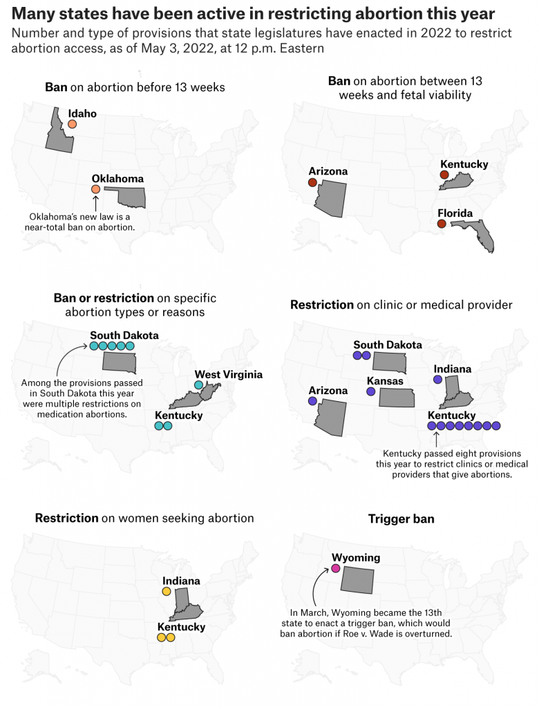
to be overturned by the Supreme Court, as seems likely, states have been busy passing laws to both restrict and expand abortion access. This article from FiveThirtyEight describes the statutory activity with the use of a small multiple graphic I’ve screenshot below.
Too much colour for my liking
Each little map represents an action that states could have taken recently, for example in the first we have states banning abortion before 13 weeks, i.e. a nearly total ban on abortion. It uses dots, for this map orange, to indicate legislative acts to that effect. But if states have passed multiple legislative acts, e.g. South Dakota when it comes to banning specific types or reasons for abortion, multiple dots are used.
I generally like this, but would have liked to have seen an overview map either at the beginning or end that would put all the states together in context. Dot placement, especially for states like Kentucky, would be tricky, but it would go a way to show how complex and convoluted the issue has become at the state level.
Last month, a 2-year old shot and killed his 4-year old sister whilst they sat in a car at a petrol station in Chester, Pennsylvania, a city just south of Philadelphia.
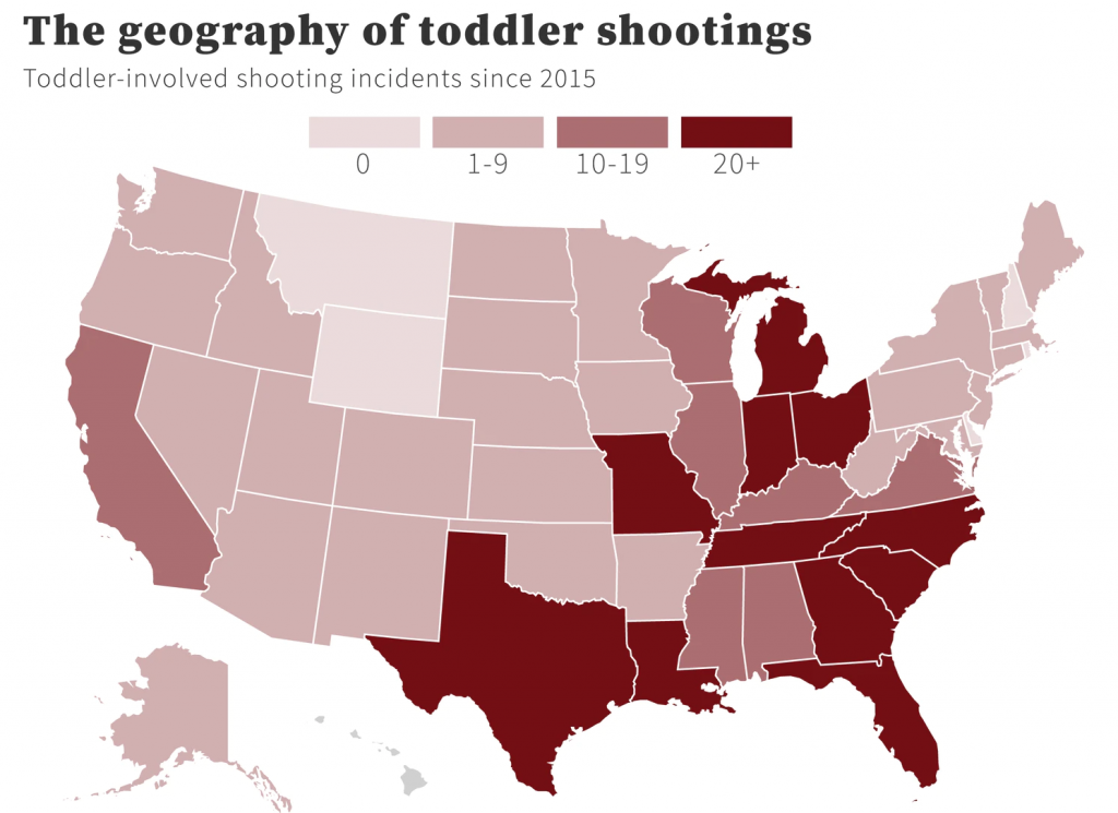
Not surprisingly some people began to look at the data around kid-involved shootings. One such person was Christopher Ingraham who explored the data and showed how shootings by children is up 50% since the pandemic. He used two graphics, one a bar chart and another a choropleth map.
The map shows where kid-involved shootings have occurred. Now what’s curious about this kind of a map is that the designer points out that toddler incidents are concentrated around the Southeast and Midwest. And that appears to be true, but some of the standouts like Ohio and Florida—not to mention Texas—are some of the most populated states in the country. More people would theoretically mean more deaths.
So if we go back to the original data and then grab a 2020 US Census estimate for the under-18 population of each state, I can run some back of the envelope maths and we can take a look at how many under-18 deaths there had been per 100,000 under-18 year-olds. And that map begins to look a little bit different.
If anything we see the pattern a bit more clearly. The problem persists in the Southeast, but it’s more concentrated in what I would call the Deep South. The problem states in the Midwest fade a bit to a lower rate. Some of the more obvious outliers here become Alaska and Maine.
As the original author points out, some of these numbers likely owe to lax gun regulation in terms of safe storage and trigger locks. I wonder if the numbers in Alaska and Maine could be due to the more rural nature of the states, but then we don’t see similar rates of kid deaths in places like Wyoming, Montana, and Idaho.
Credit for the original piece goes to Christopher Ingraham.
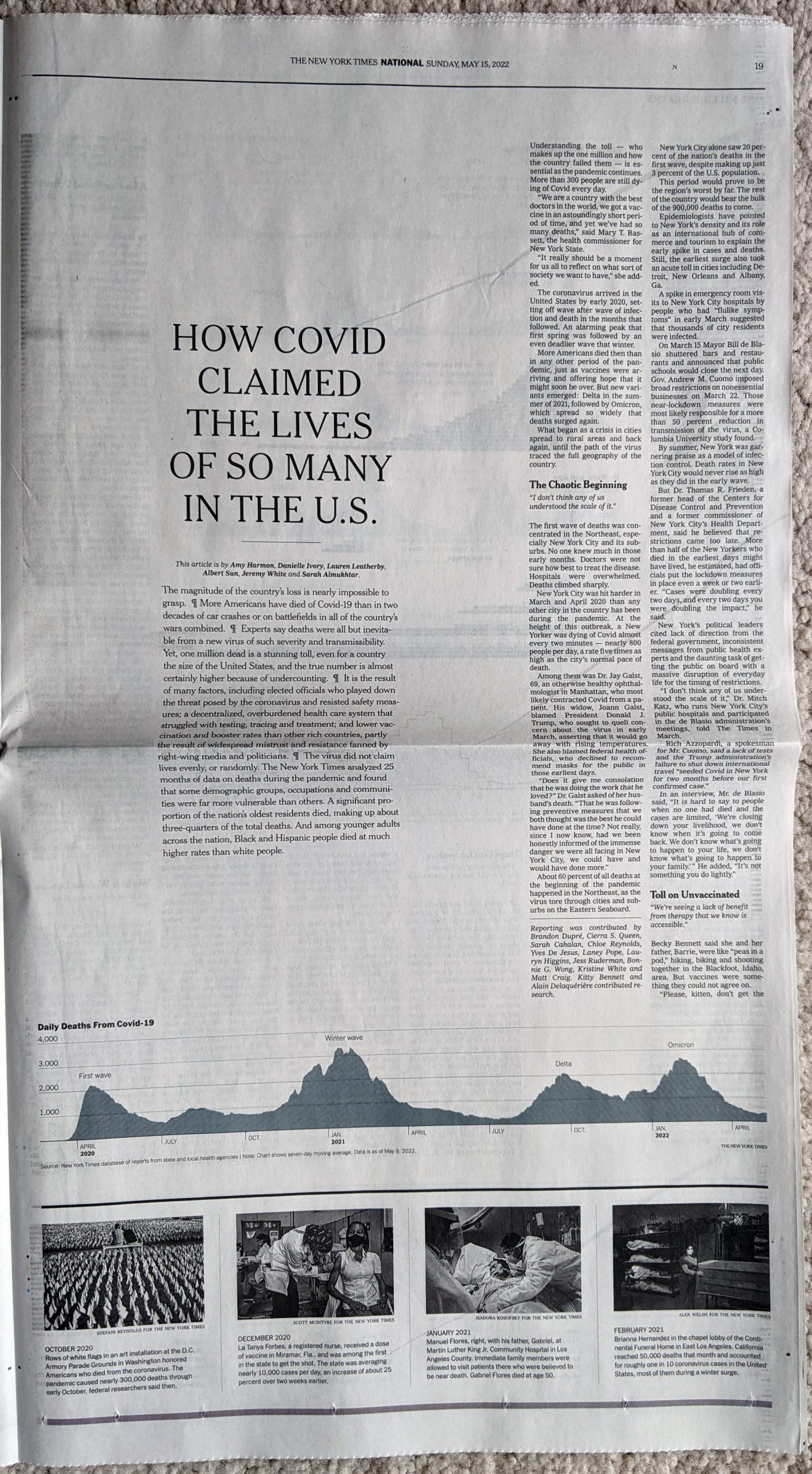
Yesterday I focused on the big graphic from the New York Times that crossed the full spread of the front/back page. But the graphic was merely the lead graphic for a larger piece. I linked to the online version of the article, but for this post I’m going to stick with the print edition. The article consists of a full-page open then an entire interior spread, all in limited colour. The remainder of the extensive coverage consists of photo essays and interviews that understandably attempt to humanise the data points, after all, each dot from yesterday represented one individual, solitary, human being. That is an important element of a story like this and other national and international tragedies, but we also need to focus on the data and not let the emotion of the story overwhelm our rational and logical analysis.
Sometimes it’s hard to realise we’re in the third year of this pandemic.
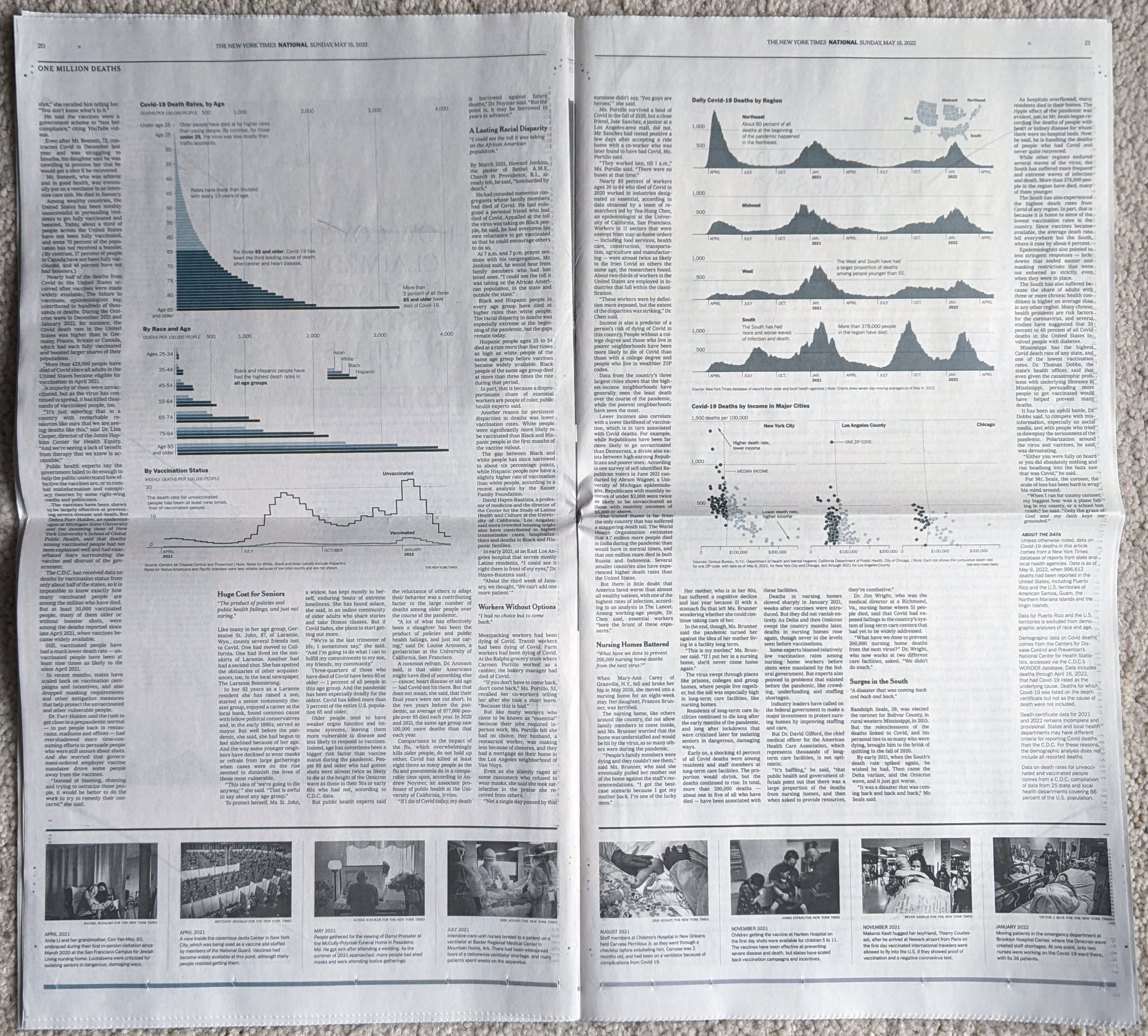
From a data visualisation standpoint the first page begins simply enough with a long timeline of the Covid-19 pandemic charting the number of absolute deaths each day. As we looked at yesterday, the absolute deaths tell part of the story. But if we were to have looked at the number of absolute cases in conjunction with the deaths, we could also see how the virus has thus far evolved to be more transmissible but less lethal. Here the number of daily deaths from Omicron surpassed Delta, but fell short of the winter peak in early 2021. But the number of cases exploded with Omicron, making its mortality rate lower. In other words, far more people were getting sick, but as far fewer were dying.
An interesting note is that if you take a look at the online version, there the designers chose a more stylised approach to presenting the data.
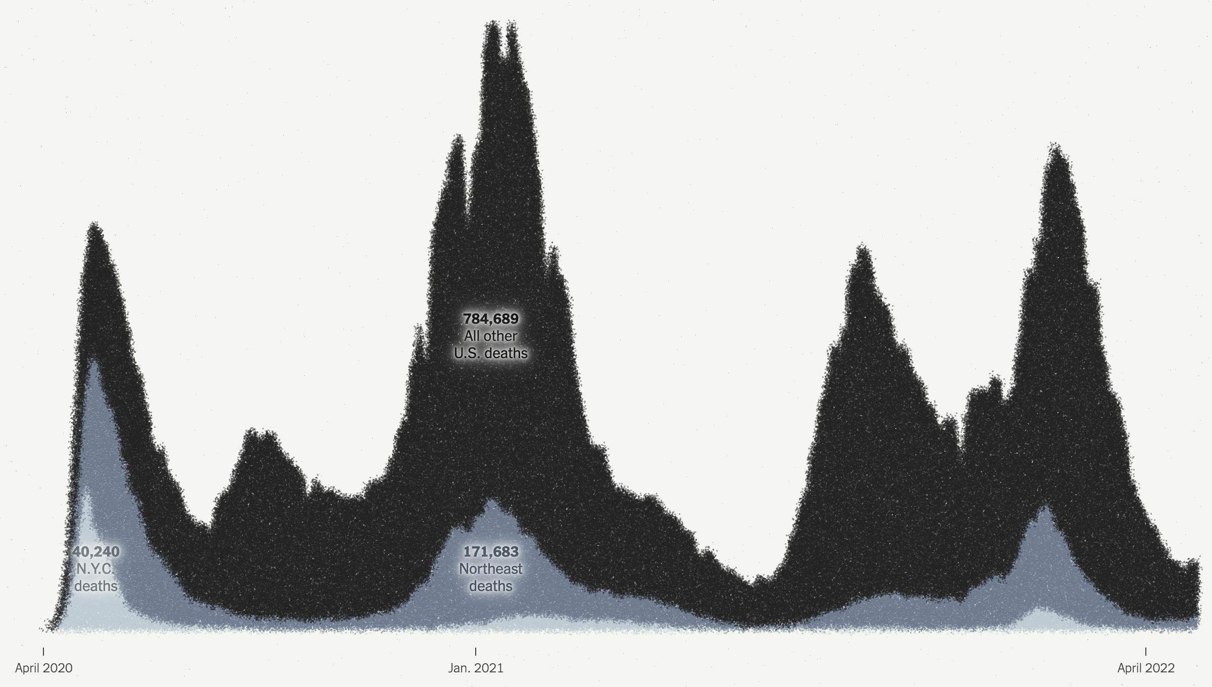
All the dots
Here they kept the dot approach and simply stacked and reordered the dots. However, I presume for aesthetic reasons, they kept the stacking loose dots and dropped all the axis lines because it does make for a nice transition from the map to this chart. But they also dropped all headings and descriptors that tell the reader just what they are looking at. These decisions make the chart far less useful as a tool to tell the data-driven element of the story.
There are three annotations that label the number of deaths in New York, the Northeast, and the rest of the United States. But what does the chart say? When are the endpoints for those annotations? And then you can compare the scale of the y-axis of this chart and compare it to the printed version above. A more dramatic scale leads to a more dramatic narrative.
This sort of visual style of flash and fancy transitions over the clear communication of the data is why I find the print piece more compelling and more trustworthy. I find the online version, still useful, but far more lacking and wanting in terms of information design.
The interior spread is where this article shines.
Just a fantastic spread.
From an editorial design standpoint, the symmetry works very well here. It’s a clear presentation and the white space around the graphic blocks lets that content shine as it should in this type of story. Collectively these pieces do a great job telling the story of the pandemic thus far across the nation. The graphics do not need a lot of colour and make do with sparse flash. Annotations call the reader’s attention to salient points and outliers.
Very nice work here.
From a content standpoint, I would be particularly curious if we have robust data for deaths by education level. Earlier this year I recall reading news about a study that said education best correlated to Covid cases, and I would be curious to see if that held true for deaths. Of course these charts do a great job of showing just how effective the vaccines were and remain. They are the best preventative measure we have available to us.
More really nice graphics
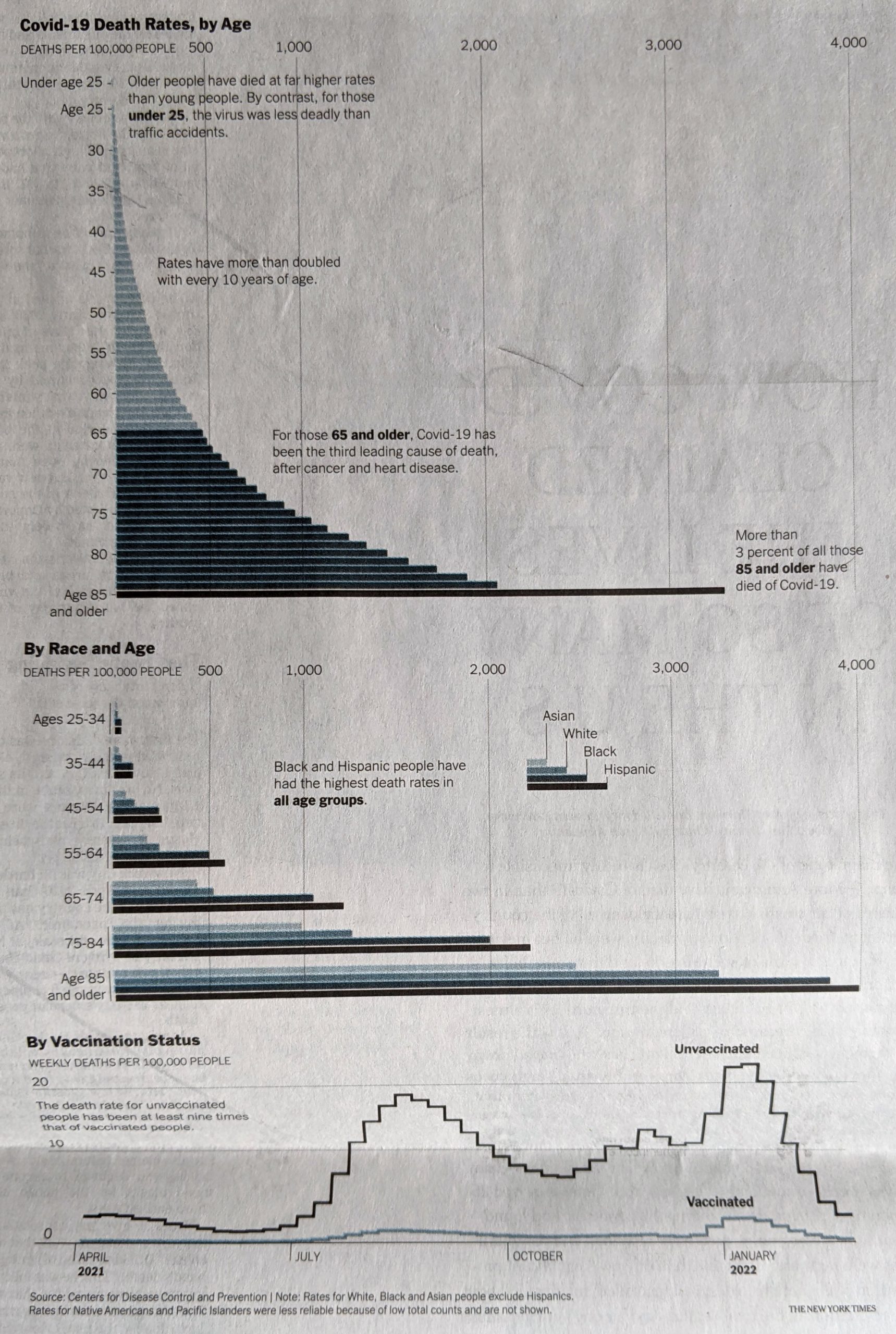
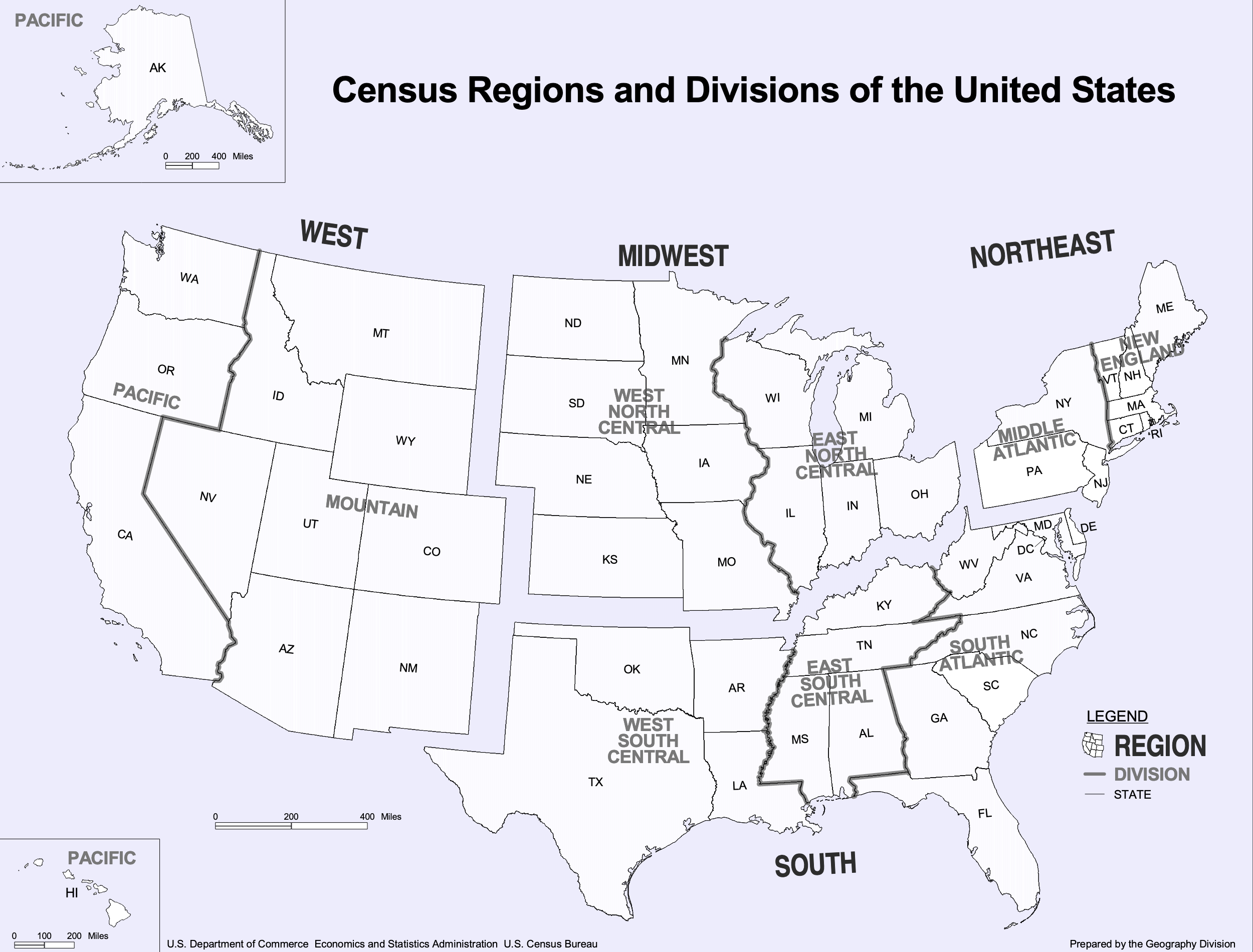
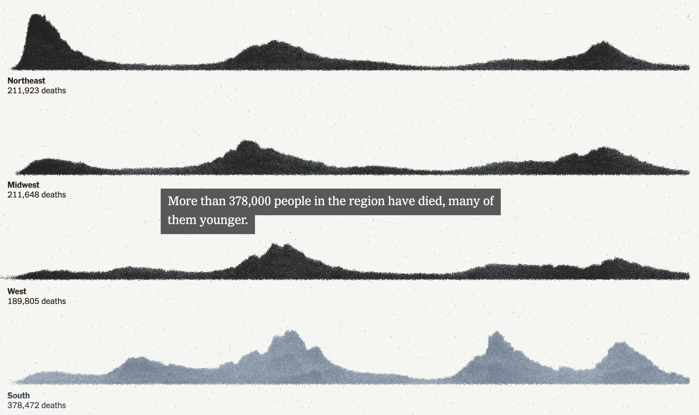
Here I disagree with the design decision of how to break down the states into regions. The Census Bureau breaks down the United States into four regions using the same names as in the graphic above. However, if you look closely at the inset map, you will see that Delaware, Maryland, and West Virginia in particular are included as part of the Northeast. (I cannot tell if the District of Columbia is included as part of the Northeast or South.)
Now compare that to the Census Bureau’s definition:
How the government defines US geography
If you ask me to include Delaware and Maryland as part of the Northeast, well, if you’re selling it, I’ll buy it. After all, just because the Census Bureau defines the United States this way does not mean the New York Times has to. Both are connected to the Northeast Corridor via Amtrak and I-95 and are plugged into the Megalopolis economy. Maybe the Potomac should be the demarcation between Northeast and South. But I struggle to understand West Virginia. Before you go and connect it to the Northeast, I would argue that West Virginia has far more in common with the Midwest geographically, economically, and culturally.
More critically, given this issue, it strikes me as a serious problem when the online version of the chart—with the aforementioned issues—does not even include the little inset to highlight this at best unusual regional definition.
Where would you place West Virginia?
And so while I have reservations about the data—how would the data have looked if the states were realigned?—the design of the line charts overall is good.
Again, I am talking about the print version, not that online graphic. I would argue that the above screenshot is barely even a chart and more “data art” or an illustration of data. Consider here, for example, that for the South we have that muted slate blue for the dots, but the spacing and density of the dots leads to areas of lighter slate and darker slate. But a lighter slate means more space between stacked dots and darker slate means a more compact design. A lighter colour therefore pushes the “edge” of the line further up the y-axis and artificially inflates its value, not that we can understand what that value is as the “chart” lacks any sort of y-axis.
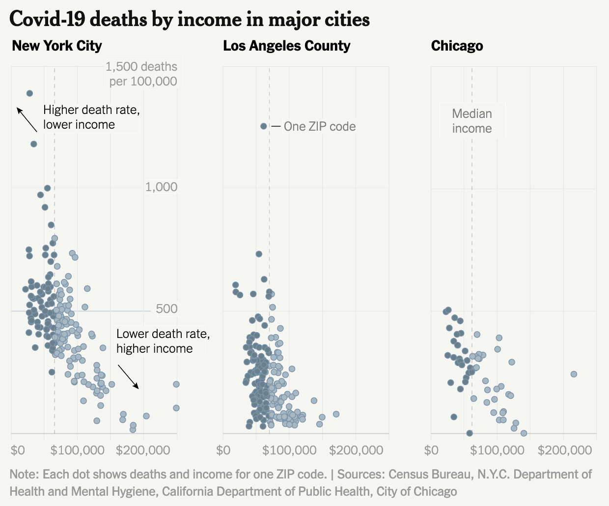
Finally the print piece has a set of small multiples breaking down deaths by income in the three largest American cities: New York, Los Angeles, and Chicago. These are just great little charts showing the correlation between income and death from Covid, organised by Zip code.
But this also serves as a stark reminder of just how much better the print piece is over the online version. Because if we take a look at a screenshot from the online article, we have a graphic that addresses all the issues I pointed out earlier.
Why couldn’t the online article kept to this style?
I am left to wonder why the reader of the online version does not have access to this clearer and more accurate representation of the data throughout the piece?
To me this article is a great example of when the print piece far exceeds that of the online version. Content-wise this is a great story that needed to be told this weekend, but design wise we see a significant gap in quality from print to online. Suffice it to say that on Sunday I was very glad I received the print version.
Credit for the piece goes to Sarah Almukhtar, Amy Harmon, Danielle Ivory, Lauren Leatherby, Albert Sun, and Jeremy White.