Brexit Deal 2.0

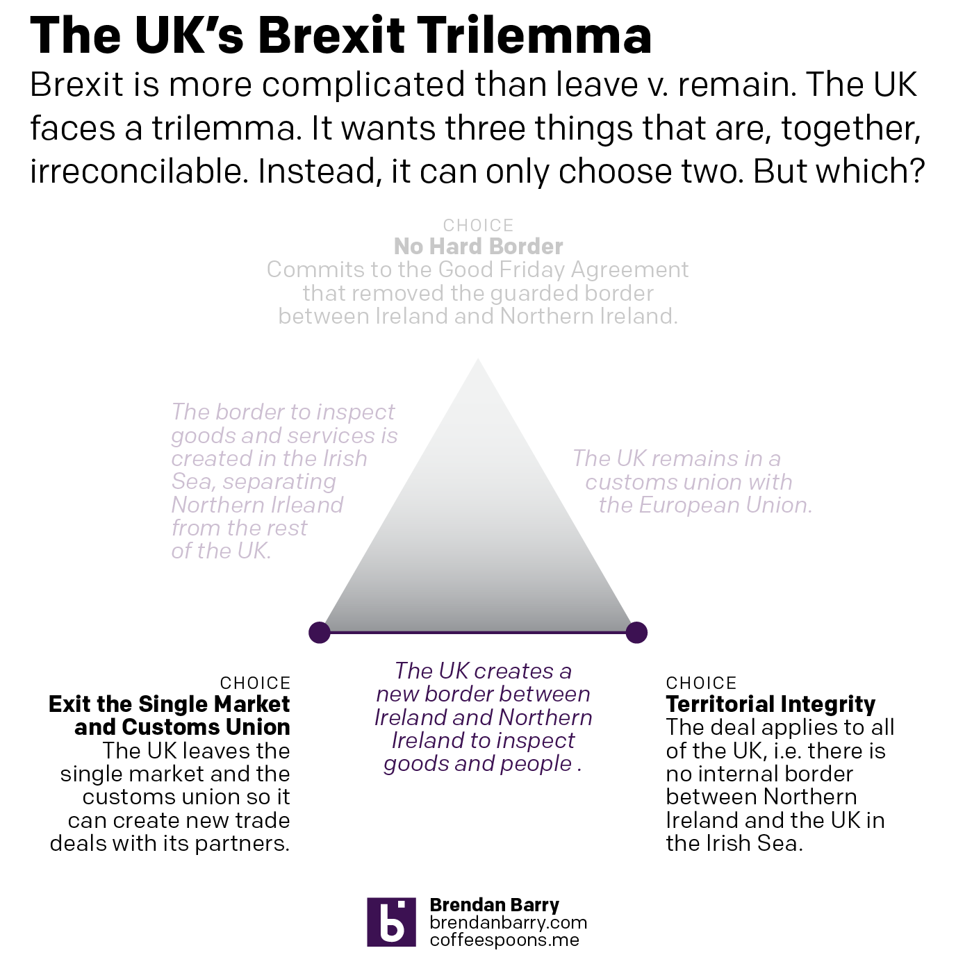
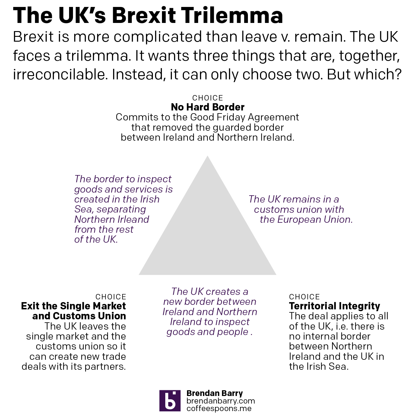
I’ve been trying to work on a Syrian changing alliances graphic, but the Brexit news today scuppered that. Instead, we take a look at Boris’ deal, which differs from May’s in that it chucks out the notion of territorial integrity, creating a border in the Irish Sea where goods will have to be inspected. My old Brexit trilemma graphic shows the new deal’s fundamental choices.

Shifting priorities
Shifting priorities

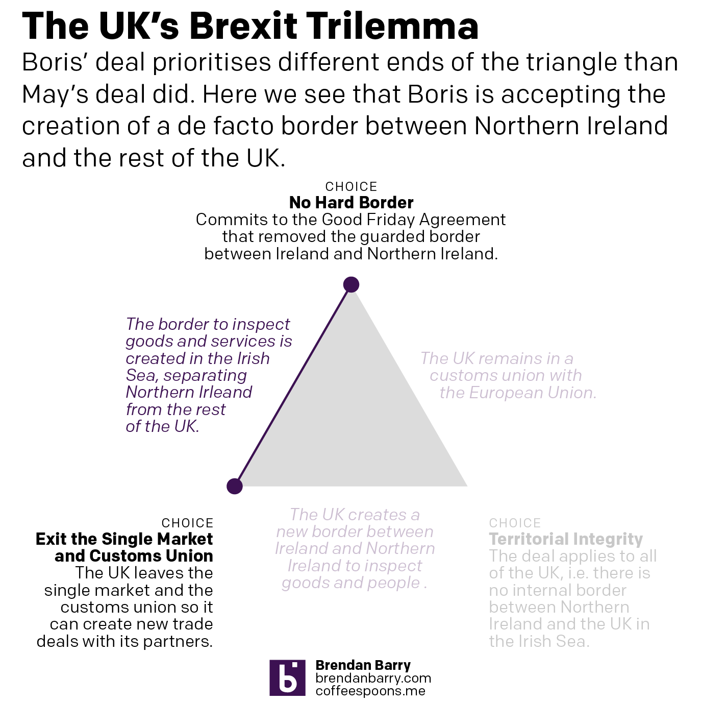
But how does this exiting the customs union and single market work? Well, the whole of the UK is leaving the customs union, but on the single market, there Northern Ireland remains in, aligned to the EU, whereas the rest of the UK is leaving. Ports will screen for some goods to ensure compliance with UK officials ensuring EU standards.

There are still questions about how this will all shake out

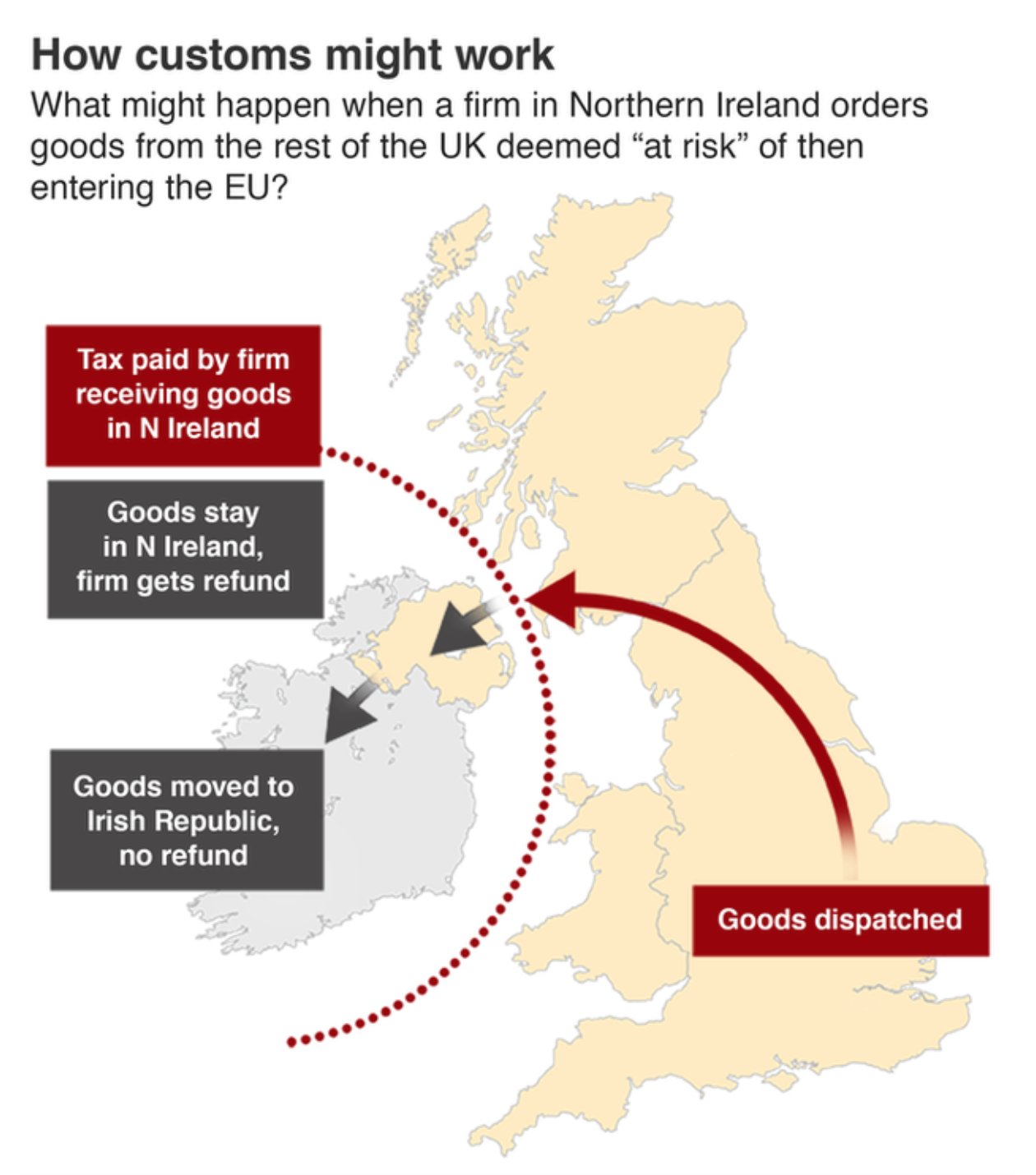
The BBC graphic above is pretty straightforward, showing the new border as a dotted line. But the border is there. There is still quite a bit we don’t know. And most important of those questions is can Boris get his deal through Parliament? Remember, he tossed 20 MPs out of the party. And there are signals that the DUP, a conservative Northern Irish party that provides the crucial backing votes to the Tories to ensure the Tory majority (before, again, Boris kicked out 20 of his own MPs), will vote against the deal because it separates them from the rest of the UK.

Credit for the trilemma is mine.

Credit for the BBC graphic goes to the BBC graphics department.

Brexit Trilemma Update

This week is the Conservative Party Conference in Manchester where the Tories unveil their government programmes and platforms. Naturally it has been overshadowed by allegations that Boris Johnson groped one (maybe two) reporters at a dinner in 1999. Just prior to that scandal, however, there was another. In this, Johnson was allegedly having an affair with an American businesswoman for whom he then arranged lucrative business deals whilst in office as the Mayor of London. Johnson has been referred to a police unit for further investigation in that matter. Sounds like some, you might say, golden parallels to…someone or something.

But today’s big news about the government’s plans is that they might have one regarding Brexit. And that plan is to essentially create a hard border between Northern Ireland and Ireland, violating certainly the spirit if not the letter of the Good Friday Agreement that brought the end to the Troubles.

Why is this a big deal? Well, one, remember all the debates during the Brexit Referendum campaign about the Irish border, how the different groups had different solutions to this fundamental problem?

Oh wait, yeah, nobody ever brought this up. Sorry.

So back to my trilemma graphic. I’ve updated it to show which two sides of the triangle Boris Johnson seems to be choosing. To be fair, as I’ve said many times, the UK cannot have all three points of the triangle. They need to pick two. And so, unlike Theresa May, Johnson is at least picking two. My problem is that this was never discussed during the Brexit debates and it seems a rather drastic decision to not have it be confirmed by the people since they never explicitly voted on it.

You may not like it, but at least Johnson is picking sides…

Credit for the graphic is mine.

The Trilemma Remains for Boris

This is a repost of sorts, but it is important. Now prime minister, Boris Johnson had an opportunity to seek a more reasonable approach to Brexit. Unfortunately, he is drawing even harder red lines than his predecessor, Theresa May. And that brings us back to my Brexit trilemma graphic from back in March.

Essentially, Johnson wants three things that are mutually—or whatever the word is for three, maybe tri-mutually—semi-exclusive. In other words, of the three red lines, the United Kingdom can only have two, because those two then make the third impossible.

Doing the same thing but expecting results…pick two already, Boris.

I made the first version of this back in March. Sad it still applies.

Credit for the piece goes to me.

British English vs. Irish English

The United Kingdom is known for having a large number of accents in a—compared to the United States—relatively small space. But then you add in Ireland and you have an entirely new level of linguistic diversity. Josh Katz, who several years ago made waves for his work on the differences in the States, completed some work for the New York Times on those differences between the UK and Ireland.

You might know this as tag. At least I do.

Why do I bring it up? Well, your author is going on holiday again, this time back to London. I will be maybe taking some day trips to places outside the capital and maybe I will confirm some of these findings. But if you want, you can take the quiz and see where you fall compared to Katz’s findings.

And it does pretty well. It identified me as being clearly not from the British Isles.

Maybe I'm secretly Cornish?
Maybe I’m secretly Cornish?

But depending upon how you answer a particular question, the article will show you how your answer compares.  Let’s take my answer for scone. In that, I am more Irish.

Or you can just call them fantastic and delicious.

Credit for the piece goes to Josh Katz.

Demanding the Impossible

The key problem in the Brexit deal remains what to do with the Irish border. In essence, the UK faces the same trilemma it has since the beginning. It wants three things it cannot have at the same time: exiting the EU single market and customs union, so it can create a free and independent trade policy; no hard border between Ireland and Northern Ireland, per the Good Friday Agreement that ended the Troubles; and territorial integrity, i.e. no hard border between Northern Ireland and the rest of the UK in the Irish Sea.

Essentially, the UK can choose two of these three options. Below, I have attempted to show how they relate and what the result is once two of the options have been chosen.

Choose two and only two.

Credit for the piece is mine.

Brexit’s Impact on Irish Shipping

Today’s post is, I think, the first time I’ve featured the Politico on my blog. Politico is, I confess, a regular part of my daily media diet. But I never thought of it as a great publication for data visualisation. Maybe that is changing?

Anyway, today’s post highlights an article on how the Irish shipping/logistics industry could be affected by Brexit. To do so, they looked at data sets including destinations, port volume, and travel times. Basically, the imposition of customs controls at the Irish border will mean increased travelling times, which are not so great for time-sensitive shipments.

This screenshot if of an animated .gif showing how pre-Brexit transit was conducted through the UK to English Channel ports and then on into the continent. Post-Brexit, to maintain freedom of movement, freight would have to transit the Irish Sea and then the English Channel before arriving on the continent. The piece continues with a few other charts.

Brexit strikes again

My only question would be, is the animation necessary? From the scale of the graphic—it is rather large—we can see an abstracted shape of the European coastlines—that is to say it’s rather angular. I wonder if a tighter cropping on the route and then subdividing the space into three different ‘options’ would have been at least as equally effective.

Credit for the piece goes to Politico’s graphics department.

Brexit and Ireland

This week I really wanted to hold off on commenting about Brexit graphics until things settled down—admittedly thinking Remain would win. Now that Thursday has arrived, I think we can all agree that settling down is not happening and the UK really is leaving the EU.

As an Irish American, I grew up with frequent commentary about the Troubles and the general situation in Ireland. So by dint of my heritage, I care about how Brexit impacts Northern Ireland. Unfortunately this graphic from the New York Times on Brexit sentiments entirely omitted Northern Ireland. (It is far from the first time graphics about the UK omit Northern Ireland.)

Where is Northern Ireland?

But, what irritates me in particular about this graphic at this historic time, is what the designers did choose to include. If you look to the north and west of Scotland, you will find the Outer Hebrides and Orkney Islands. From the legend it appears there are no results, accordingly the islands remain—pun intended—grey for, I presume, a classification of not applicable or something similar. (Although, that should also be clarified in the legend.) But, while we are given an inset of Greater London’s results, the entire home nation of Northern Ireland is omitted from the results. (I could then mention how Northern Ireland was not ignored when it came to the Euro 2016 Round of 16 participant results, but I do not understand football enough to comment intelligently.)

And since we mentioned Northern Ireland, we should also mention that Gibraltar is absent from the results map presented here. Gibraltar was once Spanish territory. However, Spain ceded it to the United Kingdom in 1713 as part of the Peace of Utrecht made to end the War of the Spanish Succession. Gibraltar voted overwhelmingly to Remain. And as with Scotland and Northern Ireland, it will (likely) be dragged out of the EU against its people’s wishes.

Credit for the piece goes to the New York Times graphics department.