Philadelphia’s Changing Skyline

Yesterday I mentioned how I spent Monday researching some old family properties in Philadelphia. In some cases the homes my family owned still stand. But, in many others the homes have long since been replaced. But that’s the nature of city development.

That got me thinking about an article published earlier this month at Philadelphia YIMBY where the author created an animated .gif detailing the Philadelphia skyline from 1905 through 2020. This screenshot captures the overlay of 2020 atop 1905 from the south of Philadelphia.

Kind of how it’d look from the sports complex.

But the gem of the piece is the animation. Implicit in the graphic but unmentioned is the text, which is understandably centred on the architectural designs of the skyline, is the history of Philadelphia.

In the old days, well before 1905, the city was concentrated along the Delaware River because it was—and still is—a port city. But as those shipping businesses were replaced by banks and financial companies which were replaced by other offices and manufacturing headquarters that were themselves replaced by corporate highrises and so on and so forth, we can see the centre of gravity shift westward.

The mass of buildings by 1905 has shifted away from the Delaware River and is concentrated to the east of City Hall, the tallest building until the 1980s. But you can see the highest and largest buildings moving more to the left in every frame. Though in the latest you can see some new largely residential highrises built along the Delaware waterfront.

It’s a great piece.

Credit for the piece goes to Thomas Koloski.

The Sartorial Trump

Happy Friday, all. We made it to the end of the week. Though if you are like me, i.e. living on the East Coast, welcome to Hell. As in so hot and humid.

So last month President Trump visited the United Kingdom on a state visit. He drew attention to himself not just because of his rhetoric, but also for his fashion choices. Consequently, the Washington Post published a piece about those fashion choices from the perspective of a professional tailor.

Look at those shoulders…

The overall piece is well worth a read if you find presidential fashion fascinating. But how does it qualify for Coffeespoons? A .gif that shows how Trump would look in a properly tailored suit.

Since this is a screenshot, you miss the full impact. The piece is an animation of an existing photo and how that then morphs into this for comparison’s sake.

I really enjoy the animated .gif when it works for data visualisation and story-telling.

Credit for the piece goes to Ezra Paul.

Brexit’s Impact on Irish Shipping

Today’s post is, I think, the first time I’ve featured the Politico on my blog. Politico is, I confess, a regular part of my daily media diet. But I never thought of it as a great publication for data visualisation. Maybe that is changing?

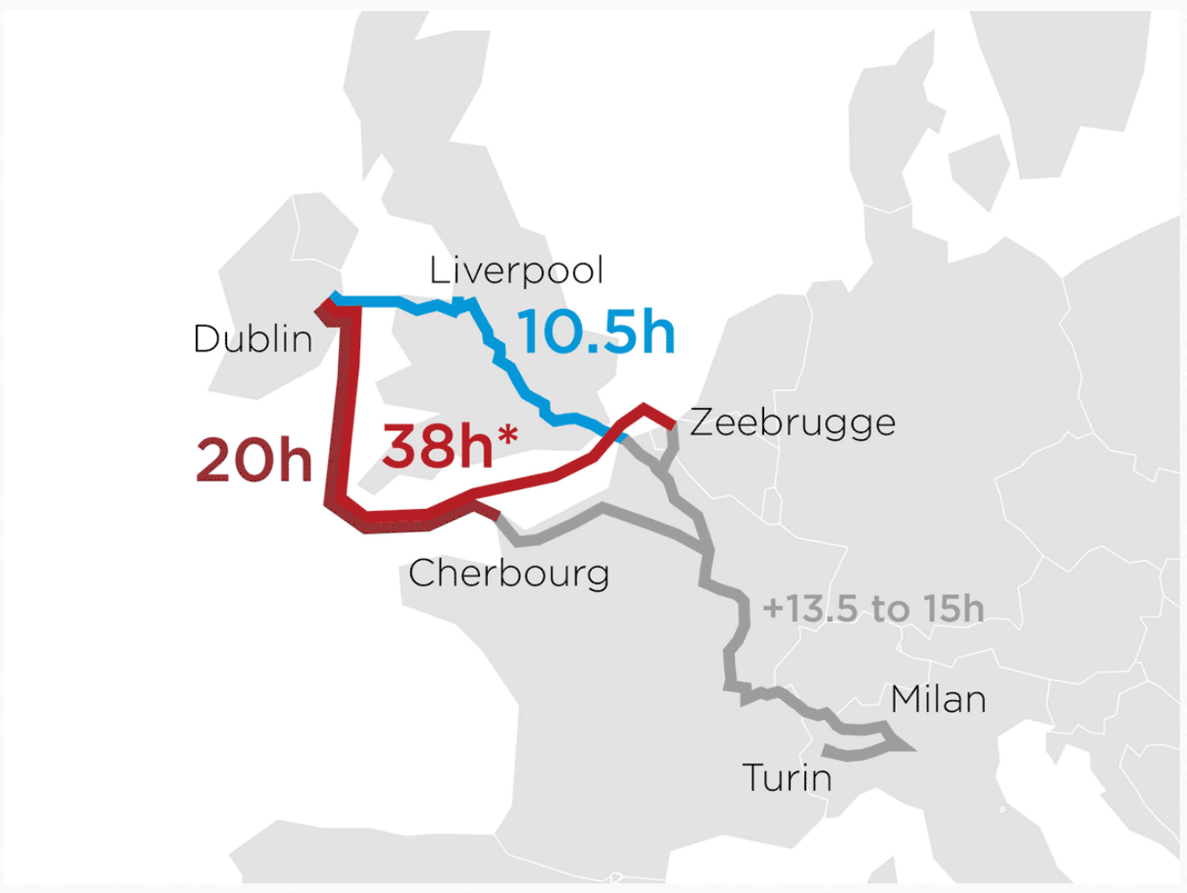
Anyway, today’s post highlights an article on how the Irish shipping/logistics industry could be affected by Brexit. To do so, they looked at data sets including destinations, port volume, and travel times. Basically, the imposition of customs controls at the Irish border will mean increased travelling times, which are not so great for time-sensitive shipments.

This screenshot if of an animated .gif showing how pre-Brexit transit was conducted through the UK to English Channel ports and then on into the continent. Post-Brexit, to maintain freedom of movement, freight would have to transit the Irish Sea and then the English Channel before arriving on the continent. The piece continues with a few other charts.

Brexit strikes again

My only question would be, is the animation necessary? From the scale of the graphic—it is rather large—we can see an abstracted shape of the European coastlines—that is to say it’s rather angular. I wonder if a tighter cropping on the route and then subdividing the space into three different ‘options’ would have been at least as equally effective.

Credit for the piece goes to Politico’s graphics department.

Philly Falls from Fifth

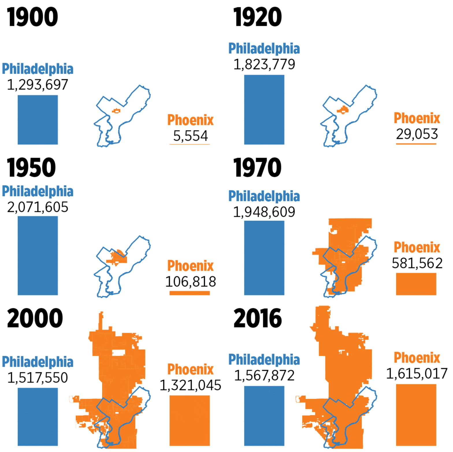
Well it finally happened. While the Great Recession spared Philadelphia for several years, Phoenix has finally moved up into the rank of fifth-largest city in the United States.

There are some notable differences that this graphic captures. The big one is that Philly is relatively small at 135 square miles. Phoenix is half the size of Rhode Island. What the graphic does not capture, however, is that Philly is still growing, albeit more slowly than southern and western cities. Because also in the news is the fact that Chicago has shrunk and lost people. Personally I count as a -1 for Chicago and a +1 for Philly.

Comparing size and population

Credit for the piece goes to the Philly.com graphics department.

Philadelphia’s Growth Since the 1940s

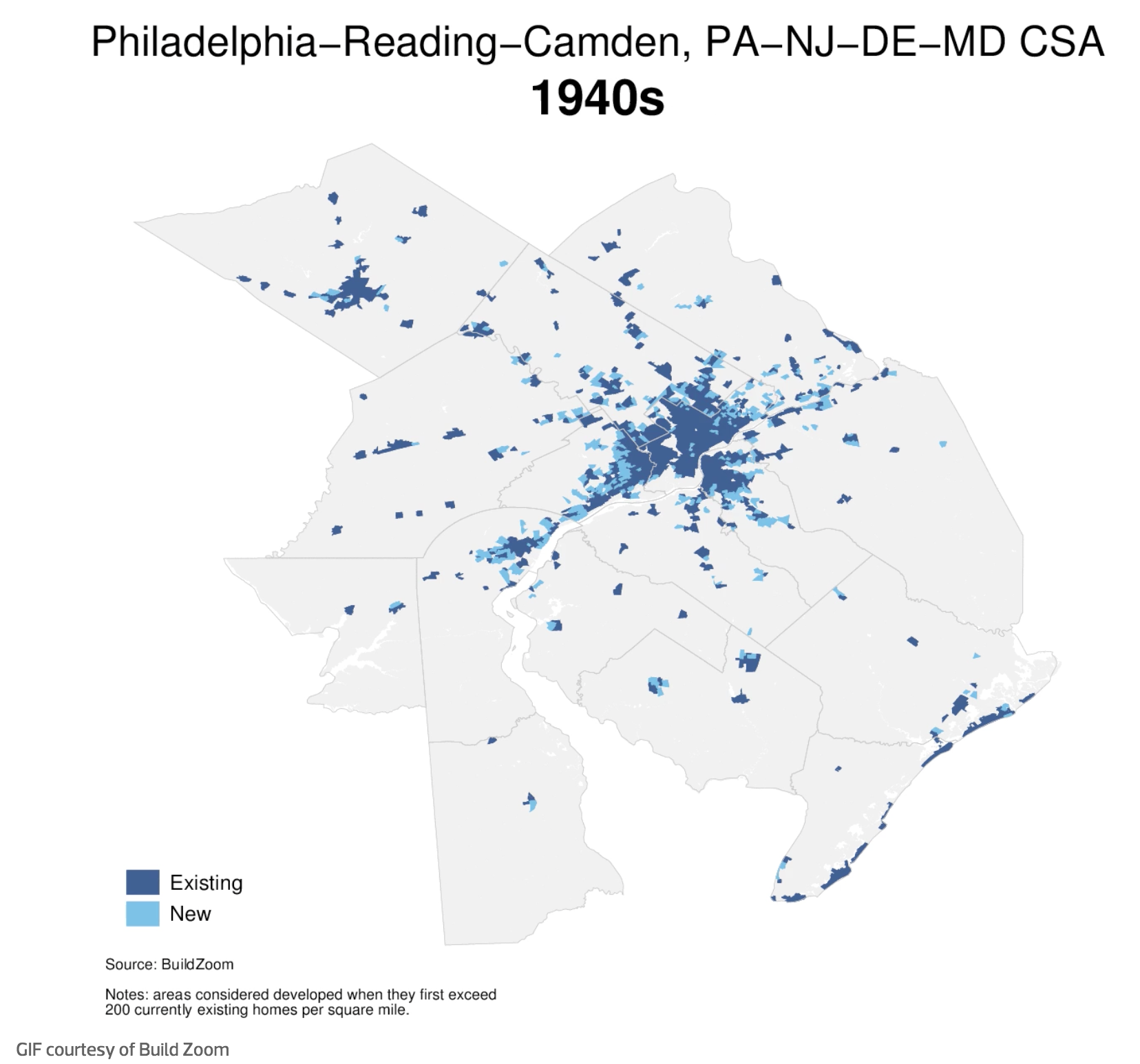
I stumbled upon this article last night on philly.curbed.com that takes a look at the growth and slowdown in said growth in Philadelphia. For the purposes of this blog, that included an animated .gif that showed the expansion in the metro area since the 1940s.

At this point I was far from being born…let alone living in the city

My quibble with the piece is that the lighter blue loses out to the darker. And so one really sees the presence of the city at the expense of the growth. I wonder if reversing the two colours or in some other way de-emphasising the areas built up would allow the new growth areas to come to the forefront of the map.

Credit for the piece goes to BuildZoom.