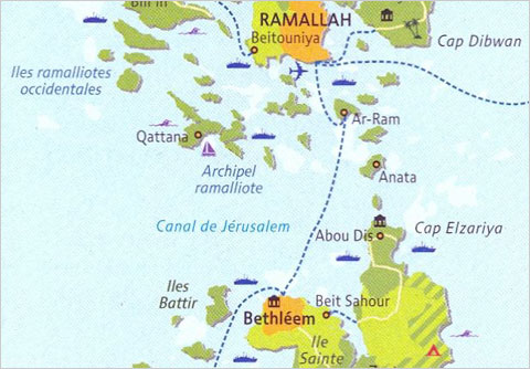
This post is about an older work from Le Monde, the link to which I now forget. However, given all the talk these days about Israel and Palestine and 1967 borders, I figured it may well be advantageous to remind all that the borders likely will not be those of 1967, for the sheer fact that Israel has divided the West Bank between security zones and settlements. The end result is that the Palestinian areas of the West Bank now resemble more an archipelago nation better suited for the islands of Indonesia or the Caribbean rather than the desert of the Middle East.
This link takes you to a New York Times blog post about the land problem and includes the map, which one can see at a reduced scale down in the article.

Credit for the original goes to Julien Bousac of Le Monde.

One thought on “The West Bank Archipelago”