One of the most debated questions one could ask at pub trivia: How many countries are there in the world?
To start, the question cannot be answered completely. What is a country? What is a state? What is a nation? Define recognition. Whose definition?
When I worked at Euromonitor International I had to edit a map for a Moroccan client because the maps and visualisations I designed showed Western Sahara as a disputed and occupied territory along with places like—surprise, surprise—the Gaza Strip and the West Bank, Kashmir, and in later years Abyei. The client was upset because Morocco occupies the majority of Western Sahara, particularly the coast and areas containing the area’s natural resources, and claims it to be an integral part of the kingdom. But the Polisario Front occupies the remainder of Western Sahara and claims the whole territory for its people. Some countries, particularly in Africa, recognise Western Sahara as independent—it belongs as a full member of the African Union. The rest of the world largely refuses to recognise Western Sahara as independent whilst also refusing to recognise Morocco’s occupation. Hence my maps.
You can see what I mean if you look closely at this un-Moroccanised map my team made. I have added some orange boxes to highlight Western Sahara along with the West Bank and Gaza, Abyei, and Kashmir. (Some geographies were simply not covered by the company and remained blank. Here the most notable example is Greenland.)
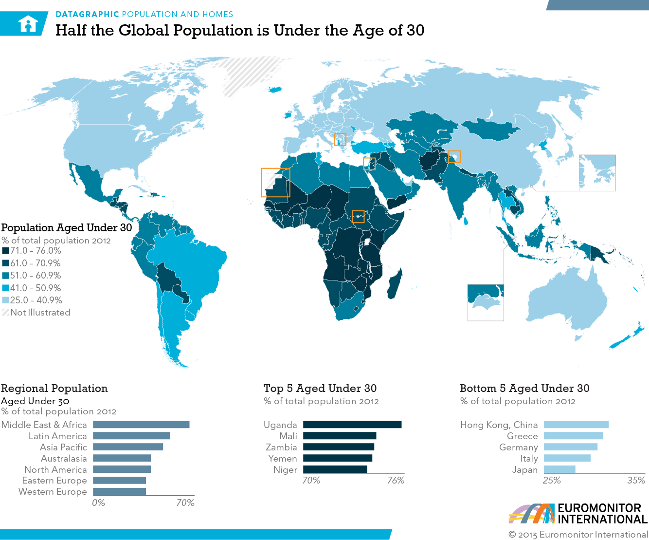
Do you count Western Sahara as a country?
At your pub trivia this week, will you count Palestine as a country?
This past weekend, the United Kingdom, Canada, Australia, and Portugal formally recognised Palestine statehood. They were followed this week by France, Belgium, Luxembourg, Andorra, San Marino, and Malta. (Maybe.) Notably, but not surprisingly, Israel and the United States refuse to follow suit.
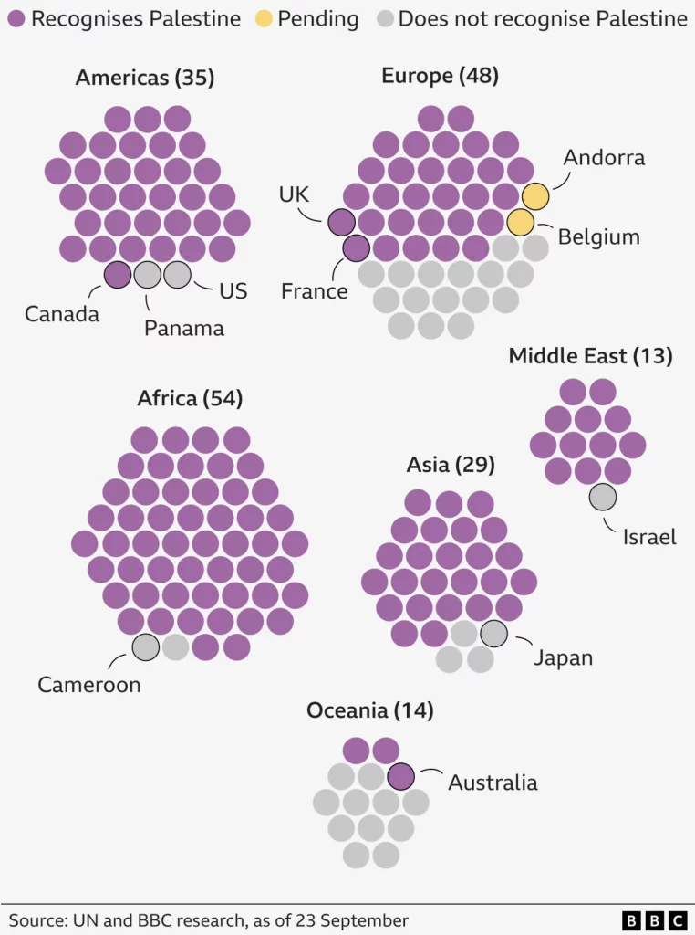
My first draft of this post then continued with a history of the Israel–Palestine conflict from the most recent/today’s war to the formation of Israel to the Ottoman Empire and ancient history. But I wanted this post to focus on these graphics posted by the BBC. The first comes from earlier this week, prior to said announcements. The second from later.
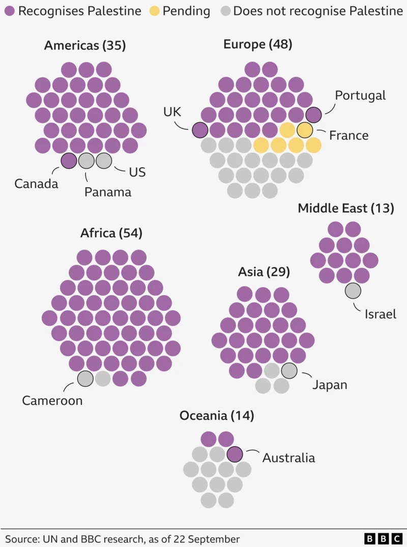
I like this graphic. The designer chose to use circles as abstractions of countries rather than a more traditional choropleth map coloured by who recognises whom. In the context of an international conflict over geographic borders and statehood, removing the concept of borders shows a subtle attention to the nuances of the debate.
Critically, the yellow may be a touch light vís-a-vís the grey, but it clearly stands in stark contrast to the purple. I should note I saved this graphic from earlier this week before the official announcements of France et al. Today all that yellow is solidly purple.
As you can see in this second graphic, most of the yellows have become purples. Any of concerns over the lightness of the yellow faded.
Earlier I had noted how Belgium and Andorra were part of President Macron’s announcement, however this graphic shows them still awaiting to announce. I wonder if the discrepancy will be resolved when the representatives of the those countries speak at the United Nations. In essence, they have pledged to announce their recognition, but will do so formally in their address to happen later.
Once again, graphics need not be overly complicated or complex to clearly explain a point to the audience. You can easily see most of Africa, the Americas, Asia, and the Middle East recognises Palestine. Europe and Oceania remain the outliers at a regional level. But the use of a black stroke to outline the grey dot of the United States makes clear one point. Whilst the use of dots abstracted countries to discrete data points equal in theory, in practice not all dots are equal.
Credit for the piece goes to the BBC graphics department.