Cancelling the Mistral

In a piece of big news about Ukraine yesterday, the French government announced that it was halting the completion of the sale of two Mistral warships to Russia. The first such ship, the Sevastopol (yes, named after said city in Crimea), was due to be delivered in just over a month’s time. The two ships (the other named Vladivostok) would have given Russia the ability to launch amphibious invasions. The reason why this action was not taken earlier? Jobs. The construction of the two ships in French shipyards are a boon to the French economy. But after the recent “incursion” of Russian troops into Donetsk and Luhansk, Paris ultimately reconsidered the deal.

The Wall Street journal provides the graphic illustrating just how potent one of the ships would be.
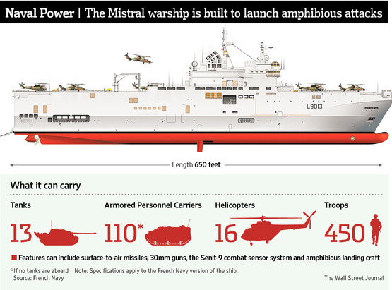
Mistral design
Mistral design

Credit for the piece goes to the Wall Street Journal graphics department.

What Else Has Been Shot Down in Ukraine

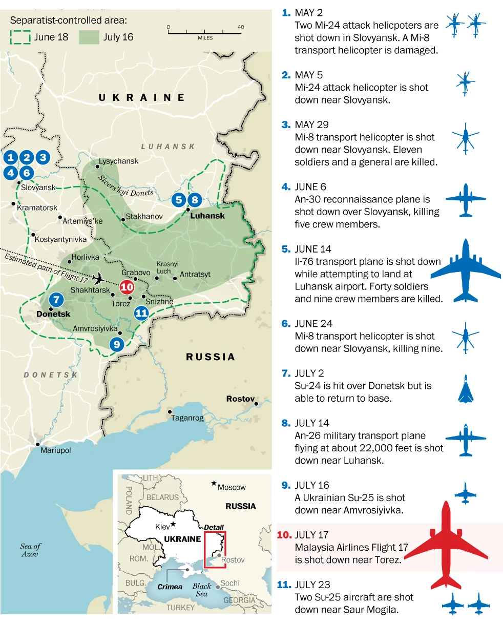
The Boeing 777 jetliner was not the first nor even at this point the latest aircraft shot down over eastern Ukraine. Just yesterday, two Sukhoi Su-25 aircraft were shot down—the Ukrainian government claims from medium-altitude surface-to-air missiles fired from within Russia. While I was working on drawing something up to catalogue just what has been shot down, I stumbled upon this piece from the Washington Post that does just that.

Planes shot down by the separatists

Credit for the piece goes to Gene Thorp.

Restricted Airspace

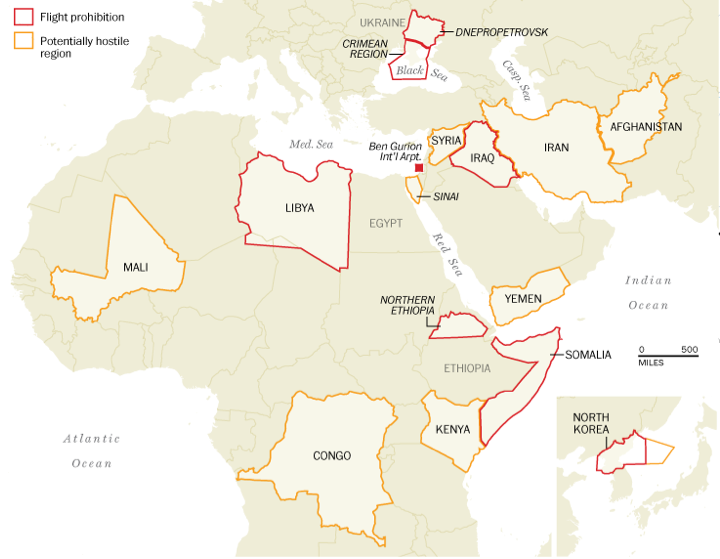
One of the questions in the wake of last week’s shoot down of Malaysia Airlines Flight 17 is why was the aircraft even flying over eastern Ukraine? Generally speaking, because it was not banned from doing so. In today’s graphic, the Washington Post takes a look at those areas that the United States’ Federal Aviation Administration (FAA) restricts flights or warns against travel due to hostile threats, e.g. war. Also note that the Post has included Ben Gurion Airport, which is still under the 24-hour period ban because of a Hamas rocket landing a mile away from the airport in Tel Aviv, Israel.

FAA restriction areas

Credit for the piece goes to Katie Park, Kevin Schaul, and Gene Thorp.

The Air Defence Systems of Eastern Ukraine

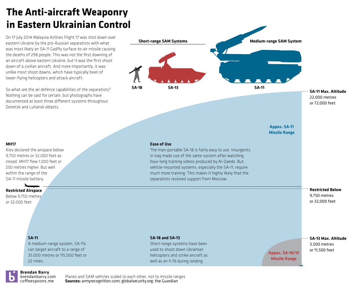
Last week, separatists in eastern Ukraine shot down Malaysia Airlines Flight 17 with what appears to have been an SA-11 Gadfly missile. Separatists had previously claimed to have had this system in operation and days earlier shot down a high-altitude Ukrainian military aircraft—though not necessarily with the SA-11. How much more powerful is the SA-11 than the other two known surface-to-air missile systems the separatists have used to shoot down Ukrainian military helicopter and aircraft? Well, I decided to create a small graphic to show you that the SA-11 is a significant advancement over the shorter range systems in use up to now.

Eastern Ukrainian SAM systems

Malaysia Airlines Flight 17

Talk about an airline with bad luck this year. Malaysia Airlines—yes of the missing flight in the Indian Ocean fame—lost another aircraft yesterday as separatists in eastern Ukraine allegedly shot it down with an SA-11 Gadfly surface-to-air missile. For those unaware, that is a much more deadly and capable system than the shoulder-launched missiles separatists have been using to shoot down Ukrainian aircraft. (In my non-expert opinion, the separatists probably thought they were doing just that, shooting down a Ukrainian transport plane.)

In short, there is quite a bit going on in eastern Ukraine today. Thankfully we have the New York Times creating a page of maps to explain the shoot-down of MH17.

Not all airlines have flown over Ukraine

Credit for the piece goes to the graphics department of the New York Times.

Where the Rebels are in Eastern Ukraine

Today’s piece is far from ground-breaking or even complex. Friday, the Wall Street Journal published this map to supplement an article about the unilateral ceasefire declared by President Poroshenko in Ukraine. The map highlights the areas effectively controlled by the rebels, the most important the unsecured border. Of course this is just a map as stated by Kiev, the reality on the ground might be different. Regardless, it is the first map I have seen that has actually tried to demarcate the territory actually under control rather than claimed.

Rebel-held territory in eastern Ukraine

Credit for the piece goes to the Wall Street Journal’s graphics department.

Ukrainian Unity

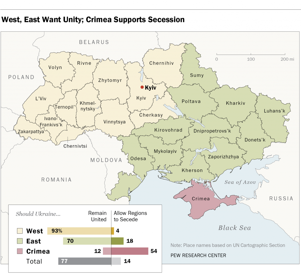
In the votes held this past weekend, the separatists in Donestk and Luhansk claim they received a mandate for independent states. However, according to polls conducted by Pew a few weeks back, most of Ukraine, with the notable exception of Crimea, wants to remain united as a single country. In fairness, this poll was conducted after Russia annexed Crimea but before the deaths of pro-Russian separatists in Odessa and Mariupol. (Anecdotally, those events have driven some to the separatist camp.) The map below is part of the Pew report. However, I have an issue with it that, again in fairness, might not be solvable given whatever raw data with which Pew was working.

Who wants secession? Only Crimea.

The map colours each oblast, roughly equivalent to a US state, according not to the results of the survey, but rather to which region the oblast belongs. For example, Kirovohrad is the same colour as Donetsk. Donetsk, however, is the epicentre of the unrest in Ukraine whereas I have at least seen no reports of unrest in Kirovohrad. Are they really reporting the same desire of unity or secession? Would the map not be clearer if each oblast was reported independently?

My guess is that results like these are clear to the Kremlin. And so I think while Donetsk and Luhansk will remain Ukrainian, Crimea will likely remain Russian.

Credit for the piece goes to the Pew Research Center’s graphics department.

Comparing the Troop Deployments of Russia and Ukraine

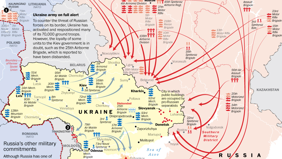
Things remain tense in Ukraine, especially after the violence late last week in Odessa. But in many senses, Ukraine is limited in the operations it can undertake against the separatists, at least with its armed forces. A lot of this has to do with the tens of thousands of Russian troops, tanks, and aircraft now deployed along the border. Thankfully the Washington Post has taken the time to detail just what is known to have happened lately.

The buildup along the Russian–Ukrainian border

Credit for the piece goes to Gene Thorp.

NATO Deployments Near Ukraine

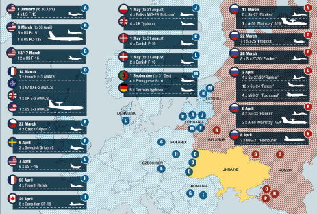
Things continue to deteriorate in eastern Ukraine. And along the other borders of Ukraine, NATO is boosting its presence with planes, ships, and soldiers. This graphic from Jane’s details the recent deployment of aircraft to the theatre.

NATO's deployments
NATO’s deployments

Credit for the piece goes to IHS Jane’s Defence Weekly.

Answering Some More Questions About Ukraine

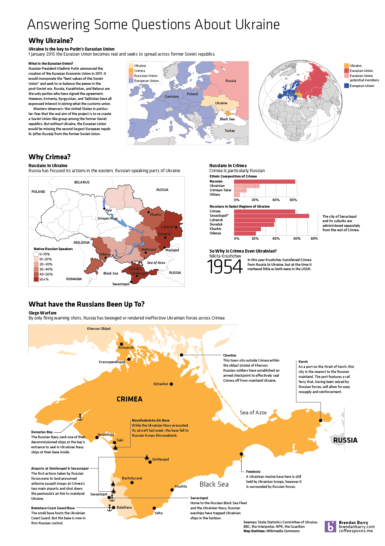
So Ukraine is even more of a mess and in less than a week’s time, the Crimean people will vote in a referendum on whether they want to remain a part of Ukraine or rejoin Russia. This graphic of mine is an attempt to answer some questions—though hardly all I wanted—about Ukraine, Crimea, and about what the Russians have been doing. (To be fair, the Russians still don’t admit that the troops and soldiers are theirs. But really, I mean come on, we all know they are.)

Why Crimea?
Why Crimea?