If Kites Could Fly to the Future, What Would They Find?

If only Benjamin could see this…

The Control Room
The Control Room

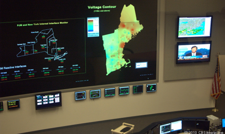
These are photographs from a small series published by CNET that focuses on a power grid control room. As one can imagine, managing the flow of electrical energy across somewhere the size of New England could be a bit…complicated. And so one can see from some kind of network map (perhaps?) on the main display. At the very least I can make no sense of it.

Voltage Map (right) and Monitor of Neighbouring Power Grid (left)
Voltage Map (center) and Monitor of Neighbouring Power Grid (left)

On the other hand, I only wonder what would happen if Homer were sitting behind a bank of those monitors?

Photographs by Martin LaMonica, CNET

Won’t You Be My Neighbour

The BBC has an article about the massiveness of Facebook—at least in the United States. They have taken the data and spent time to do a little bit of visualisation. It is worth a look; the design is not perfect but acceptable in a broad sense.

Social Networking Usage

Poor MySpace.

The Name’s Bond…

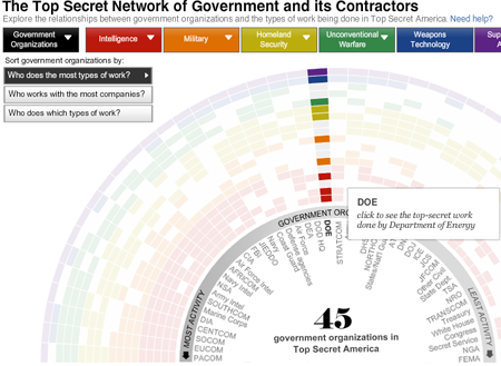
The Washington Post has released an in-depth article, or series of articles, about the intelligence community of the United States and its growth since 11 September 2001. There are several visualisations of data and relationships between government agencies and companies along with a video introduction and, well, a traditional written article or two.

A Screenshot of an Interactive Piece of the Article

Overall, the piece is quite interesting to look through—although I have not yet had the time to do just that. Some of the visualisations appear a bit thin. But, that may be just because I have not yet had time to play with them enough to draw out any particular insights.

What is nice, however, is again having visualisations supporting editorial content in such a fashion.

Frisky New York

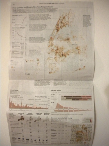
Today the New York Times published an in-depth examination of NYPD stops of individuals ‘based on a reasonable suspicion of a crime’. The item includes a lengthy article; a printed, full-page information graphic; and an online, interactive piece from which the printed piece appears to be derived. The print piece is credited to Ford Fessenden and Janet Roberts, the online piece to the same along with Matthew Bloch.

Print Version

Print Version
Print Version

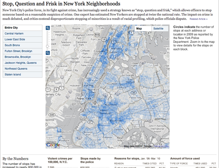
Online Version

Screenshot of the Online Version

Each version of the information graphic centres upon a street map of the five boroughs. Data for the number of stops is graphed at the appropriate addresses, thus making a geographically-correct map appropriate for the type of data. What is interesting is that a decision was made to represent the number of stops by means of the area of circles presumably centred upon the address or the street—each police stop is encoded into the circle by an incremental edit to the circle’s radius. This is despite the fact that area is less than an ideal means of discerning comparisons between discrete datapoints. I am left to wonder if other means of representing the data could have been perhaps more effective. Perhaps if individual streets were coloured according to a carefully crafted distribution one could see a better examination of individual streets. For while absolute fidelity would be lost in grouping datapoints into bins, individual streets and intersections would become far more visible and, perhaps, accessible. Perhaps there are even other ways of representing the data that are not so readily apparent to me.

And while on the topic of street-specific data, an interesting point about these pieces is that the online piece displays the circles atop a desaturated Google map of the region whereas the print piece is atop a stripped-down outline of the five boroughs. Some of this may well be due to the difference between the screen and print resolutions. However, I find that the Google map is distracting for displaying too much in a nearly garish fashion. To the designers’ credit, they reduced much of those distracting elements by eliminating colour from the equation. However, and perhaps this is an issue of personal aesthetics, the map is still competing too much with the circles. Despite the reduction in quality on the newsprint, I prefer the print version of the map.

That all, of course, assumes that one is looking at the full picture of the city. The online version allows one to zoom into particular neighbourhoods and intersections. To some degree this alleviates the clutter of Google’s maps but for the loss of realising the larger message. From my perspective, the printed piece provides a more interesting view of the whole story, for the large map is clearer through the reduction of extraneous map data but the interesting neighbourhood stories are highlighted on the large map with the most interesting given a detailed review. And it is in this review that the specific features of street names, buildings, &c. are made available to the audience. Indeed, the detailed look at Brownsville, Brooklyn is not available in the same level of clear, concise depth as it is in the online version.

Another advantage of the print format is the ability to present the map in a larger context and integrate stories and supplemental charts in the white space carved out by the natural geography of the boroughs. Combined, these elements occupy all the space above the fold whereas in the browser windows I used at both work and at home, only the map and one story for the selected neighbourhood is immediately visible. Thus the print’s integration, albeit made at the expense of the online’s interactive map, makes for a more inviting initial experience.

The remainder of the print and online versions are largely the same with the exception of the detail about Brownsville—which, as aforenoted, is available as a subset of of the online map and is provided outright in the print version. The space of the print version allows for the charting elements to be laid out amongst two columns whereas the online version is a single, vertical column down the webpage. Between the two versions, the largest difference is colour. I would suspect this is due to the differences in fidelity between printing the charts and viewing the charts online. I think both colours work in their respective medium.

Of the remaining graphics, the most interesting is that which displays the breakdown of stops by age in comparison to the city’s population as broken down by age. The first interesting point is the omission of a vertical scale; I can only assume that the scales are identical in both positive and negative directions. I did, however, readily understand the chart. Some may not ‘get it’ as quickly as one is asked to add the city population as it heads in a typically ‘negative’ direction. However, that the entire piece is designed to invite one to explore the statistics in detail, I think creating charts that may require some to think just a few seconds more are perfectly acceptable.

When the information graphic is combined with the whole of the article, the New York Times has again pulled off an impressive feat of editorial design that combines adeptness at the use of the English language with video and photography—from the associated multimedia from the article—along with the here-critiqued information design. Such level of depth provides a well-rounded examination of the issue or subject at hand and better informs the audience by way of both anecdote and fact while photography brings the audience visually into the story.

How an Airborne Division is Organised

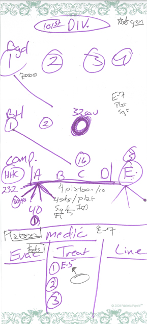
I took a trip down to Clarksville, Tennessee this past weekend and spent some time with a member of the 101st Airborne. At some point, I admitted that I had no idea how the army was organised and so this member proceeded to do his best and explain to me how the army division is broken down. It was done visually by means of a chart, which I appreciate as a designer. Perhaps if I have some time, I shall attempt to translate his drawing into something more designed—fully admitting that such an outcome was not the intent of this drawing.

101-div-web

The purple is his explanation of a division into brigades, battalions, companies, platoons, squads, and fireteams. Beneath is the explanation of a medical platoon, with three different teams. One team is in charge of injuries on the line, or line medics. In a movie, when people scream medic after being wounded, these are the medics for which they are calling. Evac medics get the wounded from the line to a hospital-like place where they have the third group of medics, treatment medics. An E-5, or Enlisted rank of 5 (they go 1–10), is in charge of two other people or sub-groups. I forget which. But the E-5 is the most senior non-commissioned officer in the group. He has an E-7 non-commissioned officer in charge of him at the level of the platoon headquarters. I think.

The complicated lines in the middle explain how the rifle or infantry companies are organised. Two fireteams of five soldiers constitute a squad. Four squads constitute a platoon for about 40 people. And four platoons make up a rifle company for about 160 soldiers or so. The rifle battalions have a headquarters company with the scouts, medics, and mortar people. Then they have four rifle companies, Alpha, Bravo, Charlie, and Delta. Echo is a supply and maintenance company that makes sure the other companies can operate and fight. And if I recall correctly Delta Company is the heavy weapons company where they have, well, heavy weapons I guess.

At the battalion level are two infantry regiments, the 32nd cavalry regiment with all the tanks, and then if I recall there are several other support-like units at this level. But I think to save my comprehension, these were omitted from the diagram. The line connecting the 1st Battalion to the company diagram indicates that this is how each rifle or infantry battalion is generally organised.

Above the battalions are the brigades.  If I recall the explanation correctly, there are the four infantry brigades, each organised like below, and then not shown are support units and the aviation brigades, which have the helicopters and aircraft. This is because the 101st specialises in deploying its infantry via rotary aircraft, which I think means helicopters. I do not believe that they jump out of airplanes.

The back of the paper explains the ranks of officers. An interesting quirk is that a major is superior to a lieutenant but that a lieutenant general is superior to a major general. The 101st is headed by a two-star general, which is, I think, a major general.

And now I know. Or at least I think I know. And knowing—or at least thinking you know—is half the battle.

Visualising the Olympics

This weekend was pretty busy. We had another earthquake in Latin America—if one includes Haiti as part of Latin America—and the closing of the Olympics. Both have prompted some information graphics that are worth noting and comparing. I am going to leave the New York Times’ explanation of the Chilean earthquake to another post and instead focus here on the Olympics.

I wanted to look at three different visualisations of the Olympics, chiefly centred on the always popular medal count.

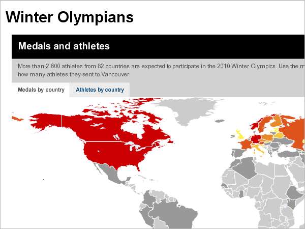
First we have CNN, which dedicates an entire special coverage site to the Winter Olympics. The site has the 2.0-esque feel with different boxes providing the user with different types of material: text-based stories, video, access to an interactive map, and a medal count. The map is what first strikes me because of its warning of reds and oranges and yellows. When I clicked to access the map, however, I felt disappointed in what appeared. And then I wonder why I am being warned about the US and Canada.
medal-map

Generally speaking, a lot of the world’s landmass did not participate. And of those that did, not a lot won any medals. The vast emptiness of the grey map does a disservice to those much smaller areas of the world, particularly in northern and eastern Europe, that did win but are difficult to see. And, personally speaking, as a fan of Antarctica, I was disappointed to see they neither contributed athletes nor won any medals.

What does work, however, is the idea of highlighting those nations that competed. Perhaps not everybody knows that not every nation competes. The map could have been better executed or even a more stylised visualisation of percentages of regions that competed. 7 nations on the African continent, by my quick count, did compete, while three or four European countries did not. The point is important to make. The visualisation, however, does not support it as well it could.

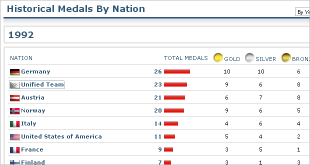
The medal count is also quite interesting from CNN. The special coverage site maintains a snapshot of the leader board that links to the Sports Illustrated medal count. From Sports Illustrated, we are provided a simple table-driven display of who won what with little bar charts to highlight the total medal count. By clicking on a country you see the historical details of the country’s performance, again presented as a table with a bar chart for the total medals won in each year. What I find lacking, however is ranking the countries only by total medals. If someone is more interested in the best gold-medal-winning countries, one has to work to find the data.  A simple ability to sort by medal type would be a valuable addition.
medal-count-92

An interesting situation arises, however, when looking at the historical figures. I am no expert on the Olympics. I did not watch any of them this year. Nor have I really watched them in the past. However, I do know that sports are added and subtracted. So, by clicking on Germany, for example, we see six medals won in 1936 versus the 36 in 2002. In 1936, however, I count only 51 medals total. In 2002, I count 234 medals. 12% compared to 15%. It does not seem so drastic an increase when put into context.

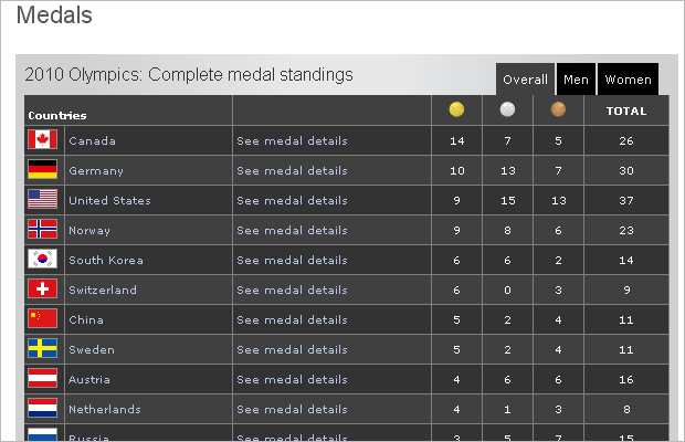
The BBC also has its own special coverage of the Olympics and has its own charts and tables to support the medal count. The main table they chose to use is interesting to me because it is particularly dark compared to the white and grey aesthetic of CNN and the New York Times (below). It certainly stands out. However, when I say ‘it’ I am referring not to the medal count but to the horizontal bands of dark greys and blacks. Between the dark colours, the small type for the medals, and the large flags to identify the countries, I find the medal count last. And when I find it difficult to sort by anything other than the default. But the default is not the total medal count as with CNN. Instead, it is the gold medal count. An interesting choice.
medal-count

The chart the BBC provides for total medal winnings is also interesting. You can compare across countries, years, and medals. Some of the interface makes it a bit tricky. For several minutes I was trying to figure out which years were which at the outset only to finally realise that I was looking at all years. Perhaps if even all the years were a light weight and then the year selected made bold it would be easier. Or a more noticeable shift in colour.

And then I started trying to discern between countries and was left with three-letter abbreviations for each country. And I could not. Perhaps my inability to figure out which country was which stems from my being an American. But I do like to think that I am pretty good at identifying countries. I thought if I moused over one of the stacked bars the abbreviation would reveal its true meaning to me. But it did not. And so I am left looking at stacks of medals for countries I cannot identify.

The stacked bars are interesting for they are not ideal in comparing medal counts within each country—but the mouseover state provides the required detail. Switching to the country comparison makes it a tad easier, but one must still filter medal by medal. Then aesthetically I do not care for the polished, faux-three-dimensional appearance. Nor do I think most of the bars need to be as wide as they are.

Overall, I like where the BBC was trying to go with lots of cross-comparing and filtering to break down medal counts and historical performance. However, aesthetically, I find too many elements large, bulky and distracting. From large flags and small type to black–grey bands and thick stacked bars, the interface is a tad too cluttered to really allow what the BBC did to show.
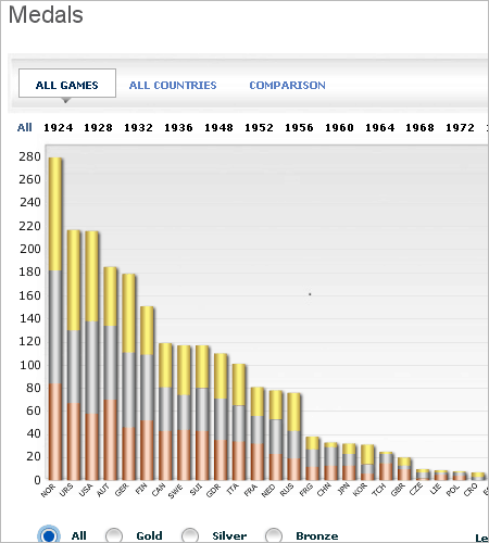
medal-comparison

Lastly, I want to look at the New York Times. Like CNN, the Times has created a map of the medal-winning countries in the Olympics, both current and historical. Unlike CNN’s map, however, the map by the Times is not based strictly on geography and each country is represented by a ‘bubble’ whose size corresponds to the number of medals won. I am not particularly keen on bubbles for displaying values. However, by eliminating those parts of the world not participating, the user can instead focus on the results. And those results, while not on a map, are spatially arranged to indicate their regional groupings. For example, the European countries are grouped together and coloured differently from those in North America. Switching tabs quickly reorganises the bubbles into rows ordered by numbers of medals won irrespective of geography.These are interesting design decisions and while I have reservations about using bubbles, the exact figures are provided as one moves his or her mouse over the bubble.
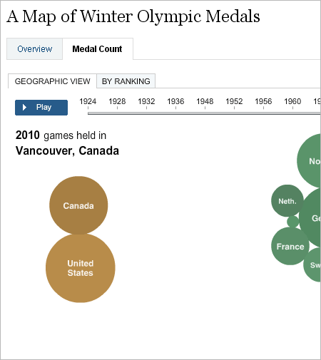
medal-map

For the medal count, we see another table. The numbers are cleanly presented with small flags to the left—and without the bars of Sports Illustrated. Like both CNN and the BBC, one can dive deeper into a nation’s particular results by clicking on that nation. Yet, the experience of clicking into a nation is much smoother with the Times than with the others. No additional pages load and I am not watching my screen jump about to and fro. Instead, the additional information loads in a panel to the right of my click. It is a quick and clean transition that does not leave my frustrated by jumping browser windows.
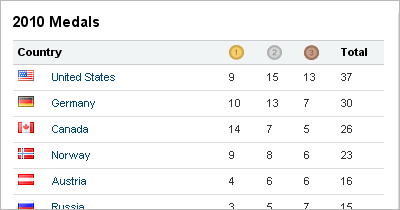
medal-list

Yet, the additional information loaded is quite text heavy. And with the exception of the headers for each sport, nothing in particular stands out. Not the sport, not the medal won, not the athlete who won the medal. While the quiet type is aesthetically pleasing, it lacks punch. Instead of reading the words gold, silver or bronze—since we are looking at the medals—perhaps just their icons could be used. Perhaps the athlete is in bold. I would just like something to which my eyes can be drawn in the table.
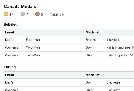
canada-detail

The New York Times effort is brilliant work. Clean and simple design brings out the information—even if such information is presented in the forms of bubbles and such. Tables are rather clean and easy to read. I think their effort a success. Not perfect, as I find the more detailed table insufficient in terms of visual distinction, but still a success.

All of the efforts are significant and worthy of mention. Each has some flaws and each has some strengths. And admittedly, each is more complex and detailed than I have described and commented upon here. But I have to stop somewhere.

The Challenge from FlowingData

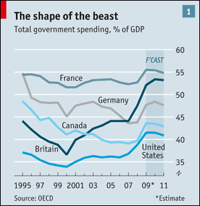
The 25 February posting from FlowingData issues a challenge to improve a chart from the Economist. I find that the Economist usually does pretty solid work and so improving their output is by no means easy. Regardless, I figured I would further delay starting my Friday work by spending 15–20 minutes on an attempt to improve the Economist’s work.

Original from the Economist vs. My Attempt

challenge-original

challenge-redux

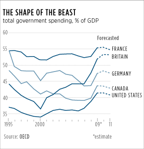
I did not find a whole lot of flaws in their chart. Most unnecessary bits have been eliminated and we have a clean line chart. The semi-advantage allowed us all is that we do not have to follow the branding guidelines of the Economist. Initially, I attempted to do a straight grey-scale chart but found the overlapping lines could be a bit confusing. And so I added a hint of blue and then tinted lines when they overlapped to aid the reader in following each line.

I also eliminated the shaded Forecast area and replaced it with switching the solid lines of the historic data to a dashed line for forecast data. The exact shape of the lines may not be exact because I traced over the lines with the pen tool in Illustrator—but for these purposes that seemed reasonable to me.

The other ‘big’ change was more typographic in nature. I decided to highlight the countries and drop back the labels by making the latter grey.

Looking at the Haitian Earthquake

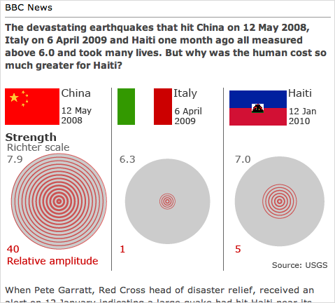
The BBC has posted an article addressing the causes for the horrible death toll in the Haitian earthquake last month. Charts and data-driven graphics supplement the text and provide a parallel, though not synchronous, visual story.

screenshot of BBC article

I applaud an intensive use of graphics, especially data-driven graphics, to better relate a story. Perhaps especially because not everybody can learn something simply by reading it. Many among us are instead visual learners, and by incorporating graphics into stories, be them online news articles, printed magazine articles, or interactive experiences, we can reach a larger audience and hopefully inform, impact, and influence said audience.

The graphics for the BBC article do some things well and some things not so well. Firstly, as a series, the graphics are varied well enough to not be overly repetitive. We have two sets of bar charts, three sets of area-of-circle charts (I presume), and what Nathan Yau at FlowingData called the everything chart. And if we look at the placement of the charts within the article (B for bar, A for area, and E for everything) we see A–B–E–A–B–A. The placement of the graphic types within the structure for the visual component of the article is sufficiently varied not to bore the audience.

Secondly, the graphics are well done through the restrained use of colour. Each graphic is composed of tints of grey and red. Grey is largely used as the base colour for the graphic while red or its tints accent the key elements of the visual argument. For example, when comparing the number of people dead among the affected people, a single square is coloured red. In the larger areas of grey for China and Italy, that single square or single person, while not lost, is not necessarily readily important. Instead, it serves as a link across the countries for when people look at Haiti and that red square stands out among fourteen other grey squares.

On a few other fronts, however, the graphics stumble where, if a bit more attention had been paid, they could have really strode to the front of the pack.

From the perspective of representing data, I have three qualms with the graphics. The first is somewhat minor—for it may have well been intentional. Although one of the underlying points of the article is the sheer difference in scale of the impact, the Italian earthquake is often difficult to visually compare in detail next to the Chinese and Haitian earthquakes. Why? Because the Italian numbers are visually insignificant. Could this have been resolved in a different fashion? Yes. However, as aforementioned that could have been an intentional design decision and I only point it out as something worth considering.

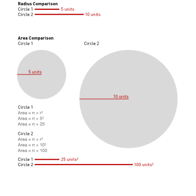
Secondly, and more importantly, I have concerns about the area-of-the-circle charts. Chief among those concerns is that nowhere is it specified that we are looking at area instead of, as is sometimes the case, the radius of the circle. This error is significant and I shall illustrate below. If we take, for the sake of example, a circle of radius 5 units and compare it to a circle of radius 10 units, we have a difference of 5 radius units. Circle 2 is, by one measure, twice the size of Circle 1.

And while some compare radii of circles, others instead compare areas of circle—as I assume but cannot be certain of in this instance. However, if we look at 5 units and 10 units as the radius for the areas of Circles 1 and 2, we arrive at a difference of four times the size.

diagrammatic explanation of radius vs. area

This is not a problem specific to this article—although it could have been partially solved by stating area comparison or providing a scale. Unfortunately, this problem appears with an unsettling degree of frequency. But the problem is also compounded because people are not the best judges of area. It is far easier for an individual to compare two bars and see one as twice the size than it is to compare the area of two circle and see the same difference.

The problem of comparing length to length times width for a datapoint has the fair counterpart of visual repetition aforementioned. One of the three circle charts could easily be replaced by a bar chart. The two others could also be replaced, albeit with a little more work. However, the article would then be visually boring for it would be replete with bar charts.

And so the problem of comparing areas is one to be handled carefully. This piece has some potentially serious problems in comparing data. However, the quick and easy fixes would make the piece less visually interesting and thus, perhaps, cause the reader to lose interest. And with interest lost, the reader clicks away and the article fails to make an impact. On a case-by-case basis, the designer must often make the decision between fidelity to data versus capturing the reader’s attention. And here, I think the pendulum swung just a bit too far to capture the reader’s attention.

My third major point of contention, however, concerns the data itself and an incongruity in the graphics. Understandably, the earthquake in Haiti is a recent event. And indeed, the rebuilding and thus the cost is a current and ongoing event. Therefore, nobody should expect any institution to have anything but cost estimates. The final graphic makes note of the fact that we have no hard figures and that all figures are estimates.

Yet, the graphic provides two visual estimates hinting at two substantially different figures. The straight cost is represented on a bar chart that states “estimated at several billion” but visually depicts $40 billion. The cost as relative to GDP includes an asterisk for a footnote that shows the cost as but $2 billion.

Using the estimates for an early comparison of the financial cost of the earthquake is perfectly valid so long as the numbers are noted as estimates—as they are here. However, one should use the same estimate consistently across the piece. Because here, the use of different estimates can be used to imply that the straight cost is nearly 15 times more than that of Italy’s cost. But when using the cost to compare the cost relative to the economy, Haiti’s straight cost is $500 million less than that of Italy’s cost. If anything, either the bar chart should have had no bar for Haiti, or made use of the dashed red line at the $2 billion line.

And so while I certainly have reservations about the graphics as a whole, I support the decision to use data-driven graphics to support the story and the argument.