All the Eggs

We made it to Friday, everyone. Huzzah.

This is based off absolutely one of my favourite infographics out there—Charles Joseph Minard’s map of Napoleon’s invasion of Russia. For those unfamiliar with it, he tracks the size of the French army as it invades Russia and gets thinned out along the way. Yes, some are to battles. But, the bottom of the plot also tracks temperature. The temperature of winter in Russia. And you can see how that too impacted French troop numbers.

So this modern work needed to get a shoutout here, even if it doesn’t have the temperature on Hoth. Or in the vacuum of space. I hesitated to post it for a few weeks because of the film and not wanting to post spoilers. But upon further reflection, we basically all know how Rogue One has to end—the plans get stolen and the Death Star eventually gets blown up. So I see no harm posting this now.
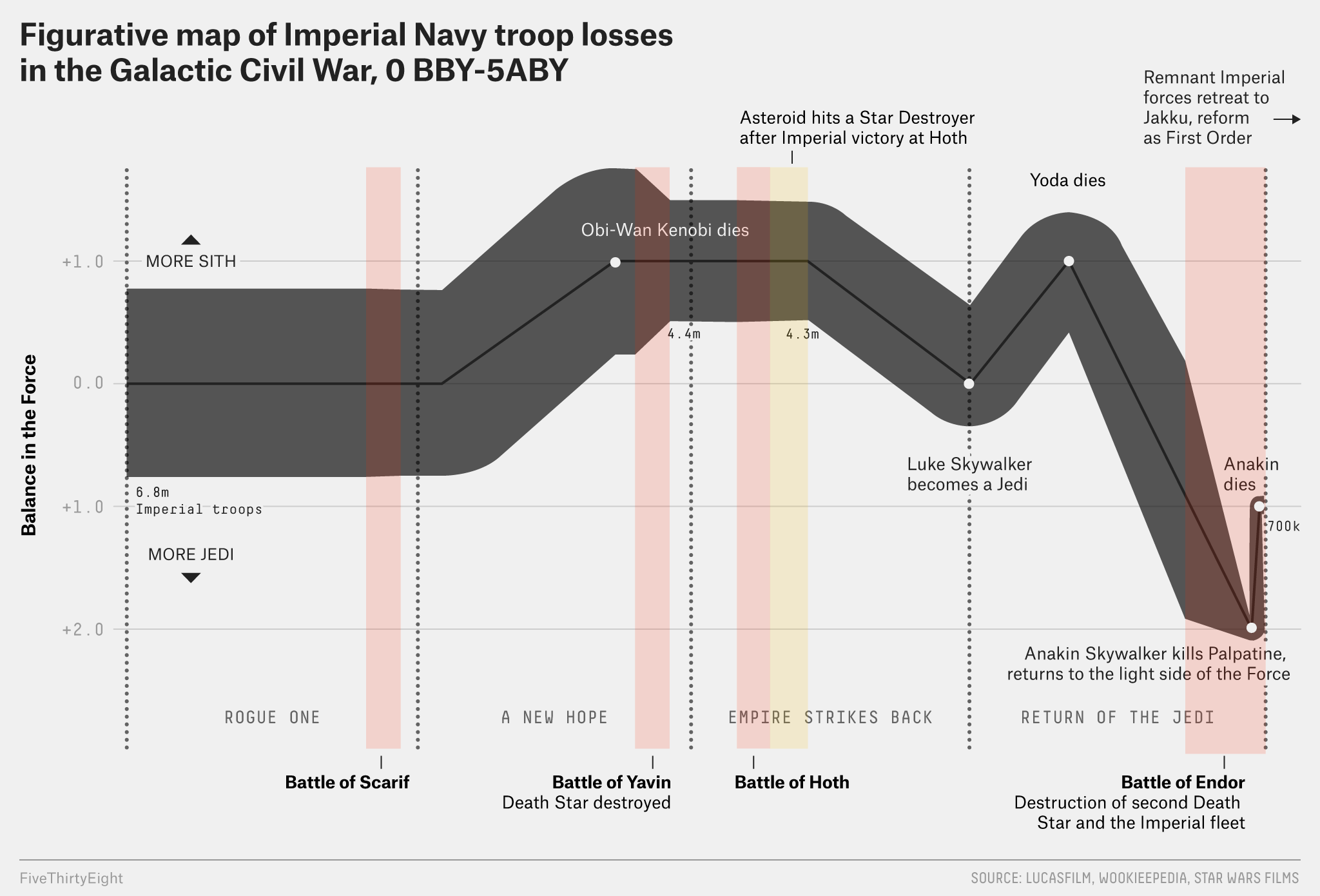
I wonder if it's just basically don't invade colder countries in winter.
I wonder if it’s just basically don’t invade colder countries in winter.

Credit for the piece goes to Walt Hickey.

Capturing a US Navy Drone Submersible

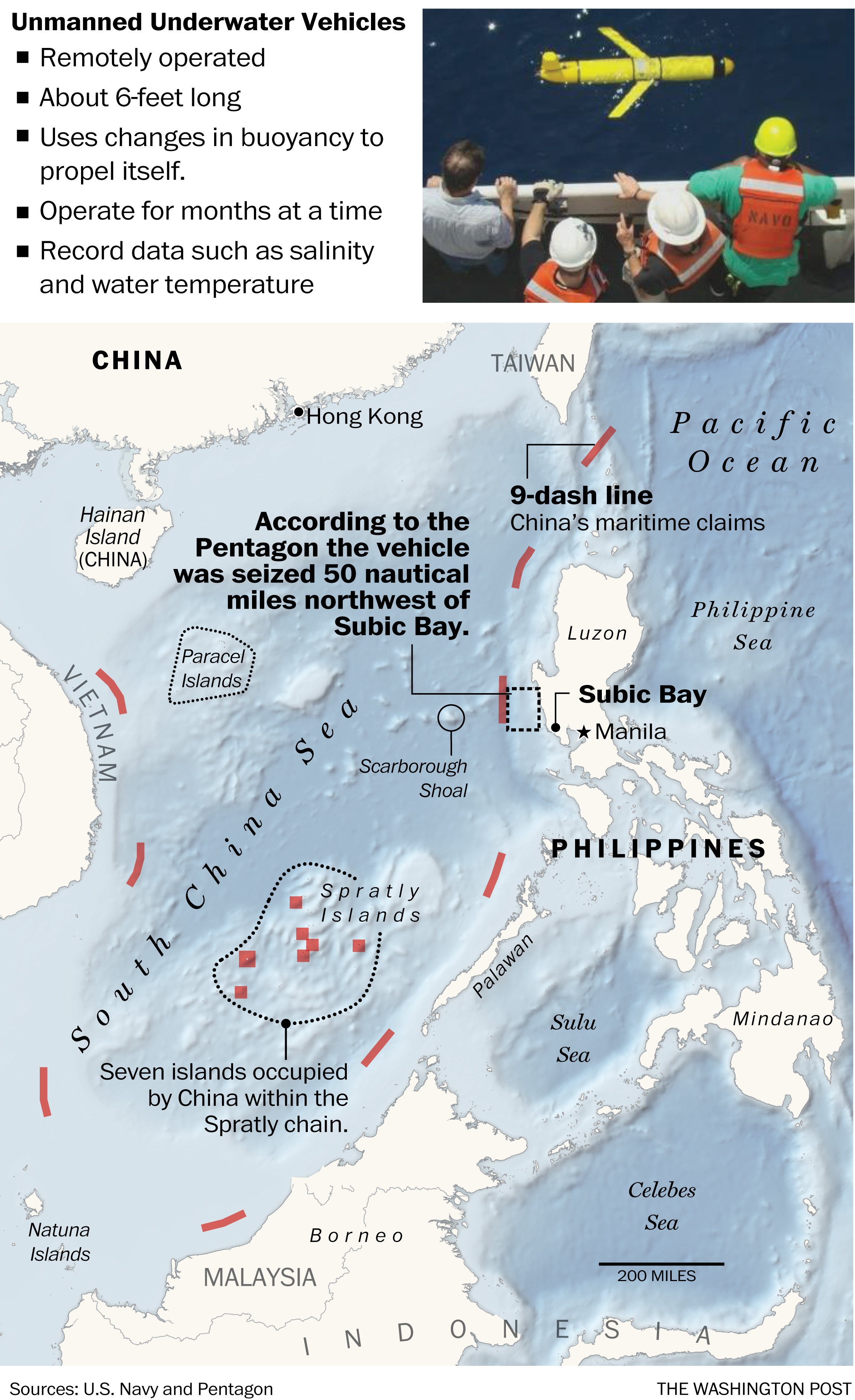
Last Friday China seized a US Navy submersible drone—like the drones the Air Force uses but for underwater purposes—in international waters off the coast of the Philippines. This graphic from the Washington Post shows how, while in international waters, the seizure occurred not far outside China’s Nine-dash Line, which they claim as territorial waters.

Where we lost our drone (to China)

Credit for the piece goes to the Washington Post graphics department.

The Asian Arms Race

In case you missed it, two weeks ago President Duterte of the Philippines had some interesting things to say regarding the relationship between the Philippines and the United States. “America has lost” and “separation from the U.S.” were among the two big lines he spoke to a Chinese audience. But the Philippines are an important part of President Obama’s pivot to Asia strategy as we have been spending money and time improving defence ties. Naturally issues like the the pivot underpin Trump’s claims about poor judgment when it comes to the Obama/Clinton foreign policy.

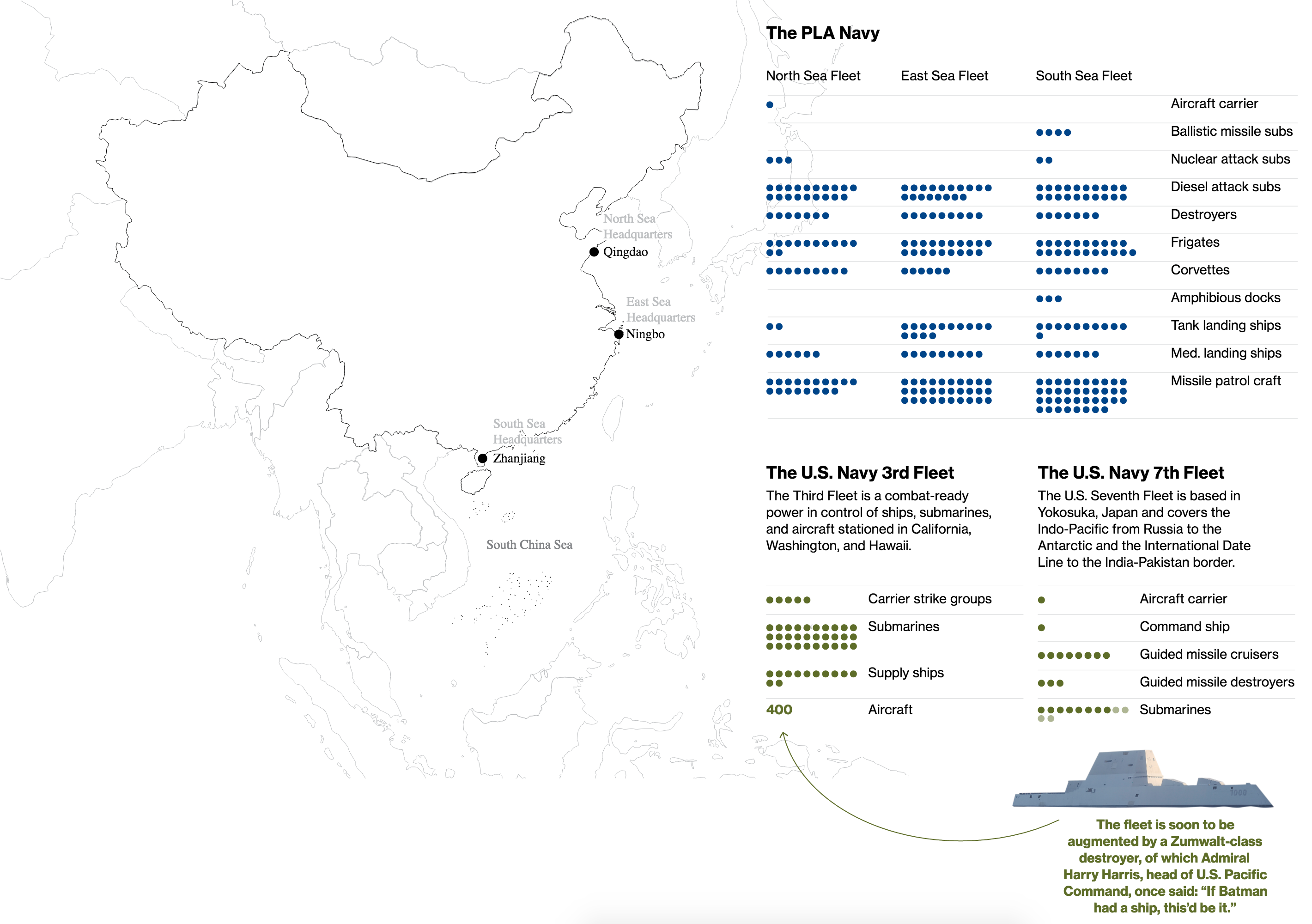
The pivot’s improving defence ties come at a time of region-wide increases in defence spending. Thankfully Bloomberg put together an article with some nice graphics earlier this year. As someone who has always had an interest in naval things if not military things, see my numerous posts on that here, I thoroughly enjoyed reading the article and digesting the graphics. The one below compares the strengths of the Chinese fleets to those American fleets permanently assigned to the Pacific Ocean region.

The Chinese Navy vs (part of) the US Navy

Of course the question becomes, beyond making our military stronger, just what would Trump do to counter or affect the arms race in the Asia Pacific region?

Credit for the piece goes to the Bloomberg graphics department.

Moving on Mosul

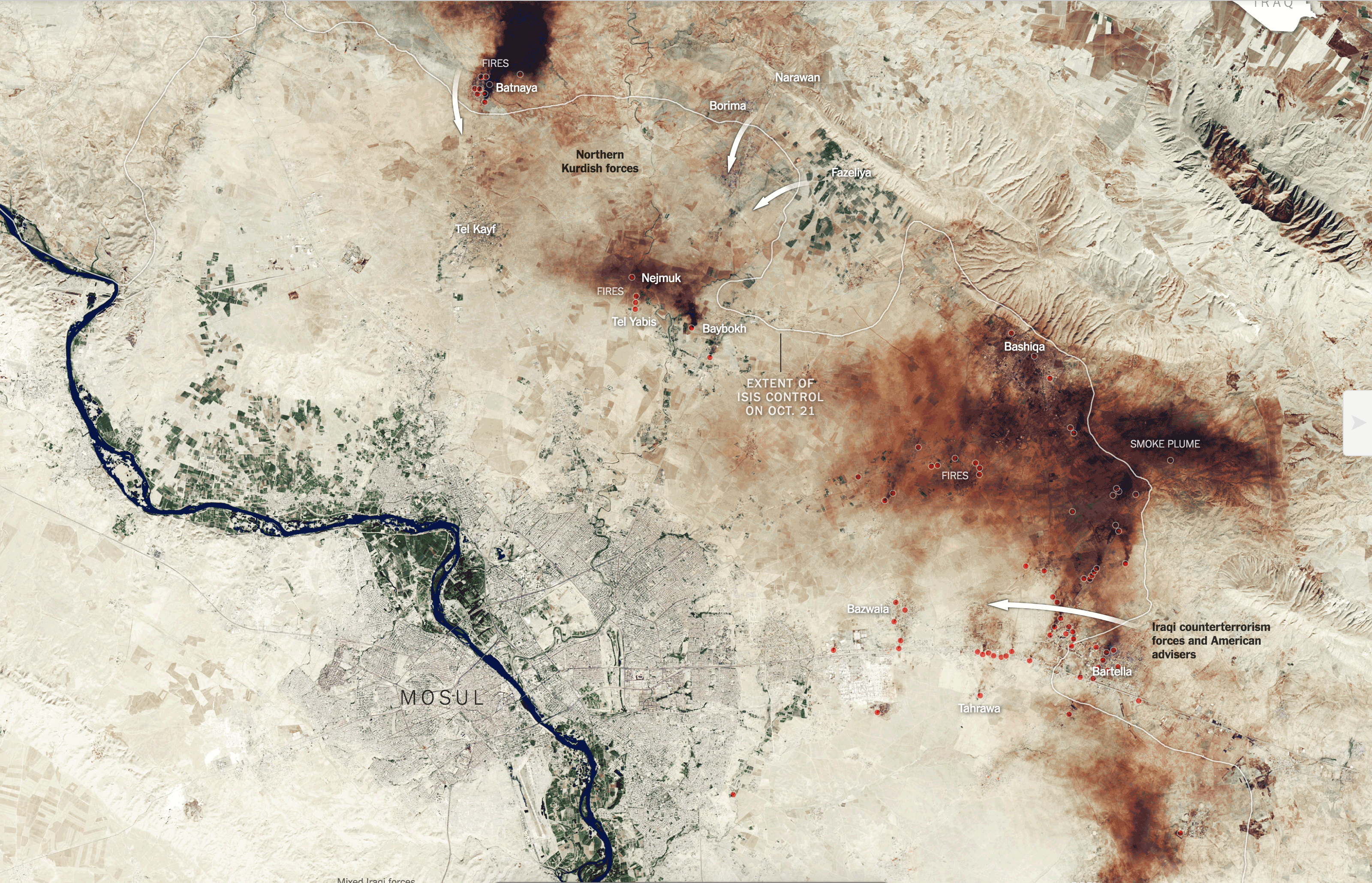
If you didn’t already know, the Iraqi Army and Kurdish forces are moving on Mosul, a city in northern Iraq overrun by ISIS back in 2014. The New York Times has illustrated a satellite image of the Mosul area to show how the forces are progressing in their assault on the city.

All the smoke
All the smoke

Credit for the piece goes to the New York Times graphics department.

Airplanes in Hangars

Today’s post features a simple set of graphics on the BBC, however the creators were actually the Asia Maritime Transparency Initiative. The background? The increasingly tense geopolitical situation in the South China Sea, where China claims numerous islands and reefs claimed by other countries—and to a smaller extent other countries make similar such claims. Just a few weeks back, the Hague ruled against Chinese claims against islands within the Philippines territorial waters. But as these graphics show, it takes more than a legal decision to effect change on the ground.

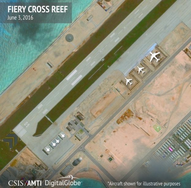
Satellite photography shows military installations on numerous Chinese-held islands. But what makes the images potent in the communicative sense is the simple overlay of white plane illustrations. They show how many fighter jets, support aircraft, patrol aircraft, &c. that China can base at the various military installations. It is a simple but incredibly effective touch.

Fiery Cross Reef
Fiery Cross Reef

Credit for the piece goes to the Asia Maritime Transparency Initiative.

The T-14 Armata

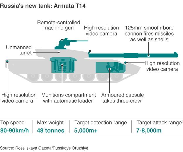
Or the post’s sub-title could be something like, Boys with Toys, because I have long enjoyed diagrams of military hardware, like these examples. Today’s post is about Russia’s new main battle tank, the first new design since the 1970s: the T-14 Armata. It premiered in last year’s parade and is expected to enter service soon. This BBC article from last year’s parade shows the various new models expected to enter the Russian Army.

Russia's new toy
Russia’s new toy

Credit for the piece goes to the BBC graphics department.

China’s New Islands

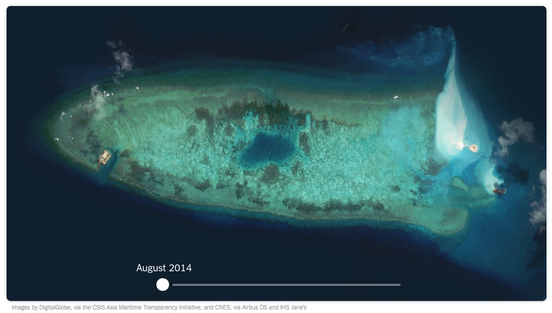
Okay, so the title might be a bit hyperbolic, but the point that China has spent the last few years expanding minor reefs into major military installations still stands. This New York Times piece is a few months old at this point, but through a combination of maps, photography, and diagrams, it illustrates what has been going on in the South China Sea.

Fiery Cross Reef
Fiery Cross Reef

The screenshot above is of the first still in a short time lapse video introducing the article If you do not have the time to read the entirety of the piece, just watch the video. A lot can happen in one year.

Credit for the piece goes to Derek Watkins.

Types of Nuclear Weapons

When I was in high school I began to listen to music. To find music. To find artists. A guy who owned and operated the store next to where I worked recommended David Bowie, that guy whose songs I had heard on Philly’s classic rock radio stations. Back in those days we still had record stores—not that I knew what a record was—and I found a few used CDs—now that kids today would know what a CD is. Over that summer, I picked up a lot of new music. But what struck me about this David Bowie guy is that Space Oddity, Tonight, and Heathen all sounded so different from each other. He was a great one. And while I’m certain there will be some graphic in the future about his timeline—how can there not—today I am going to follow up once more on the North Korean nuclear test after coming across this graphic from Reuters.

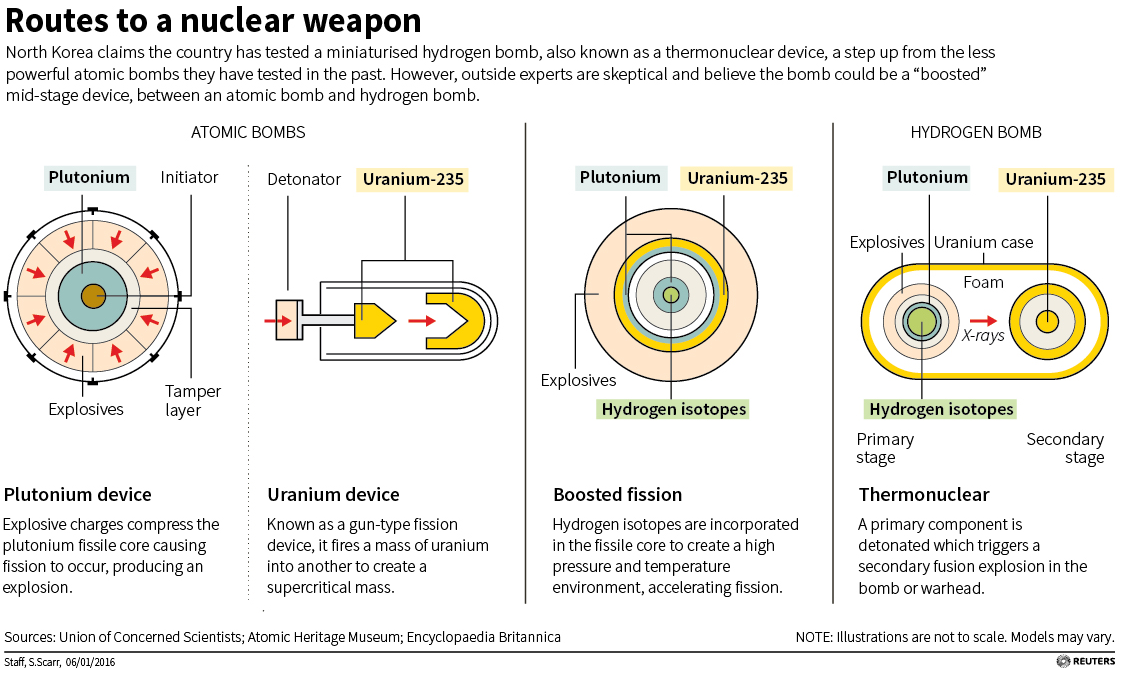
You will recall how last week I looked at a New York Times post that explained the differences between a few different types of nuclear weapons. Well, here Reuters illustrates those differences.

Types of nuclear weapons

Credit for the piece goes to S. Scarr.

Sailing Through Southeast Asian Waters

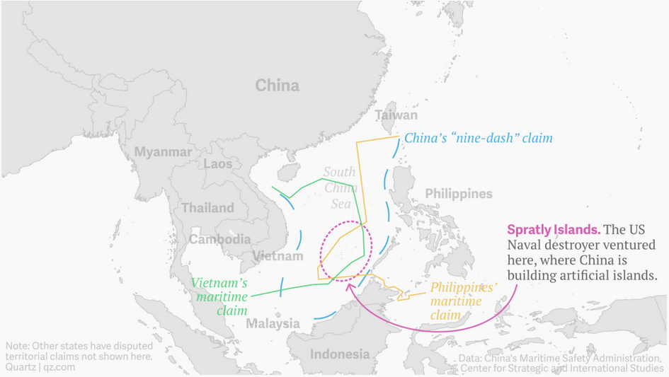
Today the US sent a guided missile destroyer through what China claims—but few recognise as—its sovereign territory, twelve nautical miles off the coast of semi-artificial islands. This piece from Quartz illustrates just some of the overlapping claims of the Spratley Islands. In the end, nothing happened to the destroyer as China did not counter it with ships or aircraft.

Who owns what now?
Who owns what now?

Credit for the piece goes to the Quartz graphics team.

The Atomic Bombings of Hiroshima and Nagasaki

On 6 August 1945, the United States dropped one of the only two nuclear weapons used in combat on the city of Hiroshima, Japan. 70 years later, the city has been rebuilt and the war is long since done and over—the atomic bombings playing no small part in changing the Japanese calculus of surrender. But, what happened on 6 August and then 9 August (when we used the second of two nuclear weapons on Nagasaki)? The Washington Post has this nice piece with illustrations and maps and diagrams to explain it all.

The damage in Hiroshima

Credit for the piece goes to RIchard Johnson and Bonnie Berkowitz.