Analysing the Urban Environment

Via the Guardian comes an interactive piece from researchers at MIT and the Technical University of Lisbon that allows users to examine urban environments to compare population, energy use, and building material intensity for a select set of 42 different cities. The screenshots below are of neighbourhoods in Philadelphia.
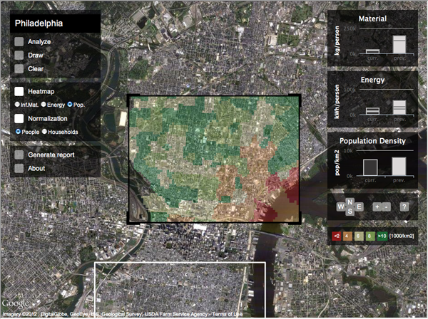
Population density
Population density

Once the user has chosen an area, he or she can move on and analyse a different section of the city. This behaviour generates a comparison on the right of the current area to the previous area.
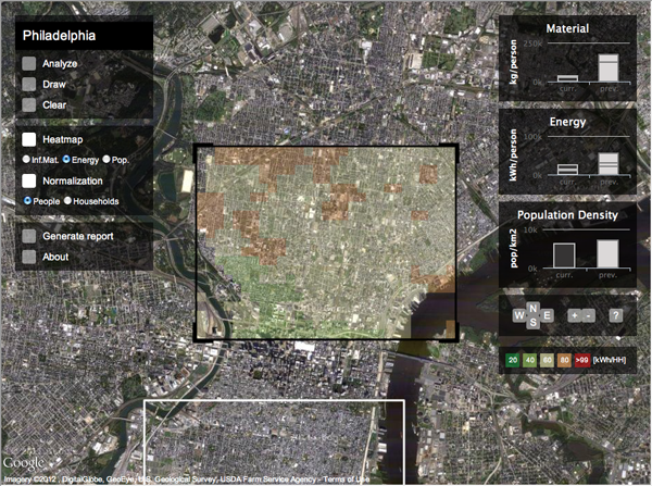
Energy use
Energy use

After the user has found an area of particular interest, he or she can generate a graphical report that summarises the findings for the selected area and compares that to other areas of similar scale in the city.
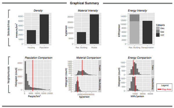
Graphical report
Graphical report

Credit for the piece goes to David Quinn and Daniel Wiesmann.

A Profile of Canada’s Immigrants

On the back burner of infographics to post is this piece from the National Post. The early data indicates that most of Canada’s high population growth rate comes from immigrants to the country. And while those details are not yet available, the piece looks at the 2006 data for an indication of from which places the immigrants are likely to come.

Cropping of immigrant origins

Credit for the piece goes to Richard Johnson.

Today is a Happy Happy Joy Joy Story

For the past two posts I focused on the sinking of the RMS Titanic, an historical event that has always been of some interest to me, but is not always the most uplifting of subjects. When in high-school, I once had an English teacher who took to heart our complaints that our literature selection was rather dark and depressing. So after finishing yet another such story, he had us turn to a specific page in our reader. The title of that day’s story was To the Gas Chambers, Ladies and Gentlemen; it was a story about the Holocaust.

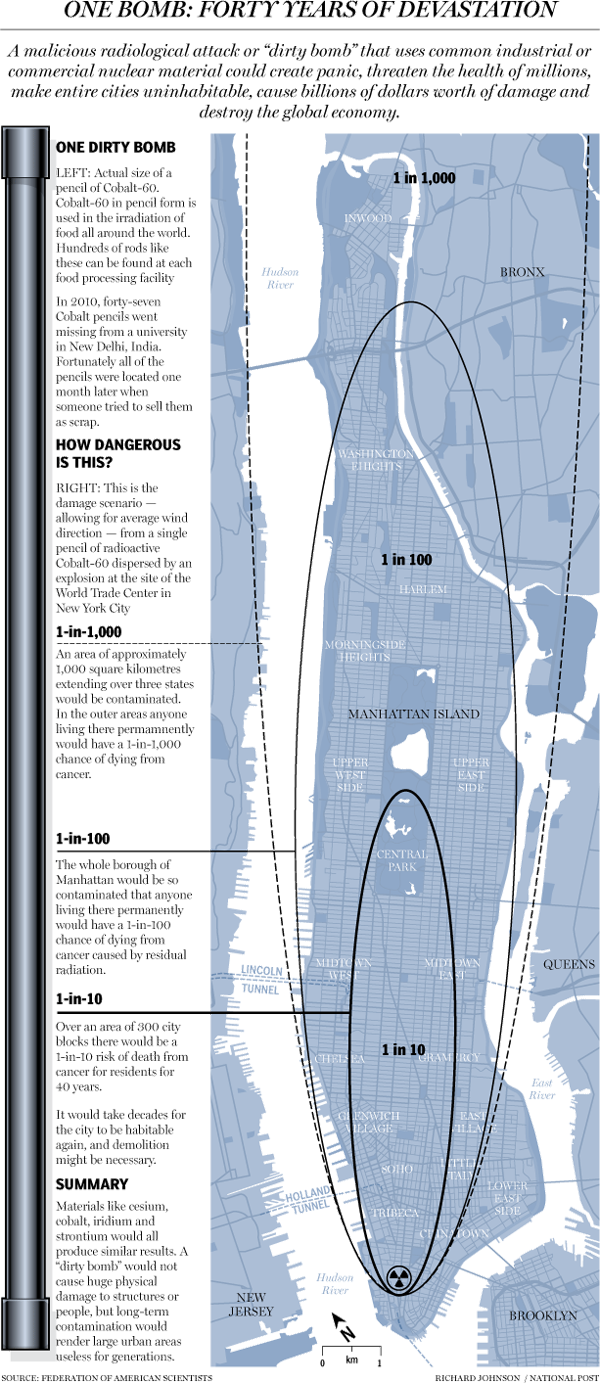
Here is today’s uplifting story. What would happen if a dirty bomb was detonated in lower Manhattan. Courtesy of the National Post.

A dirty bomb in New York

Credit for the piece goes to Richard Johnson.

Rising Seas

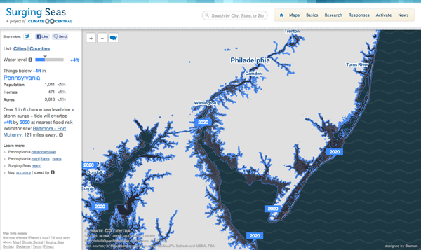
Via the Guardian, Stamen Design has teamed up with Climate Central to create an interactive piece that maps the potential effects of rising sea levels. The user has control over the amount of the rise—this graphic says four feet—after which the coastline recedes to reveal the devastation. This is complemented by statistics of the land, including the population potentially affected along with the number of homes and total acres. In this case you see South Jersey, which is where I spent my summers. As you can see, the coastal beach towns I called home would be underwater. (And the little blue specks inland in Pennsylvania near my hometown, those are quarries; nobody lives there. No need to worry.)

Changing coastline
Changing coastline

The problem, of course, is that a large percent of the Earth’s population lives near the ocean. There are not, after all, many people living in the interiors of the continents. So receding coasts may very well be a problem in the coming years.

The First Rule Is You Don’t Talk About It

There are two things one is not supposed to discuss in mixed company, and let us face it, the internet is some rather mixed company. One of those things, politics, I frequently mention and bring up on this blog. The other, religion, I do not.

Until now. (I think.)

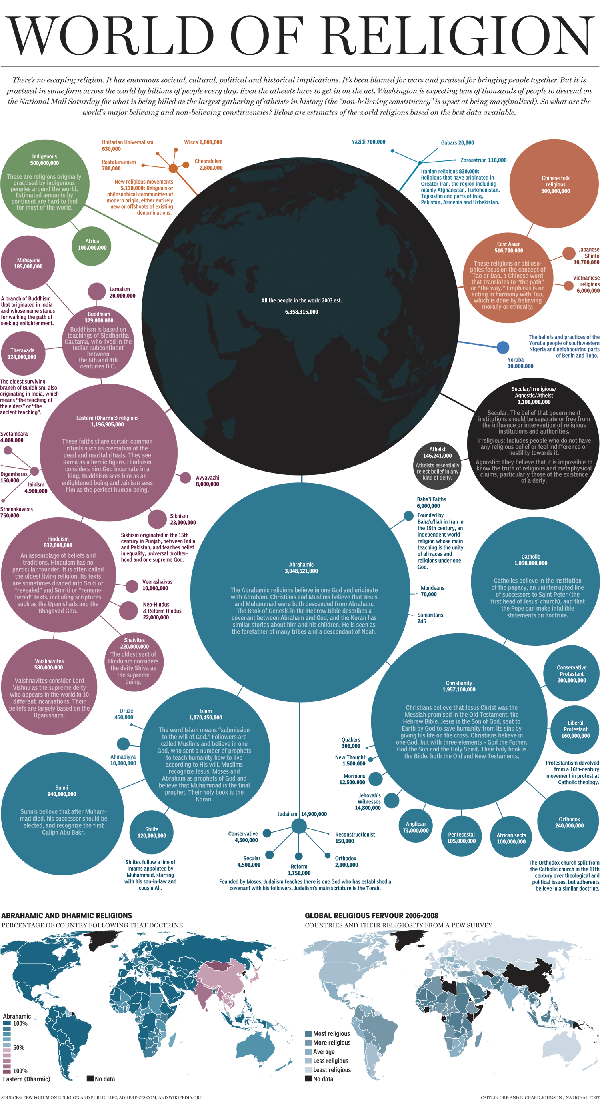
From the National Post comes this work on the size and distribution of the world’s religions.

World religions
World religions

Credit for the work goes to Richard Johnson.

A Timeline of Deaths in Syria

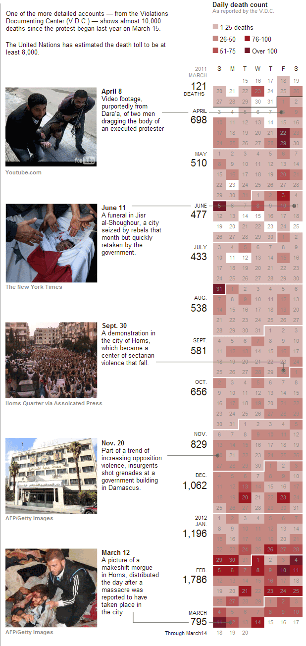
The civil war in Syria rages on. The following graphic from the New York Times accompanies the article and uses a calendar-style timeline to look at the mounting death toll. The visualisation type appears more and more often for time-based data sets shaped around days; we all (usually) understand how calendars work and are shaped.

In this particular case, specific key dates and images are brought out of the timeline and featured on the left. These provide an additional context to the human side of the story  that may otherwise be left in the dates and deaths on the right.

A problem with such a design is the length of the year, which might preclude users of small screens from being able to see the entire year in one screen-height. I am left to wonder about whether the user can make an adjustment to a horizontally-scrolling calendar and if in the future such arrangements may better take advantage of widescreen monitors.

Syrian casualties by date

21st Century Prohibition

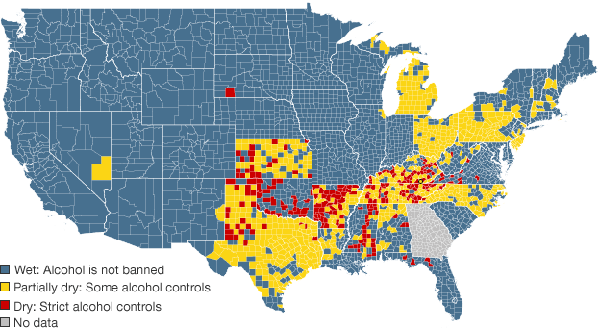
This map comes from the BBC, which investigates prohibition in the 21st century at the local level, as the national policy ended in the early decades of the 20th century.

Dry vs Wet Counties
Dry vs Wet Counties

Credit for the map goes to John Walton, Harjit Kaura, and Nadzeya Batson.

Heritage Maps

From FlowingData comes a post to an interactive piece by Bloomberg that looks at the geographic distribution of different heritage—read heritage, neither race nor ethnicity—groups. (Its choice of groups, however, is slightly contentious as it omits several important ones, including African-Americans.)

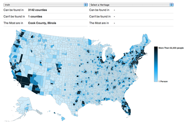
I would say that a typical map like this would simply plot the percent of each county, state, or other sub-division for the selected heritage group. Much like below, as I chose the Irish.

Irish heritage
Irish heritage

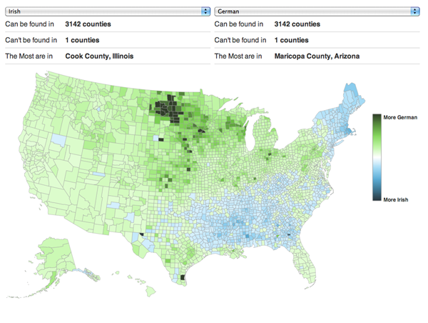
Bloomberg’s piece is a bit more interesting than that because of the ability to compare two groups, to see where they overlap and where they diverge. In doing so, they created a divergent choropleth that can show the subtleties and nuances of settlement patterns.

Irish vs German
Irish vs German

Credit for the piece goes to David Yanofsky.

Bringing 19th Century Mapping Techniques to the 21st Century

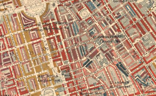
Charles Booth was a 19th century social scientist living in Britain. He famously investigated poverty and mapped out which parts of London were teeming with vicious, lower-class criminals or well-to-do upper class folks. Today, one might use a simple choropleth style to paint whole swathes of London by postal districts or constituencies or some such. But, Booth went street-by-street and house-by-house colouring blocks of London’s residential areas until he arrived at a map far more complex—and thus ultimately more telling—of the intricacies of London’s social structure.

from Booth's original map

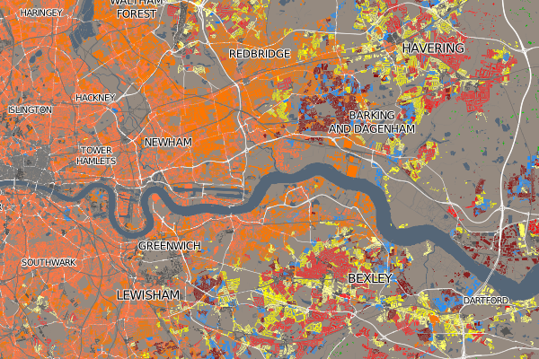
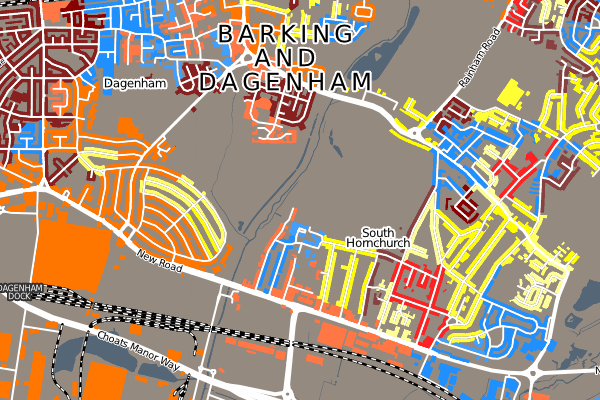
Oliver O’Brien has created a modern take on Booth’s approach to investigate the housing demographics of the UK, which ignores the large areas of the British countryside that are devoid of homes and thus focuses on the denser residential areas of the UK’s major cities.

Eastern London
Eastern London
Barking and Dagenham

Censuses seem to be a natural dataset for such work, but I wonder if in the future we will be able to apply such data visualisations to other geographically-tied data.