Covid Migration

Yep, Covid-19 remains a thing. About a month or so ago, an article in City Lab (now owned by Bloomburg), looked at the data to see if there was any truth in the notion that people are fleeing urban areas. Spoiler: they’re not, except in a few places. The entire article is well worth a read, as it looks at what is actually happening in migration and why some cities like New York and San Francisco are outliers.

But I want to look at some of the graphics going on inside the article, because those are what struck me more than the content itself. Let’s start with this map titled “Change in Moves”, which examines “the percentage drop in moves between March 11 and June 30 compared to last year”.

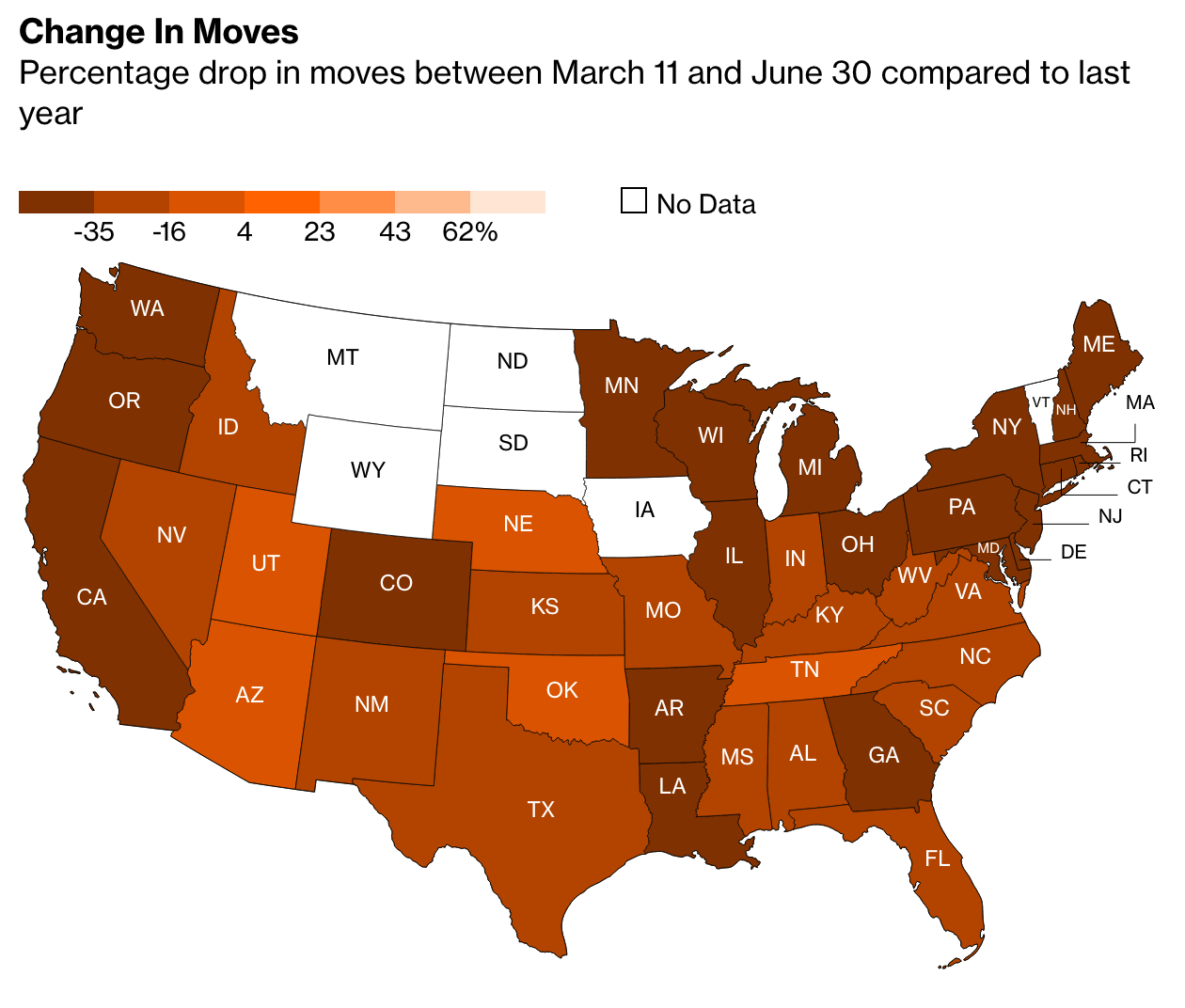
Conventionally, what would we expect from this kind of choropleth map. We have a sequential stepped gradient headed in one direction, from dark to light. Presumably we are looking at one metric, change in movement, in one direction, the drop or negative.

But look at that legend. Note the presence of the positive 4—there is an entire positive range within this stepped gradient. Conventionally we would expect to see some kind of red equals drop, blue equals gain split at the zero point. Others might create a grey bin to cover a negative one to positive one slight-to-no change set of states. Here, though, we don’t have that. Nor do we even get a natural split, instead the dark bin goes to a slightly less dark bin at positive four, so everything less than four through -16 is in the darker bin.

Look at the language, too, because that’s where it becomes potentially more confusing. If the choropleth largely focuses on the “percentage drop” and has negative numbers, a negative of a negative would be…a positive. A -25% drop in Texas could easily be mistaken with its use of double negatives. Compare Texas to Nebraska, which had a 2% drop. Does that mean Nebraska actually declined by 2%, or does it mean it rose by 2%?

A clean up in the data definition to, say, “Percentage change in moves from…” could clear up a lot of this ambiguity. Changing the colour scheme from a single gradient to a divergent one, with a split around zero (perhaps with a bin for little-to-no change), would make it clearer which states were in the positive and which were in the negative.

The article continues with another peculiar choice in its bar charts when it explores the data on specific cities.

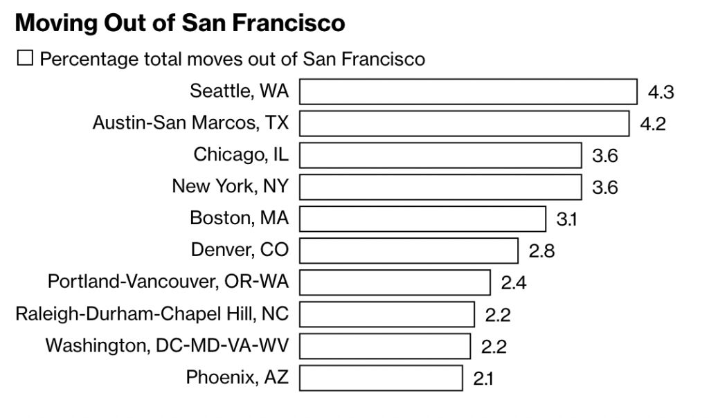
Here we see the destinations of people moving out of San Francisco, using, as a note explains, requests for quotes as a proxy for the numbers of actual moves. What interests me here is the minimalist take on the bar charts. Note the absence of an axis, which leaves the bars almost groundless for comparison, except that the designer attached data labels to the ends of the bars.

Normally data labels are redundant. The point of a visualisation is to visualise the comparison of data sets. If hyper precise differences to the decimal point are required, tables often are a better choice. But here, there are no axis labels to inform the user as to what the length of a bar means.

It’s a peculiar design decision. If we think of labelling as data ink, is this a more efficient use with data labels than just axis labels? I would venture to say no. You would probably have five axis labels (0–4) and then a line to connect them. That’s probably less ink/pixels than the data labels here. I prefer axis lines to help guide the user from labels up (in this case) through the bars. Maybe the axis lines make for more data ink than the labels? It’s hard to say.

Regardless, this is a peculiar decision. Though, I should note it’s eminently more defensible than the choropleth map, which needs a rethink in both design and language.

Credit for the piece goes to Marie Patino.

Where People Really Want To Go

Sorry for the two-week absence, everybody. I travelled to the UK for work and then stayed there and Ireland on holiday. But I have returned, but with the inevitable jet lag waking me up early this morning, I had no reason not to post something.

Late last year, the Washington Post published a small article examining trends in US migration data. The crux of the article? During the recession, people stopped moving from the Northeast and Midwest to the Sunbelt. (I was a rare exception heading from the Northeast to the Midwest.) But, now that the economy is not so sluggish, that movement of people has resumed. Naturally, there are charts to go alongside it.

Migration between regions

I selected the above because while generally fine, I quibble with one design decision. In the locator map in the upper right, take the South, which is coloured dark green for a winner in the game of migration. However, in another map earlier in the piece, Mississippi, Alabama, Louisiana are all losing people. I likely would have left the white states lines off the map. Or reused the same earlier map, but with a thicker stroke to indicate the US Census Bureau regions.

Credit for the piece goes to Darla Cameron.

The EU’s Migrant Problem

Last week we looked at a map produced by the Washington Post, which detailed the routes chosen by migrants and refugees desiring to reach the European Union. This week, I want to compare that to one from the BBC—there are others, even from the BBC, but we will examine them later—that details the differences in countries along the route.

EU border map
EU border map

The previous map simply highlighted countries in the Schengen Area, which allows for Passport-free travel between participating EU members. This map uses colour to denote which countries participate and whether they belong in the EU. But it also uses white lines to indicate border, so that Schengen Area countries seem more contiguous. This allows them to use colour to add the layer of recent news: recently imposed border controls and newly constructed fences. My concern in this particular piece is that those pink and green countries should probably have some sort of line indicating that they do have border controls.

Credit for the piece goes to the BBC graphics department.

Researching the Family History in Ashland, Wisconsin

I’m presently off in the northern reaches of Wisconsin, Ashland in particular, researching part of my family’s history. To aid me in understanding just how this frontier-following family moved over one century, I put together a crude map and a timeline to give me context (and jog my memory) while searching through files in the courthouse.

The movements of the Spellacy family

I am calling the map a migration map. It shows the locations where family members moved to in 1849: Sheboygan (from New Brunswick, Canada). And then how they quickly began to disperse, but slowly head north to Ashland County, before most ultimately headed to the West Coast. (My direct ancestors are that group near the bottom that move back to the in-laws original home of western Massachusetts.)

What I struggle with keeping in mind is that here we are looking at a perfectly rendered and understood map of modern Wisconsin. But in 1849, the state was but one year old and most of the towns to which this family would be going were only a decade or so old and still very much frontier towns without amenities. (Which is why I imagine the women of the family stayed in Milwaukee until the settlements in the north were, well, settled.)

To the right is a timeline. The details are not terribly important and in fact it is poorly designed. But, it was quick to make and will hopefully help me keep the names straight and the places for which I am looking top-of-mind.

Put the two together and you have an example of how I create visualisations for myself just to help me with my own work and research.

Mapping Migrant Deaths

Yesterday we looked at a map of coal plants, with the dots sized by capacity. Today, we have a similar approach in a much smaller graphic about a much different topic. The BBC published this map yesterday in the context of an article about a report of the EU contacting Australia in regards to its migrant interception programme.

Where the migrants have died

Compared to the maps we saw yesterday, I’m not so keen on this. Not the idea, mind you. I think that the story bears telling in a graphical, visual format. Look at how many of those deaths occur in the waters between Libya and Italy. Not between Tunisia and Italy. Not between countries of the eastern Mediterranean and islands like Cyprus or Crete.

But, the blue-green colour used to identify previous incidents is too close to the blue of the Mediterranean for my taste. Though, in fairness, that does make the purplish colour highlighting the most recent incident stand out a bit more. But even the map of the Mediterranean includes details that are not likely necessary. Do we need to show the topography of the surrounding countries? Do we need to see the topography of the sea floor? Probably not, although in a different piece the argument could be made geography determines the migration routes. Compare that to Bloomberg’s piece, where the United States was presented in flat, grey colours that allowed the capacity story to come to the forefront.

Lastly, a pet peeve of mine with maps and charts like this. Please, please, please provide a scale. I understand that humans are poor at comparing differences in area. And that is a reason why bars and dots are so often a clearer form of communication. But, in this piece, I have no idea whatsoever about the magnitude and scale of these incidents. Again, compared this to the Bloomberg piece, where in the bottom corner we do have two circles presented to offer scale of capacity.

Credit for the piece goes to the BBC graphics department.

Migration within the European Union

Today’s post comes via one of my coworkers. She sent me this graphic from Thomson Reuters that uses a Sankey diagram to show the movement of European Union citizens within the EU. As with my post yesterday, I feel this piece would benefit from even limited interactivity. Exploring individual countries or individual flows by touch or by mouse would be more useful than relying on annotations. But also as I said, that might not have been possible within the production constraints of this piece.

Migration within the EU

Credit for the piece goes to W. Foo and S. Scarr.