iPads on eBay

This post comes to us from eBay via cnet. Ebay does a wonderful thing, it fills in the gaps in the marketplace. If you live in, say, the Netherlands, and want something that is available only in the United States, chances are you might find somebody willing to sell it to you from the US.

Among those things that people want are iPad 2s. So here eBay has put together an infographic about their sales of iPad 2s from US sellers to foreign buyers.
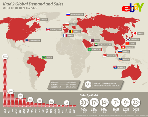
sales of iPad 2s abroad

I must admit to being a bit underwhelmed here. Maps are great and all, but here this map adds nothing to the story except that I can now identify where Poland is. It’s an island country north of Belgium. Or is that France? Wait, what is this lonely sticker-tag for the United Kingdom out in the Atlantic? The data encoded in the map is already present in the datagraphic, if you look to the bar chart of iPad shapes in the lower left quadrant.

But the bar charts do confuse me, I very rarely like using symbols of things for measuring precise numbers of things when those symbols of things represent a number of things more than just one thing. (And that is about as confused as I feel.) And then on another level, I have to strain for a moment to figure out what these three-letter identifiers are. As it just so happens, there is a standardised set of country abbreviations in both two and three letters. When I see UNK, I immediately think Unknown. And RSS makes me think of RSS feeds. Neither connects me to the United Kingdom or Russia.

In the bottom right is the breakdown of sales by model type. Here, where the treatment is simpler we see more success at clearly communicating the information. Could it be more succinct and a touch better organised, yes. But, in all, this is clear and effective. Ergo, it works.

Interestingly, cnet also posted the previous year’s infographic by eBay for sales of the first iPad.

sales of the iPad abroad
sales of iPads abroad

Very loosely (and quickly), I think it is more successful and tells more data. The data on the map, like this year’s, need not be communicated by a map, that much is true—why are the countries two shades of blue, I have no idea if that encodes data. However, the same data is also duplicated in the chart in the lower left quadrant, but here far more succinctly and far more accurately than by weird symbols of the iPad. Last year’s infographic is missing the breakdown by model type, however, instead of those six datapoints, here we have a timeline of iPad sales that, it is safe to say, references more than six datapoints.

In a sense, eBay took a step backwards in their infographics. A pity, because one imagines that if they have the sales data for time periods, they probably have other sets of data that would make for an interesting and richer piece.

Credit to the designers at eBay and cnet for posting the article.

Pie Charts v Bar Charts, Round…Some Really High Number

Not strictly a commentary on a piece or project, instead, this is a link to an interesting opinion piece about the Great Infographic Debate, i.e., most loosely and least helpfully, substance vs. style, vis-a-vis the use of pie charts and such vs. bar charts. Where does one draw the line between clear communication and, frankly, just getting somebody’s attention so that one can communicate?

From the article, an illustration of just how bar charts are significantly better than pie charts at clearly communicating data such as which is the largest data point.

The largest datapoint is obvious, but what about the order of those that follow?

Thanks to Ben for the heads up.

Counting People

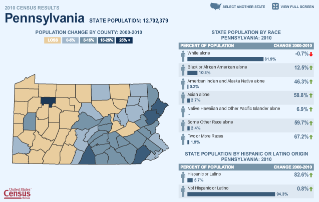
The Census Bureau has been releasing state population figures over the past several weeks and one means of accessing those figures is through a small, interactive map feature. Clicking through makes for some interesting observations—although not all states are currently available. In this screenshot, one can see an interesting story. Western Pennsylvania is shrinking whereas eastern Pennsylvania is growing. And, perhaps importantly, Philadelphia has perhaps reversed its long-term trend of population decline and saw a 0-5% increase in population while its further suburbs have seen increases in the 5–25% range.

census map feature
census map feature

If one is not viewing the piece in fullscreen mode, the navigation can be a bit small, especially for small counties. And the counties over which one rolls with the mouse cannot be selected, they are purely rollover functions that display census data from 1960 and the total population as of 2010. I would have liked the ability to select a particular county and then compare it to others by rolling over neighbouring counties. The colour choice, blues and a light, brownish-beige work rather well within the overall blue motif of the site. And by restricting the palette there, one gains the ability to use an altogether different colour, here green, to indicate which counties are rolled over along with differentiating the rollover box from the remainder of the map piece.

I wonder if more could not have done with the ethnic breakdowns on the right. Certainly the overall breakdown is effective, but it appears to lack a summary of sorts. What was the overall change for the state? And on a minor note, the person symbol is downright distracting.

To get to the first state, one clicks on said state from an overall map of the United States. States are blue if they have had their data released, grey otherwise. However, once looking at a state, there is no way back to the overall map as states are chosen from a small button in the upper-right. This works just fine, we are here to look at state data, not for a geography lesson. However, that they use the map at the beginning seems incongruent with the remainder of the experience. I wonder if they could not remove the map at the start, or keep the map but make it more useful. After all, it would be interesting to see the percentage change in the states displayed—the unpublished states could remain grey.

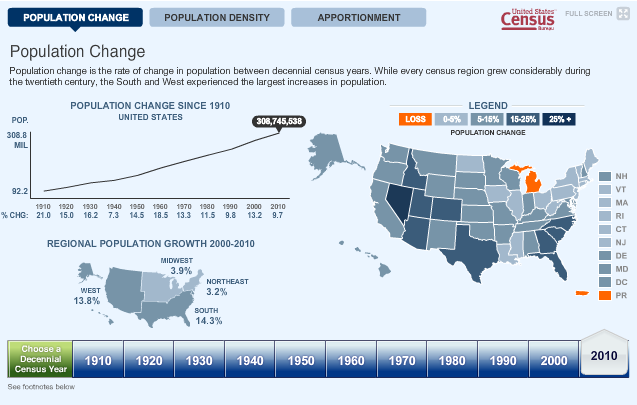
Further below the first map is a second map.

Census map 2
Census map 2

Here, one does have access to the state population change figures. Much of the critique above remains salient here, except the light brown for population loss in the first map is here replaced by a garish and obnoxious orange. An interesting addition is the range of historical data, from the 1910 census through the 2010 census and to see how those population changes affected the apportionment of seats in Congress. Another interesting story that one can glimpse is the ‘filling-in’ of the North American continent. Population density in 1910 was high only in the Northeast, but ever since, the people have spread, concentrating along the coasts and then moving inwards towards the vast centre of the continent.

Rule, Britannia

The United Kingdom. England. Britain. All pretty much mean the same thing, right? No. But, if you do not believe me, might I recommend going to Glasgow or Edinburgh and calling a local an Englishman. It may very well be a quick education.

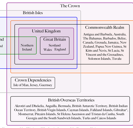
Colin Grey attempts to untangle the constitutional and jurisdictional mess in both a video and an accompanying chart. The video takes about five minutes and is largely correct with most of the errors I have picked up on being rather small in nature, e.g. Ireland is not the Republic of Ireland but just Ireland…not a big deal unless one wants to be enraged by minutiae.

The chart is simple and effective in delineating the structure of the UK and expands about how the UK fits into Europe.

Breaking Down the United Kingdom

Credit for the piece is to Colin Grey and thanks to Kim Nguyen for the tip.

Radiation…Tastes Like Metallic Tang

It is a mad, mad world out there these days and I suppose this is the point at which we all begin to run around shouting that the sky is falling. Despite all the madness in Libya, the constitutional referendum  in Egypt, the protests in Syria, the election in Haiti, and the president’s overseas trip to Brazil we still have the aftermath of the Sendai earthquake and the subsequent Pacific tsunami. The latter being particularly important because of the damage to the now infamous Fukushima Daiichi nuclear generating station in northeastern Japan.

Fukushima will likely be up there with the three other major nuclear disasters of a power station variety: the Windscale Fire in Cumbria, England; Three Mile Island outside Harrisburg, Pennsylvania; and of course, Chernobyl in the Ukraine (then the Soviet Union). We sometimes have heard the media compare Fukushima as the next great nuclear disaster, but how bad has it really been?

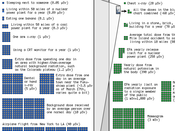
This graphic by XKCD comes to me via my coworker, Brian Morgan, and it breaks down our average exposure to ionising radiation—the bad stuff—from nuclear accidents from Chernobyl to Fukushima to x-ray machines to the natural radioactivity in the soil. Yes, you are likely being irradiated as you read this post.

A cropping of a radiation dose chart

Radiation is bad. But we will all find better solutions to problems if we keep our fears both in proportion and in check. Fukushima is not good. But it is far, far from the end of the world.

…to the Shores of Tripoli…

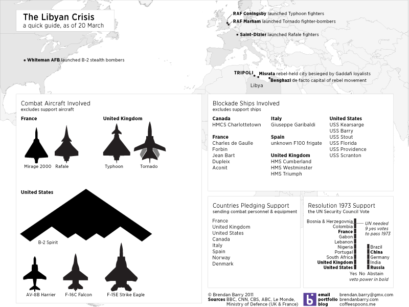
Two hundred years later, and the US Navy is again in action off the shore of Tripoli. Except instead of calling it the Barbary Coast, we now typically see the name the Maghreb. Things will surely be fluid and changing far faster than I can hope to detail in graphics, let alone follow casually. However, this here details what I have learned since this morning. Nothing too fancy, just mapping out some places to show just how far American, British, and French warplanes are flying to reach Libya. Then what aircraft are being used, at least that we know of, what ships are in the blockade and lastly who supported the Resolution 1973.

Detailing the Libyan Crisis as of 20 March

By Monday we shall surely be seeing further attempts by news and media agencies.

A (Multiethnic) Apple Falls Not Far From The Tree

One of my interests is genealogy/family history. While everyone is certainly more than the sum of their parts, that sum of parts is the history that led to your existence. And I find that notion fascinating.

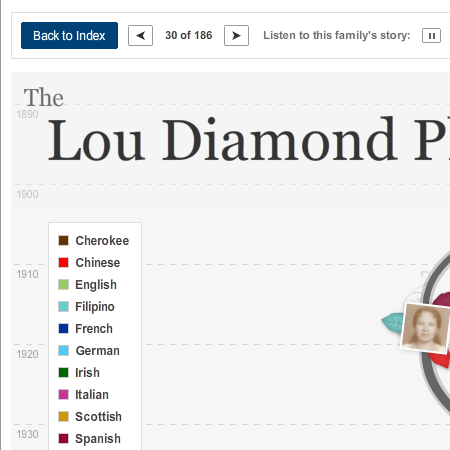
When looking around the New York Times, I came across this interactive piece about complicated family histories. I am unaware of the exact impetus behind the project, but it probably has something to do with the unfolding US Census results and the increasing number of mixed marriages and thus genealogies. But I cannot say for certain.

Lou Diamond Phillips Genealogy

The design of the piece is an interesting decision. Instead of a complicated and unwieldy diagram with lots of details, the designers chose to focus merely on photographs, when available, and little, coloured leaves to denote the ethnicity of each individual. This works to a degree in communicating simple ethnic ancestries, however, when one begins to have shades of light blue to distinguish between disparate ethnicities, one can begin to see a flaw in the system.

From an interactive perspective, I certainly think one of the more interesting bits is the inclusion, at least here in Lou Diamond Phillips’ tree, is the inclusion of the audio story as recounted by an individual. It brings a level of human connection that is always lost in diagrams. (Although these diagrams do have softer, curvier lines than most ergo they are more human. No?)

As someone interested in genealogy, the details are a bit light—but that was not likely the main intent of the piece. Beyond that, there are privacy issues with which to contend. But, if you wish, the New York Times does allow you to upload your own tree and even audio—to 10 megabytes. Perhaps in the future I shall upload a simple version of mine.

All in all, an interesting piece.

You Say You Want a Revolution…

If you have been living under a rock—or perhaps I should say isolated at an oasis deep in the Sahara—you may not have heard that these are some interesting times in northern Africa and the Middle East. Popular protests begat revolutions that have now toppled two governments, Tunisia and Egypt, and quite possibly a third in the near future, Libya. And for those that have not seen governments fall, Bahrain, Yemen, Algeria, Jordan and Morocco have all been disrupted to some degree by protests against the governments in power.

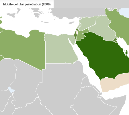
Perhaps one of the defining characteristics of these movements have been the social-networking and mobile communications that spread the news of protests, riots, and crackdowns like wildfire. Sites like Facebook and Twitter were instrumental in passing word and for many other, people simply used their mobile phones to spread the news.

CNN has this series of maps to highlight internet and mobile phone use in the region. Nothing particularly fancy about the maps, though I wonder about the choice of green to represent so many Arab nations. Intentional or coincidence? Regardless of the colours, I think these maps are an example of using simple informational-based graphics to support a story. And given the goings-ons in the world, I thought this worth posting.

Internet and Mobile Phone Use in Northern Africa and the Middle East

From CNN via a post at the Map Room.

Having Your (Presidential Birthday) Cake and Eating It Too

Presidents’ Day originally celebrated the birthday of George Washington, the first president of the United States. (Though, one could get crazy and say it was actually Samuel Huntington, but I fear I would digress.) Now technically the holiday still does celebrate Washington as the official name of the federal holiday is Washington’s Birthday, but by and large we group folks like Lincoln in there too.

Regardless of who exactly is remembered, we remember a United States of the 18th and 19th centuries. And thus it seems appropriate to share a piece from Charles Blow over at the New York Times.

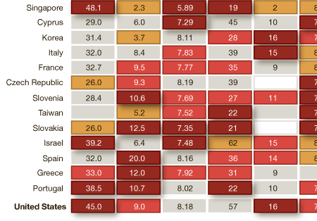
United States' Ranking

The information graphic is a heat chart of various rankings and index numbers that compare the United States across various metrics to the rest of the world’s “advanced economies”, as decided by the IMF. I certainly have some issues with a few of the metrics, for example what exactly does Gallup mean by percentage of people thriving? And are the math and science scales out of 600 total points? I presume as much but cannot be certain. These could have briefly explained in the footer, or similar to how the food insecurity metric is handled—though I suspect that would be too much from an aesthetic standpoint. The use of drop shadows, from a design perspective, I disagree with; the dark crimson should surely be enough distinction to stand alone. And for completeness, I would have included what appears to be the beigish middle ground between the best and the worst in the scale at the top of the piece.

As to the story the piece supports, I leave that for the audience to decide. Is the United States of the President Obama/Bush as great as that of President Washington/Adams?

If Money Grew on Trees…

I would have become an arborist…alas, I am a mere designer in a world where trees shed leaves, not cash. The government, on the other hand, now that sheds a lot of cash.

President Obama released his budget proposal for 2012, proposal because the responsibility actually falls to the House of Representatives to pass spending bills and budgets. The New York Times, crediting Shan Carter and Amanda Cox, has put together a nice little interactive piece explaining the proposal. (It would be rather interesting to see if they compare the proposal to the passed budget, whenever that happens.)

Cropping of the US Budget for 2012 (Proposed)

From one side of the aisle we hear arguments about how we must cut spending from things like education and infrastructure while the other side pushes back. However, what this piece does quite nicely is allow the user to isolate mandatory spending. That is, we see that if we really wanted to cut spending, we would need to look at reforming Medicare, Medicaid and Social Security and then cutting the Defense Department budget. At last, something on which we see bipartisan agreement, reforming and cutting those budgets is too tough (read likely to cost representatives, senators, and presidents their jobs) and so they are left alone. But, I digress.

Furthermore, the piece adds the change in spending since 2010 for the various programs by way of greens and reds. While certainly not necessary—one could argue that the inclusion of such data makes a sometimes difficult chart type that much more difficult—I think that in this case the additional data is more than worthwhile. This year’s theme seems to be austerity and that means cuts. So while highlighting, say, the massive portion of government spending that is Medicare, Medicaid, and the US military we can also highlight that much of all that spending is still rising.