Finnish Election Results

Finland held an election that was worth watching because of the rise of a nationalist party whose name translates to True Finns. The leader of the True Finns was interviewed and at the end he reassured all watching that they “are not extremists. So you can sleep safely.” For Europe, the issue is their opposition to the bailouts of the various European economies, such as Ireland and Greece. And now that Portugal is in the midst of bailout negotiations, the True Finns could complicate matters if they manage to make it into government.

The Finnish Ministry of Justice released a small, interactive piece detailing the results. The parties are represented by acronyms, with PS for the True Finns. And here one can see that they performed third-best with about 19% of the vote. The True Finns actually beat the Centre Party, which was the leading party in the last coalition government. In short, a remarkable rise whose impact is yet unknown.
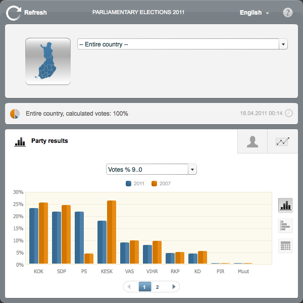
Overall Vote in Chart Form

The interactive piece, however, is a tad confusing. While one story is certainly the improvement of the True Finns from the last election to the current one, does that need to be shown in the default view as we have here? And what I perceive to be shading or some sort of split colouration in the bars lends itself to the idea of having two separate sets of data encoded in the bar. Although I can see no such data and am thus confused.

But, fortunately, one can also change one’s views of the data, from column to bar to table. And I daresay that the table, in this instance, I find best. Not because the data could not be visualised in an interesting, compelling and comprehensible fashion, but because it was not.
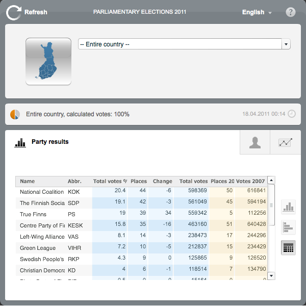
Overall Vote in Table Form

Certainly, the election results provide interesting data sets. And in this case we clearly have an interesting story, the rise of the True Finns from a small, rural party of 5 seats in the Finnish parliament (200 total seats) to the third-largest party with 39 seats. Alas, this piece leads does not make it easy to tell that story—let alone the results of the election.

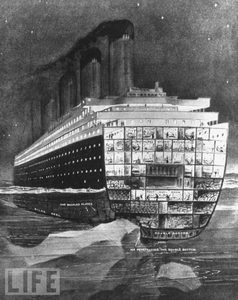
RMS Titanic, 99 Years Ago

99 years ago today, the RMS Titanic sank in the North Atlantic with more than 2/3 of the over 2200 passengers losing their lives. The ship was rather state-of-the-art and was considered remarkably safe with more lifeboats than was legally required for the passengers and crew. She also had a number of watertight bulkheads that could contain flooding and keep the ship afloat even if a remarkable total of four such compartments were flooded.

TItanic Cut Away Where the Berg Hit

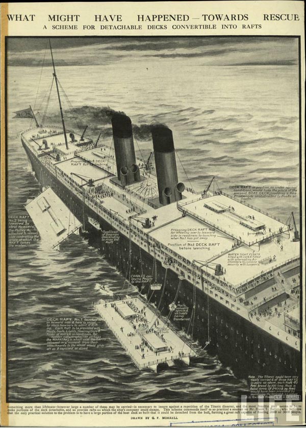
But as we all know, the iceberg, frigid water, and brittle steel combined to flood not four, but six compartments. And while more than legally sufficient, the number of lifeboats and passenger space was insufficient to save all the passengers. This illustration, by G.F. Morrell details how floating catamaran deck rafts could have saved lives.

Proposed Change to Ship Design

All photos from Life.

The Country’s Most Violent States

Do you live in a horribly violent and crime-afflicted state? Do you want to know? Well there’s a map for that.

US Peace Index Map
US Peace Index Map

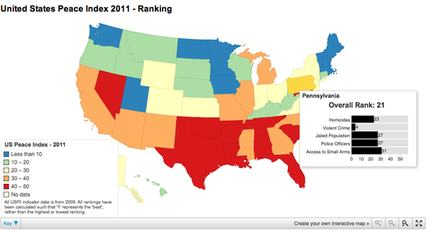
From the Guardian, here we have a familiar choropleth that colours each state based on where it falls into the range from most peaceful, Maine and Vermont, to the the most violent, Louisiana and Tennessee. The map was developed using a site called chartsbin from data provided by the Global Peace Initiative.

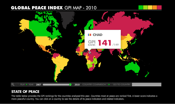
In short, nothing fancy, but an interesting topic to visualise after the earlier world rankings. Truth be told, I think the added data in the rollover state for the US states is more meaningful than the big rank number and flag that appears in the global version.

Global Peace Index
Global Peace Index

Shutting Down Nuclear Reactors

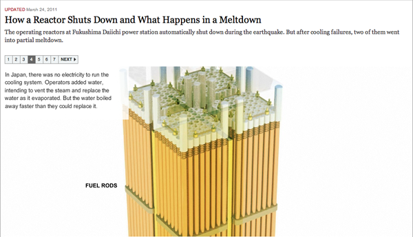
Japan has updated the the threat level from the Fukushima Plant from five to seven. And while everyone ought to put Fukushima into context, chiefly by looking at the damage facing the rest of the country, we can also see that, broadly, things worked as expected at the power plant. They just did not build the plant to survive the 48ft-high tsunami waves and 9.0 earthquakes that happen perhaps once every thousand years. Very poor planning indeed.

This is an older, albeit by a few weeks, graphic from the New York Times explaining how a reactor is ‘shut down’ and then, failing that, what a meltdown is. And most importantly, how the meltdown of a modern reactor design is far different from that at Chernobyl.

Shutting Down a Nuclear Reactor

Credit for the piece to Xaquín G.V., Bill Marsh, Dylan McClain, and Graham Roberts.

Useful Africa

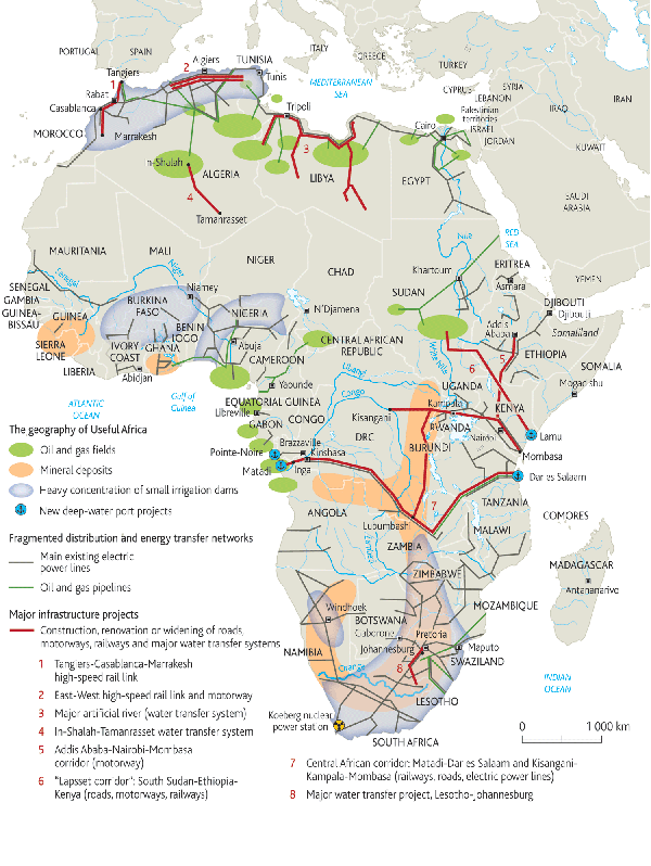
Another rather recent infographic from Le Monde’s Philippe Rekacewicz is this, called Useful Africa.

Useful Africa
Useful Africa

One of the key problems for African development is its lack of infrastructure. Here we see the proposed and under-construction projects that will hopefully raise Africa up from its current state. But the infrastructure is only as good as it is economically useful. Hence the connection between those same infrastructure projects and areas of mineral or hydrocarbon reserves.

This is an example of where a map is incredibly useful, as opposed to say a choropleth that shows which countries in Africa have the highest concentrations of oil reservers, of natural gas reserves, and of mineral reserves. The geography here is key to understanding the transport links between major population centres, ports and points of distributions, and the raw materials to be exported—if not processed and refined.

Maps Made by Hand (Or Simulations Thereof)

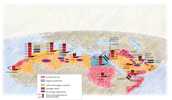
Le Monde is a French-language publication and so I never really bother with it, despite favourable reviews. However, they do have a small site with some content in the English language that I check from time to time. Frequently they have maps or other graphics of some interest, and this time upon visiting—done to see if they have anything on Libya given the lead taken by France and the UK—they had a few maps of the situation in North Africa.

Political Situation in North Africa and the Middle East

By and large, nothing radical or ground-breaking in the maps. But, the designer, Philippe Rekacewicz, used a different cartographic perspective than I am at least accustomed to seeing for infographics. And then the aesthetic of the map is interesting, and quite different than what one typically sees. In a refreshingly interesting way. Now, whether he used a texture or filter in Photoshop to create the background map or whether he physically drew the map (and then overlaid the informational elements digitally), it matters little as the style works. I enjoy the idea of mixing the hand-made and data visualisation—though it needs to be well-executed.

He created a few sets of maps; each makes use of a slightly different palette. These certainly help create the visual distinction necessary between data sets. The pie charts are not particularly helpful, but they at least are kept simple: looking at only two parts of the whole. The comparison within each nation by bar charts of internet connectivity and higher-education learning works. It begins to work not so well as one tries to compare country to country. Though, the separation of the bars into ten-percentage point sub-bars begins to alleviate that issue. The main map, that highlights the political situation does a nice job of putting these countries into broader context. That is, who has oil and who has control over the key waterways in the region.

the three smaller maps

All in all, a refreshing set of maps that illustrate the fluid situation in North Africa and the Middle East.

Little Red (or blue or yellow or light-blue) Riding (neighbour-)Hoods

While not new news, if you have not heard, Canada’s minority government fell and Canada is having an election. And, as we all know, elections mean infographic insanity. Map mania. Graphs galore. You get my drift.

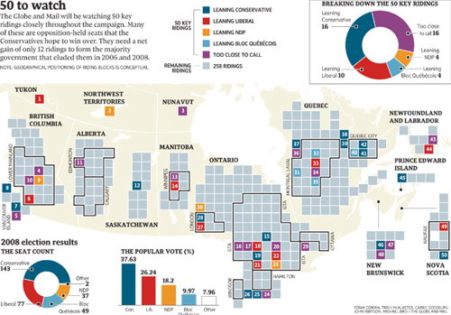
The Globe and Mail, a Toronto-based newspaper, printed an infographic about the 50 ridings to watch. (A riding is, for my mostly US-based readers, similar to a congressional district.) They complemented this with an online, interactive piece. They did all of this a few days ago.

the print version
the print version

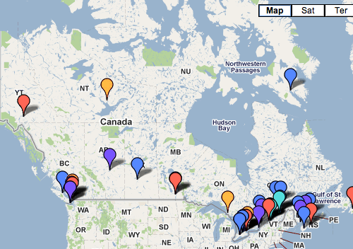
I have been meaning to write about this for a few days, but am only now sitting down to write it up and an interesting thing has happened. Whereas before, I was able to click the Globe and Mail’s link to their print graphic, now I get directed to their Google map pushpin overlay. Bye-bye, print graphic.

online version
online version

And that is a shame, because, the print graphic is far better than the interactive. Yes, the pushpin can be clicked to read a small snippet of summary about the riding, however, at the same scale of print graphic, good luck finding all the pushpins. And while one can certainly zoom-in to find all the urban ridings, one loses seeing the whole and that riding’s relationship to the rest of Canada. Compare that to the print graphic where equally-sized boxes represent the ridings, and the boxes are spread out across a map of Canada in the background, showing the total apportionment of ridings to the provinces and territories. Whereas the pushpins do not. The arrangement of the boxes also has urban ridings grouped together and delineated from more rural ridings. Whereas the pushpins do not. And the boxes are not tied specifically to a point. Whereas the pushpins are. And that is most helpful, because one can only assume that the Western Arctic riding is located inside Yellowknife’s city hall. Right?

Pushpins are great for locating a specific point. Note the point of the pin. The boxes are great for eliminating the distorting effects of electoral districts in rural vs. urban settings. For comparison, look at the congressional districts in and around cities like New York and compare them to those in places like Montana.

I think the print graphic is better also because it included three charts that summarised and provided context of the 50-key ridings in the context of the whole general election across Canada. Google’s pushpin map overlay thing…does not.

Is the print graphic perfect, no. As I noted above, it does not specifically name the 50, as one can discover by clicking on the pushpins. Nor does it provide the name of the candidates or a very brief summary of the situation, as one can discover by clicking on the pushpins. But I have a better grasp of how the little piece fits into the whole from the print graphic.

Perhaps the best solution would have been to create a unique interactive piece that married the best of both designs. Scrap the Google maps bit and create a set of interactive boxes that mirror the print graphic, and so by clicking on the boxes one can access the same information in the pushpin. And then one would also have a reason to write something in the print article about checking the website for the online version that has even more information. But that is surely crazy talk.

As an additional point of comparison, the two screenshots are both roughly the same size in width—the main concern in showing all of Canada—and just note the amount of data presented in both versions.

A more interesting question, though, is why was the print graphic was removed from the site? (Or at least made so difficult to find that I could not find it.)

Credit for the print graphic image I have is to the Map Room, which is from where I first learned of the map to begin with.

Complex Nigeria

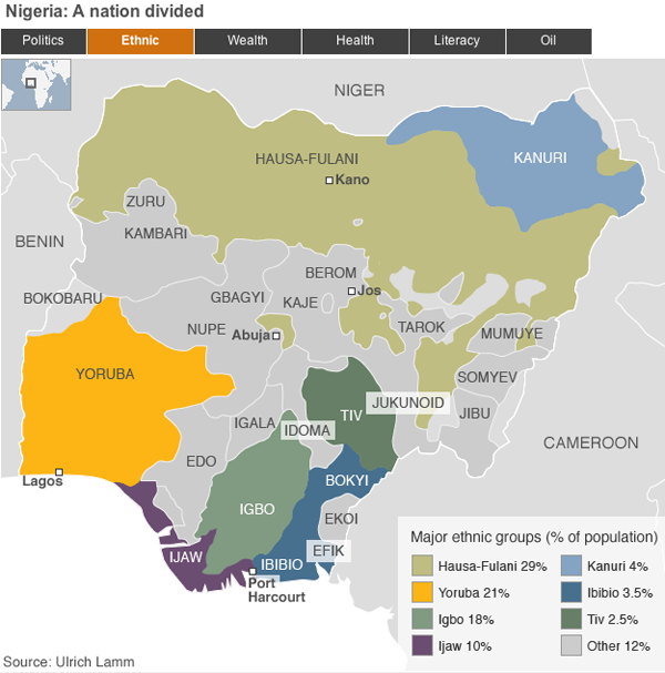
The BBC has a new feature on Nigeria, one of Africa’s most important—and most complicated—countries. And a few days ago it was supposed to hold elections. But these have been postponed, apparently on logistical problems. This piece attempts to explain the complexities of modern Nigeria across several different metrics via maps. Overall, it is very similar to a piece I mentioned that the BBC ran on South Sudan in the run up to that soon-to-be-country’s independence referendum.

Map of Nigeria by Various Metrics

Overall, the piece works for me as a means of quickly and broadly explaining the geographic breakdown of Nigeria in terms of ethnicity, politics, health, et cetera. The colours work, especially shifting between hues for the one-variable maps. The one thing that the Nigeria map adds over the Sudan map is the name of each state. However, these begin to become a bit cluttered and distracting—not to mention that in all-caps they sit at roughly the same level of the neighbouring country names despite being a touch smaller. Perhaps the maps could have been made to do more with less, and only label those states mentioned in the explanatory text. Or they could have been included but treated in a subtler fashion.

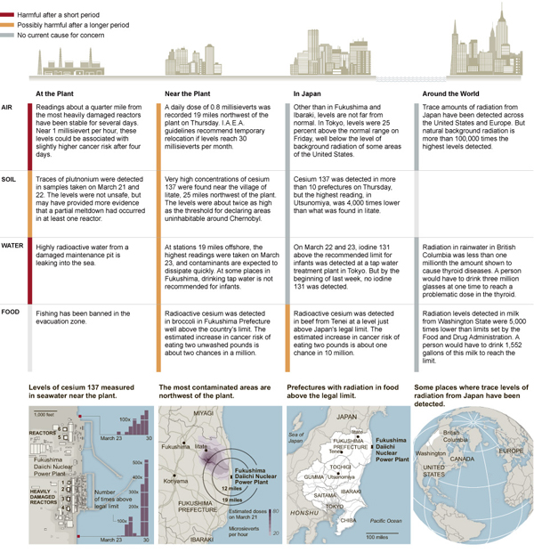
Japanese Radiation in Perspective

Japan continues to deal with damage from the earthquake and its subsequent tsunami. Yet, much of the news that seems to come out of Japan focuses on the leak of radioactive materials from the Fukushima power station. Certainly that is a story, but is it more important than the tens of thousands of people missing and presumably dead?

The New York Times printed a graphic on Saturday that details the danger from the radiation at the plant, near the plant, across Japan, and then across the rest of the world.

Radiation Graphic Reduced

And largely, if you live in the United States, you have no reason to fear the radiation leak. In general, unless you maybe live near the plant, you have no reason to fear the radiation leak.

Overall, it communicates its message clearly and adds nice detail in the bottom third of the graphic about whatever spread of radiation there has been.

Credit for the graphic goes to Joe Burgess, Amanda Cox, Sergio Peçanha, Amy Schoenfeld and Archie Tse.