Campaign Contributions

On 21 May, Angelenos went to the polls to elect the next mayor of Los Angeles. The contest followed an earlier vote that prompted the day’s run-off election. This graphic from the Los Angeles Times examined the contributions to the campaigns of the two finalists, Eric Garcetti and Wendy Greuel.

The overall piece features an interesting interactive component that allowed the user to switch from a scatter plot view to a stacked bar chart view and then filter those results based on whether they were direct or indirect contributions. Generally speaking, that element worked. However, I want to focus on the second big component: an interactive tree map.
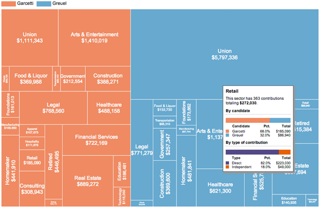
Tree map with rollover

While not all tree maps have to be squarified, by converting datapoints to (roughly) similar shapes the user should have an easier time comparing the area of the objects. This tree map is not squarified and so the user must strain to convert all the different shapes into roughly equal shapes for a visual comparison. Nor is there an inherent ranking within the map—at least not that I can find. That would also help.

So while the tree map is not a success in and of itself, the rollover condition makes for a more interesting overview of the different sectors of contributions. But despite this added value in the rollover,  the data powering the tree map would still be better presented in a different format.

Credit for the piece goes to Maloy Moore and Anthony Pesce.

Testing the Atom Bomb

The Washington Post looked at the testing of the first atomic bomb at White Sands. Nuclear weapons are a topic on which I have done some work in the past. But this piece looks more at the historic test called Trinity.

Trinity Test
Trinity Test

Credit for the piece goes to Alberto Cuadra and Laris Karklis.

Dunkin Donuts vs. Starbucks

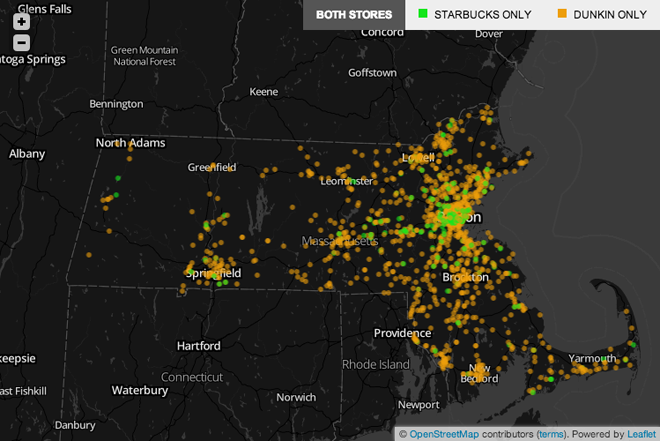
I’m not a coffee guy. I drink tea. At most I have one or two espresso drinks per year. But up in Boston, they have been looking this week at coffee preferences. The question is which is your coffee spot? Dunkin Donuts (from Massachusetts) or Starbucks (from Washington)? Northeast or Pacific Northwest? In a piece that reminds me of the New York Times’ Wawa vs. Sheetz graphic, the Boston Globe plotted the locations of the two national coffee chains. This interactive piece allows you to toggle between dots for Dunkin Donuts (orange, naturally) and Starbucks (green, of course).

Dunkin Donuts vs. Starbucks in Massachusetts

They complemented the Massachusetts-focused piece with a longer article that looked at the national distribution.

Dunkin Donuts vs. Starbucks between New York and Philadelphia

Credit for the piece goes to Alvin Chang and Matt Carroll.

Piracy on the Seas

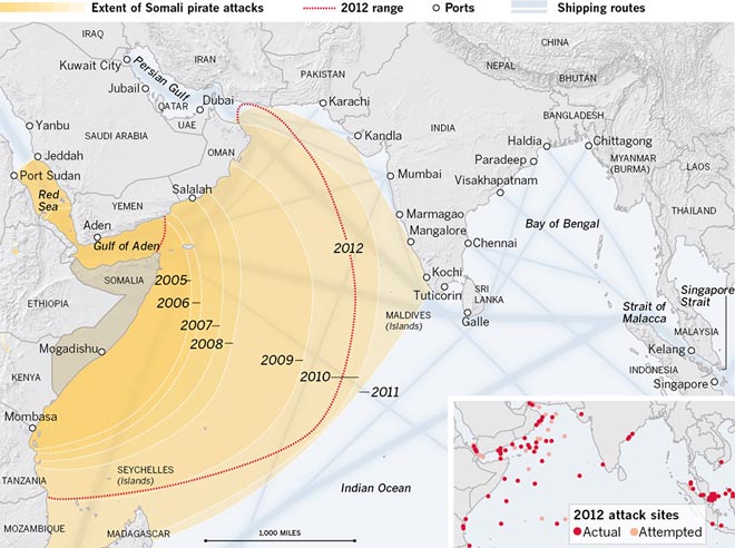
Today’s post looks at an interactive graphic from the Los Angeles Times. The subject matter is piracy and the piece has three distinct views, the second of which is displayed here.

Pirate attacks in the Indian Ocean

Generally speaking, the package is put together fairly well. My biggest concern is with the first graphic. It uses circles to represent the number of attacks by locale over time. I would have either included a small table for each geographic area noted, or instead used a bar chart or line chart to show the progress over time.

Credit for the piece goes to Robert Burns, Lorena Iñiguez Elebee, and Anthony Pesce.

The Cost of Chicago’s Gun Violence

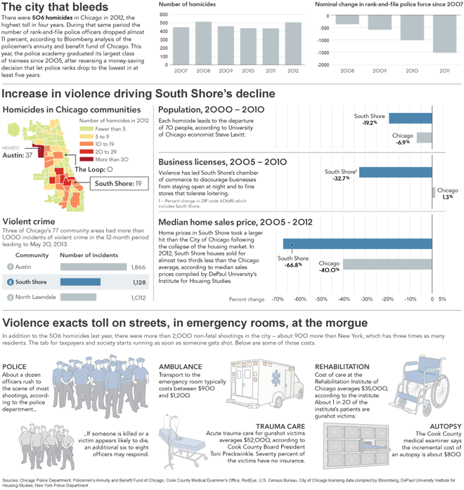
Today’s piece comes from Bloomberg and looks at the cost of Chicago’s gun violence epidemic. And when I write cost, I mean just that. While the lives lost are the most significant, Bloomberg’s article states that shootings cost Chicago $2.5 billion per year, or $2,500 per household. They supplemented their article with an infographic detailing and breaking down these costs by focusing on the South Shore in the city’s south side.

The cost of Chicago's gun violence on the South Shore

Credit for the piece goes to Chloe Whiteaker, John McCormick, and Tim Jones.

A (Time and) Space Race

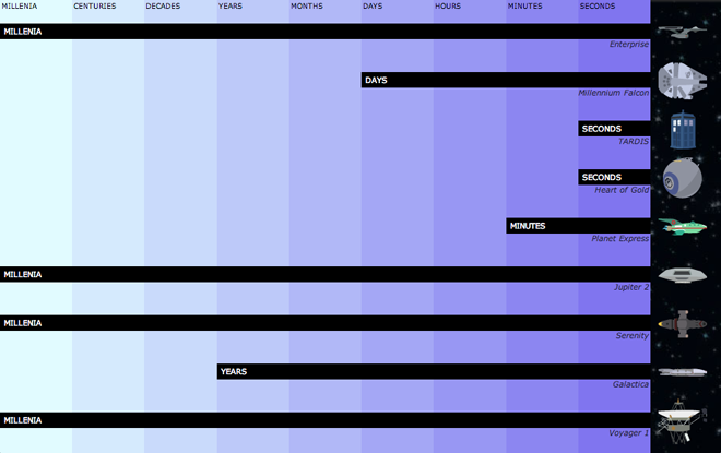
First of all, I grew up a fan of Star Trek and not Star Wars. Star Trek is, after all, more science-y. Now, for today’s post, I could make references to the battlestar Galactica, the good ship Tardis, Planet Express deliveries, or avoiding the Alliance throughout the Verse. Instead I’ll just submit this interactive graphic from Slate.

Voyager 1 is slow
Voyager 1 is slow

It compares the times needed by various nerd-loved starships/spaceships/space vehicles to reach very distant (and real) stellar destinations. Don’t worry, there is a bar chart in the end with Voyager 1 thrown in for comparison to reality. (Though I suppose they could have just made it Voyager 6.)

Not accounting for differing technologies or laws of physics

See, a bar chart. It fits within the scope of this blog.

Credit for the piece goes to Chris Kirk, Andrew Morgan, and Natalie Matthews.

Changes in Global Life Expectancy

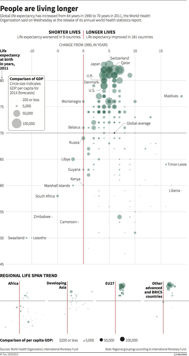
Today’s post is a scatter plot from Thomson Reuters looking at changes in global life expectancy since 1990. What is really nice about this piece is the main space for the data visualisation presents all of the data for all of the available countries. Beneath the main visualisation, the designer chose to use small multiples of the same chart to highlight broader regional trends.

Change in global life expectancy

Credit for the piece goes to, I think, Hwei Wen Foo. (Credit on the graphic is W. Foo.)

Scatter Plots in Time (and Space?)

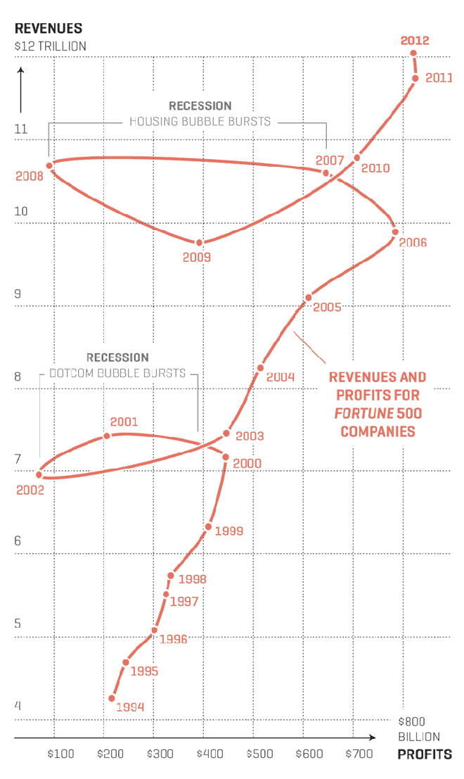
Well maybe not so much the space. Anyway, Nicolas Rapp, who does a lot of work for Fortune Magazine and previously the AP, created his first connected scatter plot. I have been a fan of them for quite some time and have been able to use them from time to time. Rapp’s scatter plot looks at the profits and revenues of the Fortune 500 in the last 20 years. But what I think makes his piece particularly strong are the two annotations he provides to explain the “loops” in the data: the two big recessions.

Profits and revenues for the Fortune 500

Credit for the piece goes to Nicolas Rapp.

Student Debt Levels are Soaring

Earlier this month the Federal Reserve Bank of New York published a report on household debt. Among the findings was the story that student debt is rising to problematic levels as it may act as a brake on economic recovery. In short, without an economy creating jobs for the young (recent university graduates) it becomes increasingly difficult for the young to pay pack the loans for the sharply rising costs of university tuition.

The report made this argument by use of interactive choropleth maps and charts. The one below looks at

Which consumers have how much debt

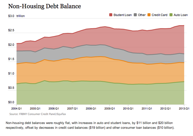
But another chart that talks about the rising levels of student loan debt misses the mark. Here we see some rather flat lines. Clearly student loans are growing, but without a common baseline, the variations in the other types of debt muddle that message.

The NY Fed's presentation of non-housing debt

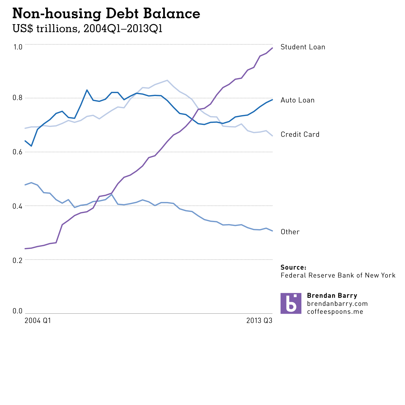
I took the liberty of using the data provided by the New York Fed and charting the lines all separately. Here you can clearly see just how in less than ten years, student loans have risen from $200 billion to $1,000 billion. This as credit card debt is falling along with other forms of debt (non-automotive).

My take on non-housing debt

The New York Fed did some great work, but with just one tweak to their visualisation forms, their story is made much more powerful and much more clear.

Credit for the original work goes to the Federal Reserve Bank of New York.

Alaska Airlines

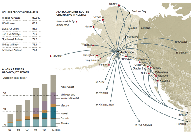
Here’s an older, March graphic from the New York Times that looks at Alaska Airlines. This exemplifies what maps do well; it maps relevant data onto a map. Perhaps that reads silly, but too often people map data just because most things are tied to a geography; things that happen in the world happen somewhere, ergo everything could be mapped.

The growth of Alaska Airlines

In this graphic, however, mapping the tight and Alaska-focused network with tendrils sneaking off-map to distant cities. The map supports the article that tells how after decades of focusing on Alaska, the airline has begun to expand to Midwestern cities in the US, cities in Mexico, and Hawaii.

I am not terribly keen on the stacked bar chart. It highlights the steady Alaska market over the decades at the cost of showing dynamism in those Midwestern, Mexican, and Hawaiian markets.

Credit for the piece goes to the New York Times Graphics Department.