Double Your Hurricanes, Double Your Fun

In a first, the Gulf of Mexico basin has two active hurricanes simultaneously. Unfortunately, they are both likely to strikes somewhere along the Louisiana coastline within approximately 36 hours of each other. Fortunately, neither is strong as a storm named Katrina that caused a mess of things several years ago now.

Over the last few weeks I have been trying to start the week with my Covid datagraphics, but I figured we could skip those today and instead run with this piece from the Washington Post. It tracks the forecast path and forecast impact of tropical storm force winds for both storms.
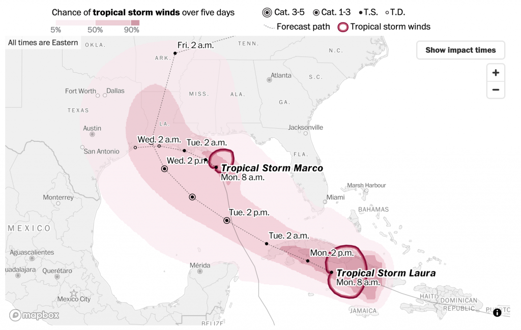
The forecast path above is straight forward. The dotted line represents the forecast path. The coloured area represents the probability of that area receiving tropical storm force winds. Unsurprisingly the present locations of both storms have the greatest possibilities.

Now compare that to the standard National Weather Service graphic, below. They produce one per storm and I cannot find one of the combined threat. So I chose Laura, the one likely to strike mid-week and not the one likely to strike later today.
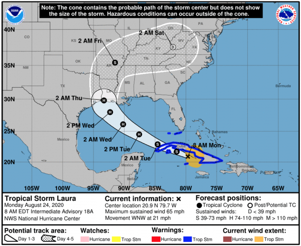
The first and most notable difference here is the use of colour. The ocean here is represented in blue compared to the colourless water of the Post version. The colour draws attention to the bodies of water, when the attention should be more focused on the forecast path of the storm. But, since there needs to be a clear delineation between land and water, the Post uses a light grey to ground the user in the map (pun intended).

The biggest difference is what the coloured forecast areas mean. In the Post’s versions, it is the probability of tropical force winds. But, in the National Weather Service version, the white area actually is the “cone”, or the envelope or range of potential forecast paths. The Post shows one forecast path, but the NWS shows the full range and so for Laura that means really anywhere from central Louisiana to eastern Texas. A storm that impacts eastern Texas, for example, could have tropical storm force winds far from the centre and into the Galveston area.

Of course every year the discussion is about how people misinterpret the NWS version as the cone of impact, when that is so clearly not the case. But then we see the Post version and it might reinforce that misconception. Though, it’s also not the Post’s responsibility to make the NWS graphic clearer. The Post clearly prioritised displaying a single forecast track instead of a range along with the areas of probabilities for tropical storm force winds.

I would personally prefer a hybrid sort of approach.

But I also wanted to touch briefly on a separate graphic in the Post version, the forecast arrival times.
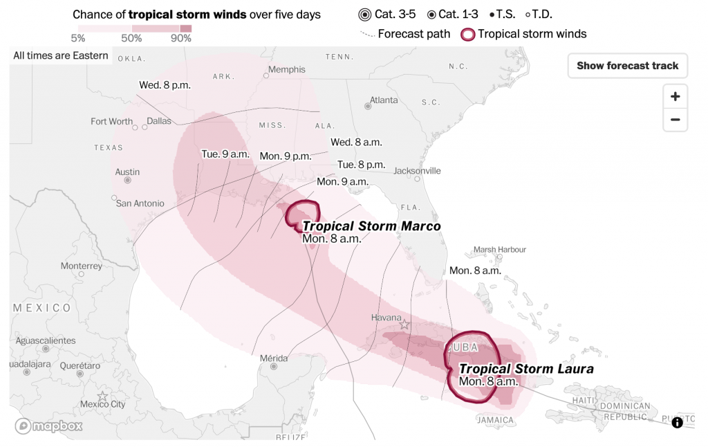
This projects when tropical storm force winds will begin to impact particular areas. Notably, the areas of probability of tropical storm force winds does not change. Instead the dotted line projections for the paths of the storms are replaced by lines relatively perpendicular to those paths. These lines show when the tropical storm winds are forecast to begin. It’s also another updated design of the National Weather Service offering below.
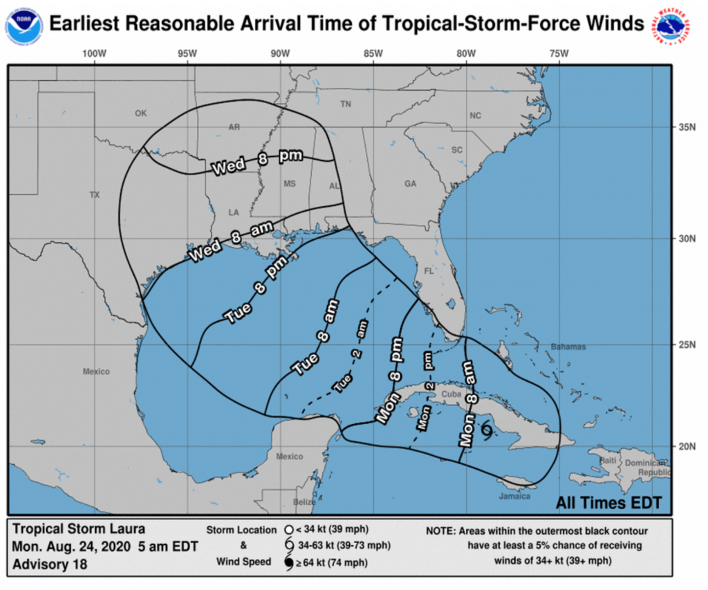
Again, we only see one storm per graphic here and this is only for Laura, not Marco. But this also probably most analogous to what we see in the Post version. Here, the black outline represents the light pink area on the Post map, the area with at least a 5% forecast to receive tropical storm force winds. The NWS version, however, does not provide any further forecast probabilities.

The Post’s version is also design improved, as the blue, while not as dark the heavy black lines, still draws unnecessary attention to itself. Would even a very pale blue be an improvement? Almost certainly.

In one sense, I prefer the Post’s version. It’s more direct, and the information presented is more clearly presented. But, I find it severely lack in one key detail: the forecast cone. Even yesterday, the forecast cone had Laura moving in a range both north and south of the island of Cuba from its position west of Puerto Rico. 24 hours later, we now know it’s on the southern track and that has massive impact on future forecast tracks.

Being east of west of landfall can mean dramatically different impacts in terms of winds, storm surge, and rainfall. And the Post’s version, while clear about one forecast track, obscures the very real possibilities the range of impacts can shift dramatically in just the course of one day.

I think the Post does a better job of the tropical storm force wind forecast probabilities. In an ideal world, they would take that approach to the forecast paths. Maybe not showing the full spaghetti-like approach of all the storm models, but a percentage likelihood of the storm taking one particular track over another.

Credit for the Post pieces goes to the Washington Post graphics department.

Credit for the National Weather Service graphics goes to the National Weather Service.

Reducing Postal Sort Capacity

For my non-American audience, the United States uses a federal system under which its constituent states retain the responsibility for organising and executing elections. And so we have 50 different electoral systems. A select few use the United States Post Office (USPS) to distribute blank ballots to voters and collect them when completed. Five states have used this system without issue for years (and infinitesimally small issues of fraud): Colorado, Hawaii, Oregon, Utah, and Washington.

But with the United States having failed to adequately deal with its Covid-19 outbreak, see yesterday’s post, most US states will be expanding their mail-in ballots to help protect voters and keep them safe. But this all depends upon the USPS. The Trump administration fears losing the election and in a press conference Trump admitted aloud that he wants to withhold funding from the USPS to prevent people from voting.

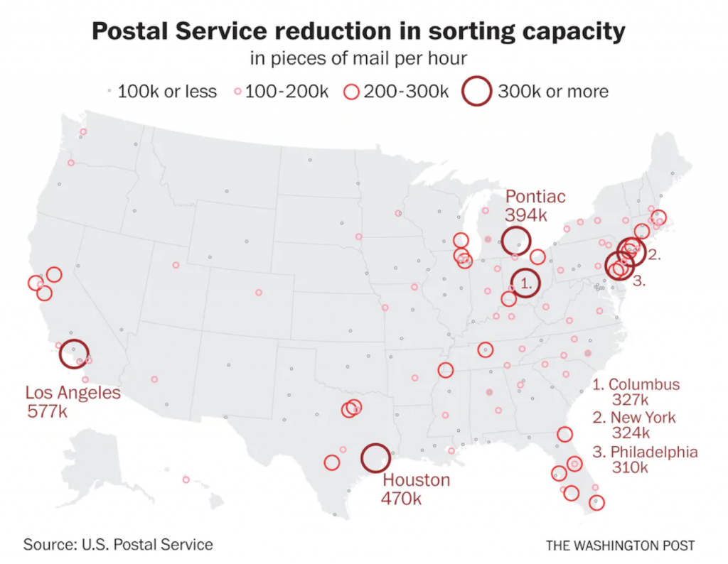
What does that look like? Well, Trump appointed a new postmaster general to carry out his wishes and the Washington Post created this graphic to show where the USPS has reduced the sorting capacity, a critical part of the delivery of postal ballots.

Is this why my mail is taking longer than usual?

Often I will write about how I don’t like the use of circles and their measurement by area.

First, the advantage of the circles here is that they are tied to specific geographic sites, and they do not refer to geographic areas like counties, states, or regions. So in this case, this is a plus.

Second, the circles appear to not be sized by area, but maybe by diameter. I would need more time to investigate this, but the areas look off. But I should add I do like how the largest postal facility impacts are called out by labels, and those in heavily clustered areas are numbered and placed off the southeast seaboard.

Third, I’m not really sure why the colours are necessary, or rather, what changing the colours adds given that the sizes of the circles is already changing.

So while I have some issues with what’s going on here, the content itself is critically important for people to see. Note that a number of the largest postal facilities by impact are located in Ohio, Pennsylvania, Michigan, and Texas. And Florida has a lot of medium-sized circles. And while Texas is likely still a Republican state in the electoral college, Biden is currently polling within a good night’s results’ reach of Trump there. The other states are all solidly swing states up for grabs or with Biden leading by some degree in the current polling.

Credit for the piece goes to the Washington Post graphics department.

Is Covid-19 Surging in New Zealand?

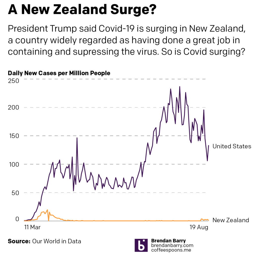
Yesterday, President Trump claimed that Covid-19 was “surging” in New Zealand, a country widely lauded as having successfully contained and suppressed their outbreak. That has allowed Wellington to reopen large swathes of their economy without incident.

Until this surge.

And by surge we mean something like 30 cases in 3 days. So, let’s compare that surge to the numbers of new cases in the United States.

Now, to be fair, New Zealand has a population of nearly 5 million, the United States has nearly 335 million. So a direct number-to-number comparison of the number of new cases per day isn’t fair.

So let’s look at the number of new cases per million people, which equalises the data for population.

So yeah, New Zealand is not “surging”. The data shows that even with the more limited testing per capita conducted in the United States, we are nowhere near the point of bending the curve anywhere close to zero.

Credit for the piece is mine.

Covid-19 Update: 16 August

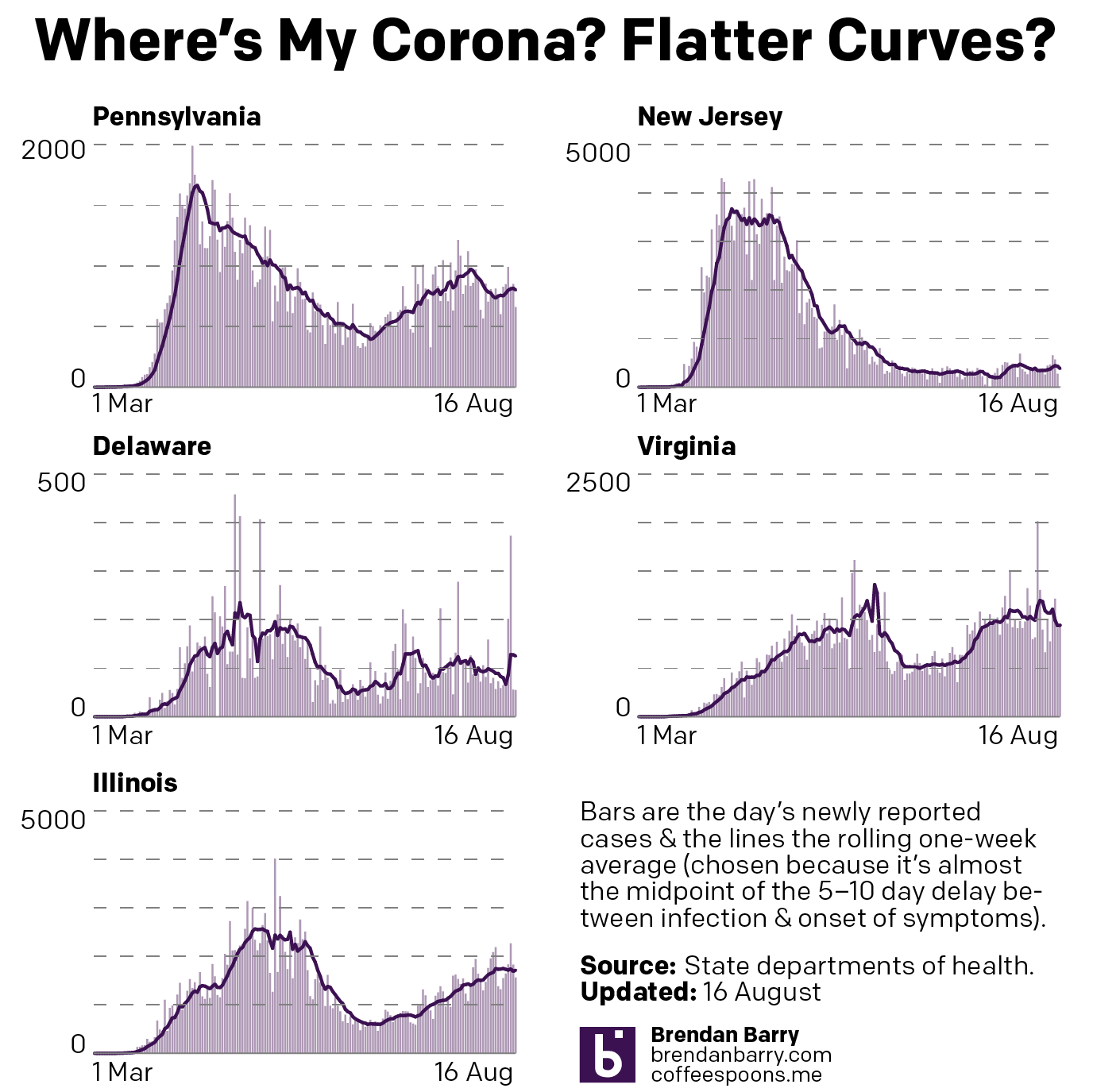
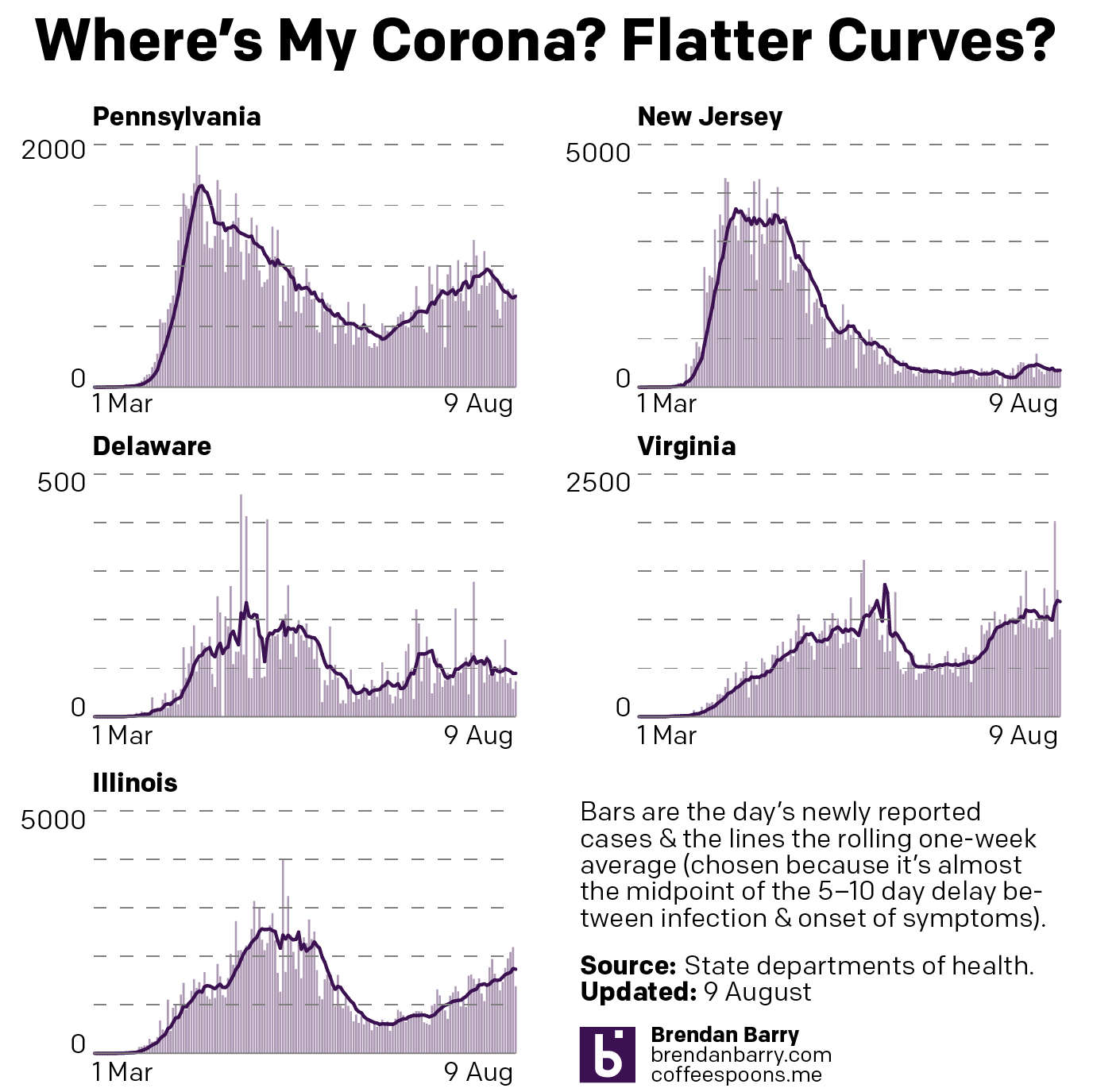
So here are the charts from the last week of Covid data in Pennsylvania, New Jersey, Delaware, Virginia, and Illinois.

When we compare last week’s update to today’s, we can see that Pennsylvania did indeed bottom out and is back on the rise and the same can probably be said for Delaware. Although a fair amount of the one-day spikes in those numbers we see today are from an outbreak in a correctional system.

Whilst Virginia did go up, by week’s end, it had settled back down to a point not dissimilar to last week. So nothing really changed and time stood still in Virginia. The same can also be loosely said for New Jersey, where it was more about fluctuations than determined rises or falls.

In Illinois, however, we finally saw a plateauing of the new cases numbers and with the slightest of declines .

New cases in PA, NJ, DE, VA, and IL.
New cases curve in PA, NJ, DE, VA, and IL.

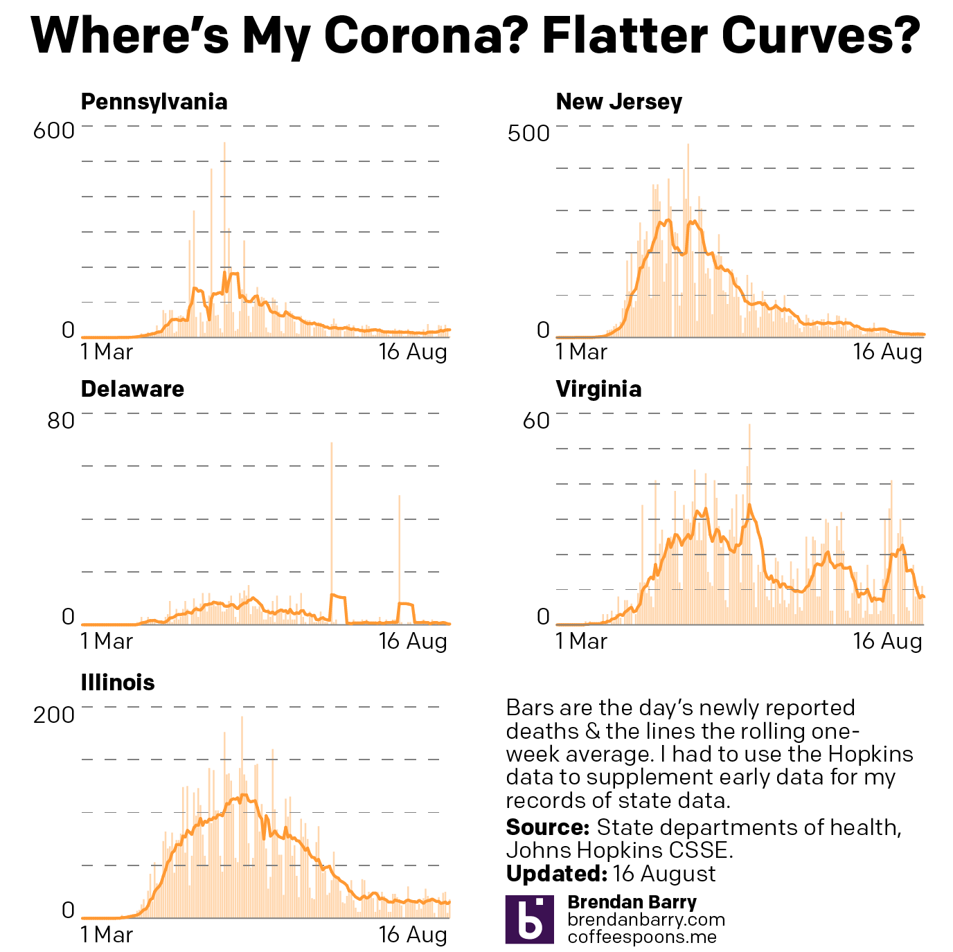
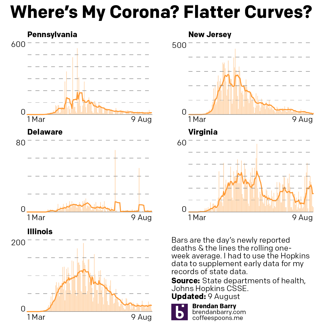
Then in deaths we have not much to say as they remain low in New Jersey and Delaware and stable and moderate in Illinois.

Virginia’s recent spike appears to have subsided, as it’s back to nearly 10 deaths per day from the virus.

But most concerning is Pennsylvania. Here, while the numbers are still relatively low, they are on a slow and gradual rise. At this point the seven-day average is beginning to rise above 20 deaths per day.

Deaths in PA, NJ, DE, VA, and IL
Death curve in PA, NJ, DE, VA, and IL

Credit for the piece is mine.

When Is an Opener Game in Baseball Really Just a Bullpen Game?

Whenever someone not named Eovaldi or Perez starts a Red Sox game in 2020, that’s when.

We all know the Red Sox are the worst team in the American League. They have only two starters, maybe sometimes a third. And then the last two days of the regular five-day rotation cycle, manager Ron Roenicke throws some relievers at the wall and sees which ones stick that night. Spoiler: Few do.

But as much as I enjoy listening to the three-man broadcasting booth (Remy and Eck make the games fun to at least listen to) the games are unwatchable. And then to hear them try and dress a game up as having an opener? Well, what is the opener?

For the non-baseball fans, most are probably aware enough that some guy goes out to a small hill and throws (pitches) a ball at a batter for most of the night. Then towards the end, when the guy’s energy wanes, he is replaced by some guy who throws really fast. That’s over simplified, but that’s a normal ballgame. A starting pitcher records five, but ideally at least six, innings of work before handing the ball over to an eighth-inning setup man and then a ninth-inning closer. Sometimes a really good seventh-inning reliever sets up the setup man.

A bullpen game, by contrast, is when a bunch of those relief pitchers handle the entire game. Usually this would be after a game went into extra innings (since baseball cannot end in a tie, unless you’re in an All Star game), and the next day’s starting pitcher had to finish the long game by pitching several innings. With nobody available to throw six innings, a bunch of relievers come in and try to cover that by pitching one, two, or three innings each.

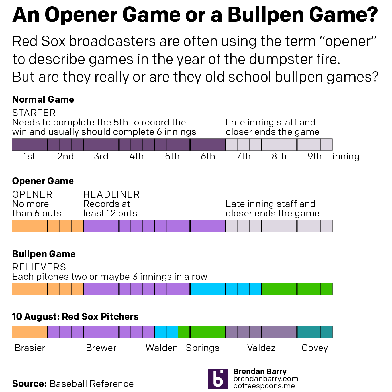
The opener game is relatively new. The idea is in addition to the really good closer, a really good opener records the first inning or two (3–6 outs) to deal with the opposing team’s best hitters. He then hands the ball over to a mediocre starting pitcher who throws the next four or five innings, who then hands the ball over to the late-inning relief specialists. Doing it this way, the starter avoids one set of at-bats or plate appearances by the opposition’s best hitters.

But when is an opener just a bullpen game? Well, it’s when that mediocre starting pitcher isn’t really a starting pitcher. And when he doesn’t even throw four or five innings. Basically all the Red Sox games this year.

I made a graphic this morning to contrast those different types of games and compare them to a game I watched two nights ago between the Red Sox and the Tampa Bay Rays. The game was teed up as an opener with a good relief pitcher by the name of Ryan Brasier starting the first inning. But then instead of a mediocre starter pitching four or five innings, we got a mediocre reliever pitching three innings. He handed it over to a guy who was supposed to go maybe two, but couldn’t get through his second inning. He handed it over to another guy, who handed it over to another guy, who handed it over to a final guy. And none of those last guys were the good relievers you would typically expect to see. (Though, to be fair, the Sox weren’t winning, so why use your best relievers?)

What is an opener and how does it compare to a bullpen game?
Different game types compared

Credit for the piece is mine.

Credit for the Red Sox dumpster fire of a season goes to John Henry and ownership.

Sweet Summer Air of Subway Cars

For those of my readers who live in a city where the subway or underground is a great means of getting around the city, you know you really miss that late Saturday night/early Sunday morning bouquet in the air. Though as this New York Times piece explains, sure it smells bad, but that air is probably safer than you dining indoors at a restaurant or even a child attending class in person.

The piece focuses on New York City subway cars, but they are very similar to the rest of the stock used in the United States. It uses a scrolling reveal to show how the air circulation and filtration systems work. Then it concludes with a model of how a person sneezing appears, both with and without a mask. (Spoiler, wear a mask.)

It’s a really nicely done and informative piece. It compares the rate of air recycled in a subway car to that of several other locations, and the results were a bit surprising to me. Of course, early on in the pandemic before we began to fully understand it, the threat was thought to be from contaminated surfaces—and let’s be honest, there are a lot of contaminated surfaces in a New York City subway car—but we now know the real risk is particles breathed/coughed/sneezed out from one’s mouth and nose. And we can now see just how efficient subways are at cycling and filtering that air.

Credit for the piece goes to Mika Gröndahl, Christina Goldbaum, and Jeremy White.

Covid-19 Update: 9 August

Weekend data means, usually, lower numbers than weekdays. And with the exception of Delaware that’s what we have today. Some drops, like Illinois, are more dramatic than others, like New Jersey. And so we look at the seven-day trend.

And that tells a slightly different story. On the one hand we have states like Virginia and Illinois that appear to be continuing upward. The rise in Illinois has been slow and steady, but the average is approaching nearly 2000 new cases per day. In Virgina, the rise was more abrupt and the question is whether this peak has crested in recent days or if come the middle of next week it will resume rising.

In New Jersey and Delaware we see two states with does declines after some sudden spurts of new cases. Jersey had risen to nearly 500 new cases less than two weeks ago, but that’s now back down to fewer than 350. And in Delaware, while today’s number is greater than yesterday’s, the trend is still downard after being at over 100 new cases per day two weeks ago.

New cases curves for Pennsylvania, New Jersey, Delaware, Virginia, and Illinois.

Then we have Pennsylvania. At one point doing it had done so well in controlling the outbreak to bend the curve to fewer than 500 new cases per day at one point. Then as the state began to reopen, cases began to rise again in the west and now the east. But over the last week that statewide average began to fall. But in the last two days that fall appears to have potentially bottomed out. So come the middle of next week, the question will be does the downward trend continue or has the state hit a new valley before another rise?

Finally, in terms of new deaths, with the exception of Virgina, we have yet to see any rise in deaths that might correlate with the recent rises in new cases. And so nothing new there. But it’s worth pointing out that New Jersey has now reached the high single digits in terms of daily deaths from Covid-19. That’s remarkable for a state that back in April saw nearly 300 people dying every single day.

New death curves for Pennsylvania, New Jersey, Delaware, Virginia, and Illinois.

Credit for the graphics is mine.

Rating Scale

This week is almost over and so instead of a graphic about unemployment numbers, let’s look at a piece from xkcd that provides us all with a new rating scale.

Because, let’s be honest, we all at some point are going to need to rate 2020 come December. And while we still have almost five months remaining, what are you thinking?

Credit for the piece goes to Randall Munroe.

Flood Stages of the Schuylkill

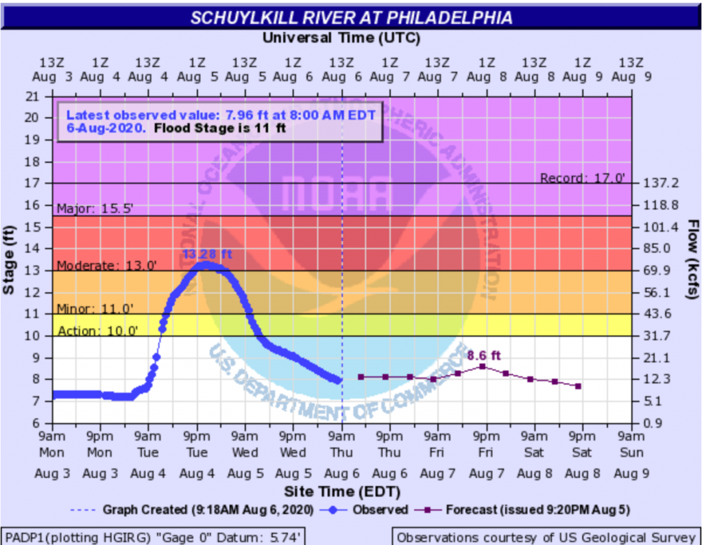
Hurricane Isaias ran up the East Coast of the United States then the Hudson River Valley before entering Canada. Before it left the US, however, it dumped some record-setting amounts of rain in Philadelphia and across the region. And in times of heavy rains, the lower-lying areas of the city (and suburbs like Upper Darby and Downingtown to mention a few) face inundation from swollen rivers and creeks. And in the city itself, the neighbourhood of Eastwick is partially built upon a floodplain. So staying atop river levels is important and the National Weather Service has been doing that for years.

The National Weather Service graphic above is from this very morning and represents the water level of the Schuylkill River (the historical Philadelphia was sited between two rivers, the more commonly known Delaware and its tributary the Schuylkill), which receives water from the suburbs to the north and west of the city, the area hardest hit by Isaias’ rainfall.

The chart looks at the recent as well as the forecast stages of the river. Not surprisingly, the arrival of Isaias accounts for the sudden rise in the blue line. But there is a lot going on here, yellows, reds, and purples, some kind of NOAA logo behind the chart, labels sitting directly on lines, and some of the type is pixellated and difficult to read.

But it does do a nice job of showing the differences in observations and forecast points in time. By that I mean, a normal line chart has an equal distribution of observations along its length. There is an equal space between the weeks or the months or the years. But in instances like this, observations may not be continuous—imagine a flood destroying a sensor—or here that the forecasts are not as frequently produced as observations. And so these are all called out by the dots on the lines we see.

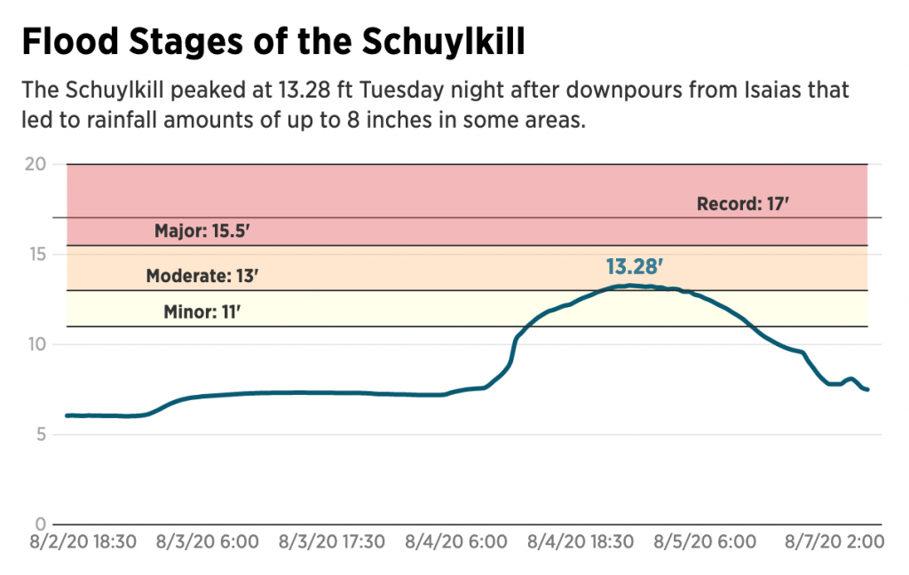
This is the chart I am accustomed to seeing. But then last night, reading about the damage I came across this graphic (screenshot also from this morning to compare to above) from the Philadelphia Inquirer.

It takes the same data and presents it a cleaner, clearer fashion. The flood stages are far easier to read. Gone is the NOAA logo and the unnecessary vertical gridlines. The type is far more legible and the palette less jarring and puts the data series in front and centre.

In general, this is a tremendous improvement for the legibility of the chart. I would probably use a different colour for the record flood stage line, or given their use of solid lines for the axis maybe make it dotted. But that’s a small quibble.

The only real issue here is what happens to the time? Compare the frequent observations in the past in the original, every half hour or so, to the six hourly dots (the blue versus the purple). In the Inquirer version, those spaces between forecast points disappear and become the same as the half-hour increments.

To be fair, the axis labelleing implies this as the label goes from August 4 to 5 and then jumps all the way to 7, but it is not as intuitive as it could be. Here I would recommend following the National Weather Service’s fashion of adjusting for the time gap. It would probably mean some kind of design tweak to emphasise that the observations earlier than now are observed every half hour or so, versus the six-hour forecasts. The NWS did this through dots. One could use a dotted line, or some other design treatment.

This missing time is the only thing really holding back this piece from the Inquirer from standing out as a great update of the traditional National Weather Service hydrograph chart.

Credit for the National Weather Service piece goes to the National Weather Service.
Credit for the Inquirer piece goes to Dominique DeMoe.

The Covid Recession’s Continuing Impact on Youth

Earlier this week, some of the work work my team does was published. We produced a one-page summary of a far larger and more comprehensive (relative to the scope of the summary) survey of consumers during the Covid Recession. I will spare you the details of recreating existing templates from scratch and the design decisions that went into that bit—neither insignificant nor unsubstantial—and rather focus on the one graphic we designed.

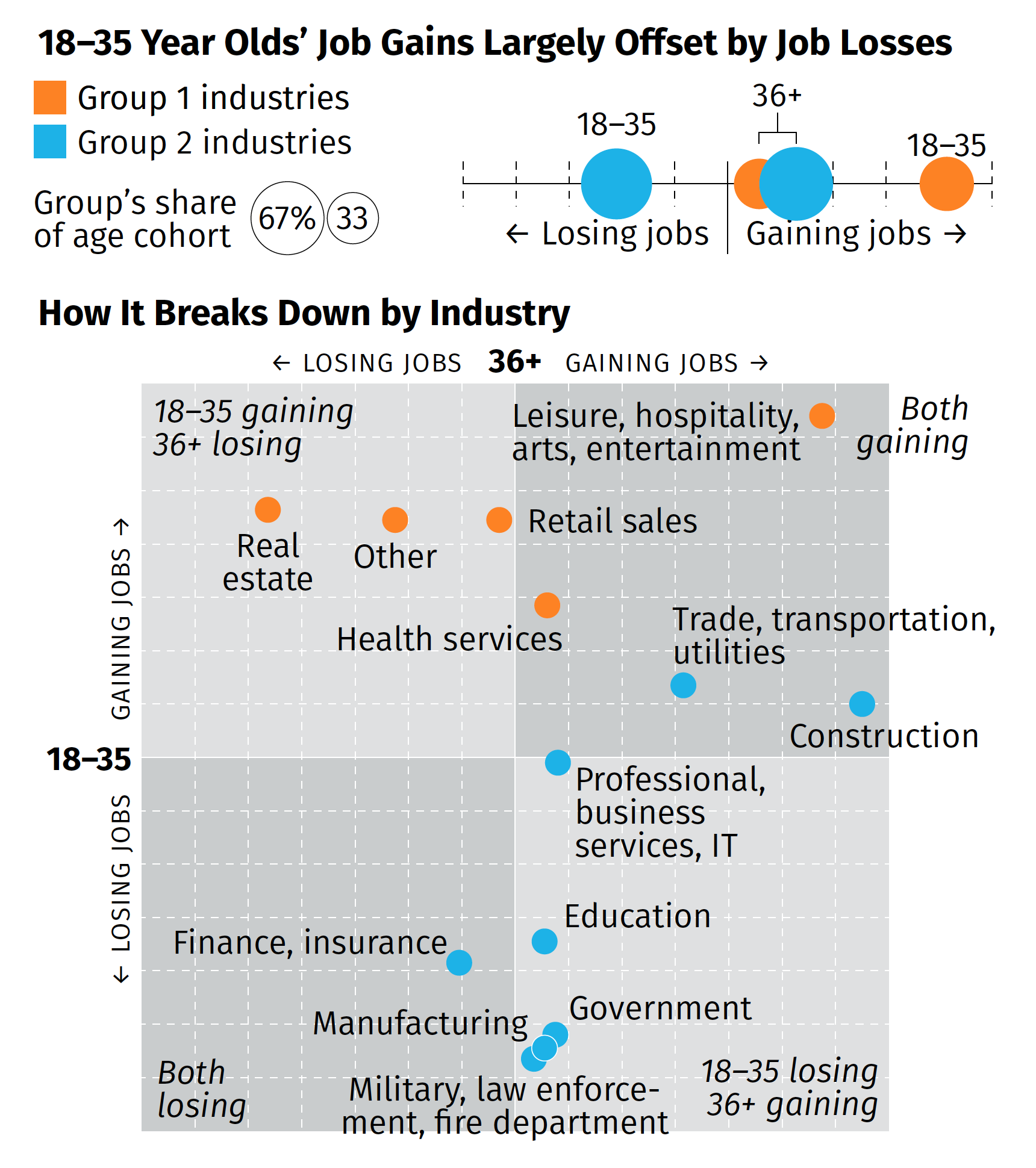
The broad thrust of the summary is that while overall we are beginning to see some job recovery, that the recovery is uneven and that, in fact, those below the age of 36 are getting hit pretty hard (my words, not the authors). That while in some industries the young are recovering in good numbers, in other industries, industries with a larger share of the youth population, young people are still losing jobs. Then we broke those top line numbers out by industries in the below graphic captured by screenshot.

How different age groups in different industries are faring in the recession.

There are a couple of things from a design side to discuss. We had about two or three days from when we started the project to develop some ideas and then execute and produce the summary. And as I noted above, that also included quite a bit of time in emulating existing documents and building ourselves a new template should we need to do something similar in the future.

But for that graphic in particular, there’s one thing I wanted to highlight: the lack of values on the axis. The challenge here was that the data displayed is people not working. And when we compared this time period (Wave 3) to the earlier waves, we were looking for declines. And so if we going to say that 36+ are gaining construction jobs, that would be -2% value and the youth are about a -13% increase. If you are doing a bit of a double-take at a negative increase, so did the team. Ultimately, we used the data to generate the chart, but then opted for qualitative labelling on the axes. They simply point that in one direction, youth are either gaining or losing jobs, and the same for the 36+. To reinforce this idea, we also added some descriptors in the far corner of each quadrant that said whether the age groups were gaining or losing jobs.

Despite the unusual design decisions I took in the graphic, I’m really proud of this piece especially given its tight turnaround. It shows in almost real-time how fractured the recovery—is this a recovery?—is at this point.

Credit for the piece goes to the team on this, Tom Akana, Kate Gamble, Natalie Spingler, and myself.