Proposed Expansion of Massachusetts Railway Network

When we talk about new rail projects, or even highway or airport expansions, we like to include maps of new routes and destinations. In that sense this map from the New York Times is not new. However, we often forget in such visualisations that we have the opportunity to add layers of information that show why these expansions are beneficial.
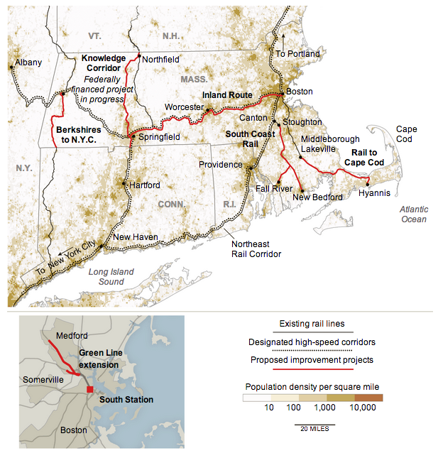
Proposed Massachusetts railway network expansion


Here, note in particular how the proposed improvement projects link the dense corridor of urban settlements stretching from Boston through Worcester to Springfield. Additional lines connect more distant southerly cities such as Fall River to Boston. These might normally be seen as dots at ends of a line, but by showing the density of the population in these corridors, readers can understand how the proposed lines might benefit more people than just those living at the dots.

Credit for the piece goes to the New York Times.

The Life Expectancy Gap Between Men and Women

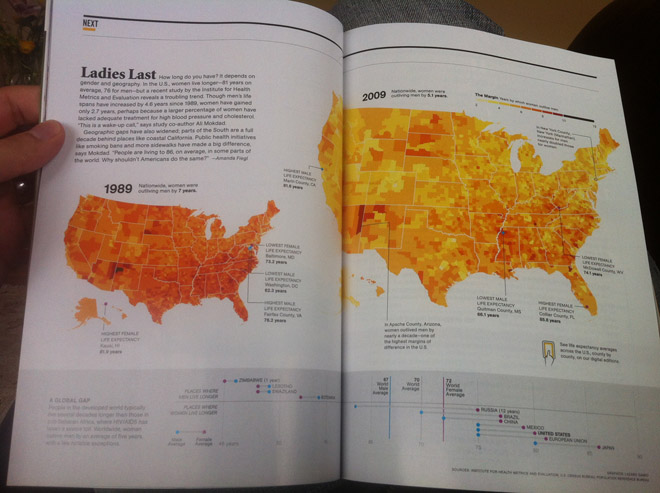
Today’s post comes via my coworker Jonathan and his subscription to National Geographic. The spread below looks at the gap in life expectancy between men and women in the United States. Outliers are highlighted by drawing lines to the counties in question while the same colour scale is used on a smaller map to look at historic data. And of course for those concerned about how the US places amongst its piers on the international stage, a small selection of countries are presented beneath in a dot plot that looks at the differences and averages.

The National Geographic spread
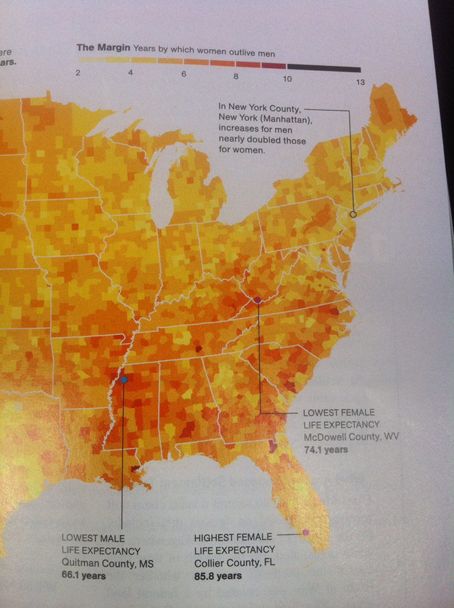
A detail of the choropleth map
A closer look at the dot plot

Credit for the piece goes to Lazaro Gamio.

Pro Tip #314: Don’t Stare Into the Sun

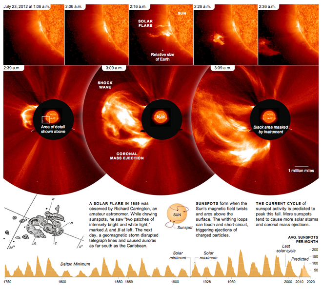
Don’t stare into the sun. It’ll burn your eyes out, kid. Okay, so maybe that’s a stretch of a reference, but, seriously, don’t. Let the professionals do it with (properly shielded) telescopes and such. This piece from the New York Times looks at a solar flare from 2012 and shows how quickly it developed. The bottom of the piece then shows the reader the frequency of solar minimums and maximums along with some explanatory graphics about just what flares and sunspots are and how they are created.

Also note the centre panel in the top row for the relative size of Earth. Yeah, who’s feeling big now? (Not me.)

Don't stare into it…

Credit for the piece goes to Jonathan Corum.

Analysing Amtrak

The Brookings Institution released a report investigating the ridership of Amtrak’s various routes in an attempt to identify ways of cutting costs. They also released an interactive piece along with the report that pairs a map with a simple table.

Highlighting a route in the table highlights the route in the map and links the two together for the user. Clicking a dot on the map shows the details for the metropolitan area ridership along with the total number of stations. Lastly, because the table is sortable, the user can identify for themselves the conclusion reached by the report. To become solvent, Amtrak should divest itself of its long-haul routes that run at significant losses and focus on the profitable routes that could subsidise the popular though still minor loss-making routes.

Amtrak routes with the Northeast Regional highlighted

Credit for the piece goes to Alec Friedhoff.

The United States Compared to the Rest of the World

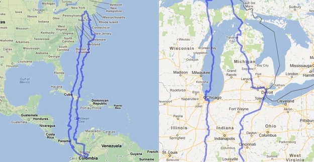
Have you ever wondered how big the United States is? MAPfrappe allows you to compare different geographies in Google Maps.

My employer has an office in Chicago and an office in Santiago, Chile. How big is Chile? North-to-south it is quite large. But east to west, the distance is like that of driving from Chicago to Detroit.

The United States compared to Chile

Via BuzzFeed.

The Reach of Nazi Concentration Camps

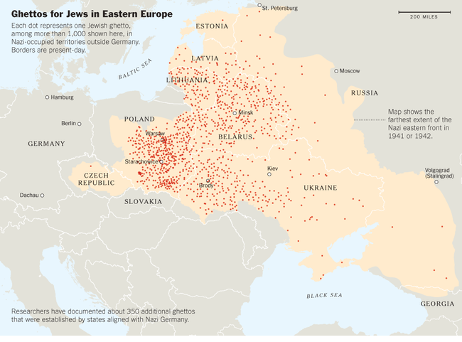
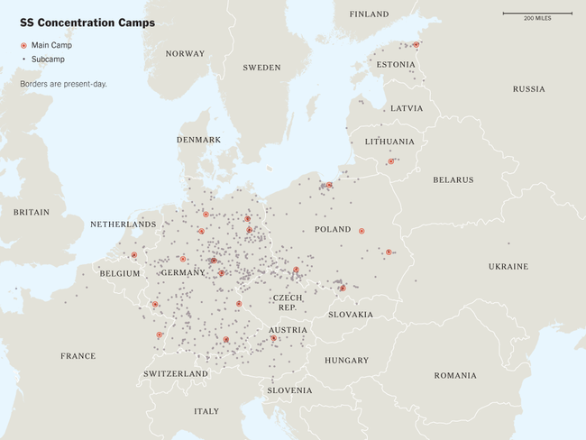
In a truly disturbing article, the New York Times detailed recent research by the United States Holocaust Memorial Museum to identify all the camps established by Germany in World War II, be them extermination camps, labour camps, ghettos, &c. At one point in the article, one of the principals behind the USHMM work stated he expected to find as many as 7,000 such camps across Europe. They have currently identified 42,500.

Two maps accompany the article. The first details the reach of ghettos for Eastern European Jews.

Map of ghettos across Eastern Europe

This second map plots the locations of the primary and secondary SS concentration camps.

Map of SS concentration camps

Credit for the pieces go to the New York Times.

Catholics and Cardinals

As the conclave in Rome is almost ready to begin, likely sometime next week, cardinals are gathering in Rome to discuss the affairs of the Catholic Church and then elect a new pope from within their ranks. Many outsiders talk about the time for a pope from outside of Europe, that the papacy has been an office for Europeans—namely Italians—for too long.

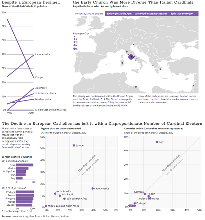
However, the preponderance of Catholics outside of Europe is, in the 2000-year history of the Church, a relatively recent phenomenon. Explosive growth in Latin America, Africa, and Asia combined with a decline in European Catholics means that it is only in the last few decades that Europeans have fallen from being nearly 2/3 of the global Catholic Church.

As my infographic attempts to explain, despite this demographic shift, the early Catholic Church chose popes from the distant corners of its territory before it contracted. That historical consolidation in Europe—Italy in particular—has led, however, to a disproportionate weight of cardinal electors, i.e. the cardinals who elect the pope, in favour of Italy and Europe. And as the cardinals typically choose from among their own, it is far more likely that the next pope will come from Europe if not Italy.

Click the image to see the full-sized graphic.

Catholic demographics and share of the cardinals

Setting Up a Snowstorm

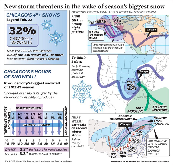
This weekend I researched meteorological data for a graphic that I will post tomorrow. But in doing that research I came across a series of weather infographics from WGN that are better than the average. The one below details the snowstorm due to impact the Chicago area and how it will form (along with the storm that brought a few inches of snow last week).

The setup for this week's snowstorm in Chicago

Credit for the piece goes to Jennifer Kohnke and Faye Shanti.

Blizzard Snowfall

If you do not live on the East Coast, you may be unaware that there was some minor snowfall in New England over this past weekend. The Weather Channel went ahead and named the storm Nemo. (I’m going to lay off the suspect and fishy jokes.) I wanted to revisit the storm because of two graphics that both mapped snowfall totals.

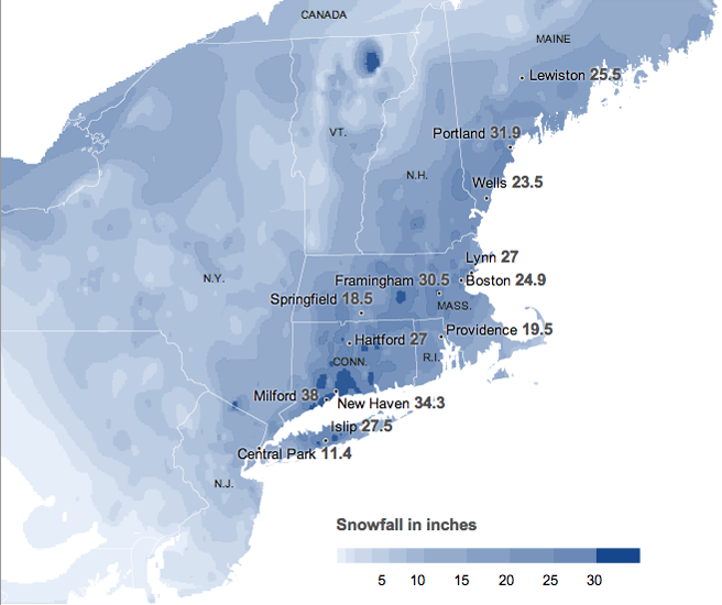
The first is from the New York Times. As one would expect, a quality graphic with clear colour ranges to show the impact across the wider New England area, western New York and New Jersey.

The New York Times snowfall totals

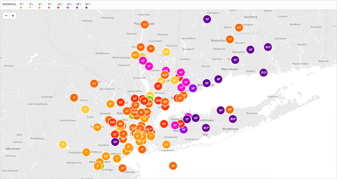
But from the local radio station WNYC came an interesting map of users’ observations. Because it’s a local radio station, the difference between the two versions is that the breadth of data is not as far-reaching as the Times’ data from the National Weather Service.

The limits of WNYC user-reporting

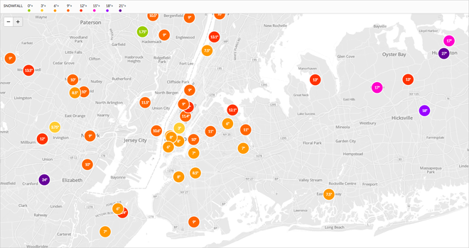
However, this sort of user-created data allows for more nuanced, locally-specific data visualisations.

User-reported snowfall in the near New York area

Of course, this creates issues with the accuracy of the data. And in the case of this map, whether the amount given was a snapshot of the snowfall at the time the snow was falling or the final tally.

Credit for the pieces go to the New York Times, and to Steven Melendez, Louise Ma and John Keefe for the WNYC piece.

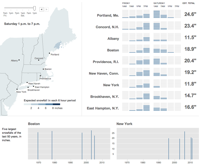
Forecasting Snowfall

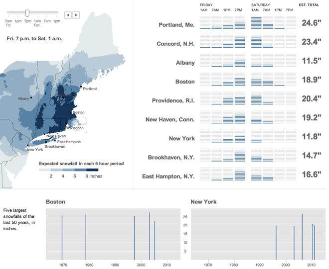
So that fishy little storm the Weather Channel called Nemo—you may have heard of it—put a little snow across New England. Last week the New York Times published an interactive infographic that looked at when and where the snow would be falling, from New Jersey to New York to Maine.

The storm at or near its worst

The times are cut into six-hour blocks and show in the upper left where the snow would be falling by rate per six-hours. To the right of the map is a series of bar charts that show the snowfall pattern in more or less of a wave. Beneath all of it are a comparison of when, over the last several decades, the largest snowstorms hit Boston and New York (and how much snow each city received). A comparison of the map before to the end of the storm, except for parts of Maine.

The forecast for after the worst had passed

Credit for the piece goes to Tom Giratikanon, Matthew Ericson, Xaquin G.V., Archie Tse, and Jeremy White.