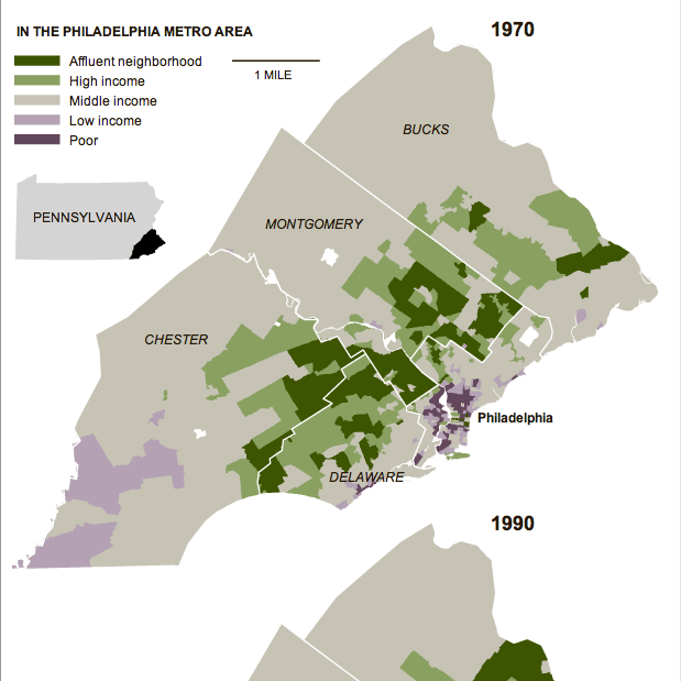
In an area very close to me…quite literally…the New York Times published an article about increasing segregation between the rich and the poor via the areas where they live. The study by Stanford University found that the Philadelphia metropolitan area saw the “sharpest rise” in segregation since the 1970s—the study used census data available through 2007. The accompanying graphic highlights the growth of the segregation from 1970, using small multiples of choropleths to compare 1970 to 1990 to 2007.
In 1970, much of the metro area was middle-income neighbourhoods. Certainly, the central core of Philadelphia was depressed. So too was Chester and rural southwestern Chester County. The upper-income neighbourhoods were in the close suburbs, note the townships stretching due west of the city and you see the Main Line, one of the most affluent areas of the United States, while other veins of wealth extend along other old rail lines leaving the city.

Those such as myself who are familiar with both the area and recent history should note that places like Coatesville and Downingtown are shown as middle-income. In the 1970s, areas like this and in similar places like Falls Township in Bucks County had robust steel and manufacturing sectors that employed a substantial portion of the local population.
But, compare this to 2007 and you will begin to see how many old factory towns of middle-income areas became dense pockets of depression while the city of Philadelphia itself saw a flight of wealth to the rest of the suburbs. The rural parts of Chester, Montgomery, and Bucks have seen high growth by means of new developments of upper-middle- and upper-income homes.
